John Smith Map
Transcript
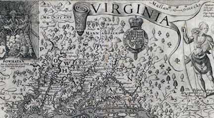
This is a map drawn by John Smith who was one of the first English settlers at Jamestown. And it was first published in 1612 in England. Probably what’s most interesting about the map is just to stop and think: Who did it? Who’s it for? Why is he doing it? What’s he trying to do?
It shows us the worldview of the maker, John Smith, who draws the map. And of the audience, the people in England, members of the Virginia Company, who are investors trying to make money off of this colony of Virginia, who want to hear back that this is a good investment.
It’s a good idea to start out with a few basic orienting things. What’s the orientation? What direction are we coming from? When you look carefully at this map, you’ll see that north is not at the top of the map the way it is in most maps that we’re accustomed to and that most maps at the time in Europe would’ve done. North is to the right. If you stop and think about why that is, it really captures the point of view of somebody looking at the New World from Europe.
How would you approach it? Well, you get a hint with the picture of the ship down in the bottom left. You’re coming on a ship from Europe and this is the European point of view. There are some places, which are named clearly for European figures—Cape Charles, Cape Henry. Jamestown itself, of course, is named for King James. But most of the names are not English names. And this shows how densely populated this area was in the early 17th century by Native peoples.
It tells us something about the style of life in which you live in many different groups with different names. It isn’t clear that all of these Indian groups would’ve thought of themselves as having a common identity beyond owing political allegiance to Powhatan.
Mostly it’s an effort to get information across to the investors in the Virginia Company, who are funding his explorations. The investors did give instructions to the first group of settlers and explorers, saying, “Set up your town and then travel out from there and find out everything.” He’s particularly interested in showing this as a good investment.
He shows the Indian groups that are settled in different areas in order to convince them that there are people there to trade with, people there who can live off of this land. It’s a good land; it sustains life. He’s trying to give them information, but he’s also trying to encourage them to invest more, to have faith in this colony, to support him and the other adventurers. He is trying to be accurate. It’s one of the things you always want to know. How much is this person trying to tell accurate information to the audience. Or are they trying to give a very rosy or maybe a very negative view?
Archeological work confirms that he’s pretty accurate. There seem to be villages where he indicates villages. Maps certainly have to do with laying claim to the territory. Among European powers, the country that has drawn a map of an area does that as part of saying, “this is ours.” Smith isn’t entirely claiming this area. The English have already claimed it, although the Spanish had claimed it earlier.
And as you can see from all the different groups, lots of people claimed it earlier. All these native groups, this is their land. Smith isn’t really contesting at this point whether it’s the Indians’ land or not. Knowledge of where the people are is important in order to understand how much trade can take place in this area.
It says at the top, “Virginia,” although it doesn’t actually cover all the area that the Virginia Company claims to be Virginia.
Powhatan—that’s a name of the chief, but it’s also the name for the group of people who are parts of the empire that Powhatan rules. He’s the leader and he has all these tribes whom he protects. And they pay him tribute, tax, in the form of corn, trade goods, pelts. And that’s what makes him the powerful figure that the English have to deal with.
This helps us understand why it’s limited to this area. It’s not a map of Virginia from the point of view of the Virginia colony and its aspirations to own a great deal more of the continent. And it’s not a map of Jamestown where the English people are settled. It’s a map of Senecomaca, Powhatan’s kingdom.
There’re a couple of answers we come across from the written records. One reason he’s not showing you beyond Powhatan’s area is he’s relying on Powhatan’s Indian guides. They showed him all of the area where they could go freely. When they get to the fall line, you can see that there’re other tribes—the Manahoacs, the Monocans. The Powhatan guides aren’t going to take Smith into enemy territory. So all he can do at that point is take a record and say, “This is where these other Indians are.”
We find out from records of the Virginia Company and letters from Smith and other people in England about what they’re doing and why it’s a good idea to go to Virginia. They’re basing their idea of colonization on what the Spanish did for nearly a century in Mexico and in Peru and in the Caribbean. The Spanish go and find settled Indian groups. They’d like them especially to be rich, like the Incas or the Mayas, to have gold or silver. Then the Spanish conquer them, either through warfare or through diplomatic treaties.
They try to take over at the top so all of the gold, all of the corn, all of the beaver skins, all of the wealth that normally has gone to the dominant chiefs, the Spanish want that to come to them. And they ship that out to Spain. And that’s how they get wealthy. That’s what the English think they’re going to do in Virginia.
It’s an incredibly expensive thing to colonize. The King of England didn’t put up all the money to go settle Virginia, although the King claimed the land. They chartered a private company. In this case the Virginia Company, in which you get investors and they put in money. And they decide to support John Smith and other men who are going to go out and stake a claim and explore what’s there.
The idea of landing in Jamestown is you’ll set up a little town where you can live, and from there you’ll travel out and you’ll find wealth and riches. You’ll find Indian groups with whom you can make alliances. Find out who the important political leaders are. See if you can conquer them or get them to follow you. And see if you can follow the rivers to see if you can get farther into the continent and maybe even to the other side.
Why would Smith want to tell people in England about all these different Indian groups and their names? Aren’t these Indian groups taking up all the land that the English might take up when they come over? And the answer is, initially, that’s not the way the English are looking at it.
They’re looking at it as, “These are people whose wealth we can gain, we can get their crops, the animals they hunt.” And that’s shown up in the map.
In the upper right-hand corner, there’s part of the legend describing what’s on the map. Kings’ houses are a certain size and ordinary houses are another size. Smith is showing there’re all these chiefs and that means this an important political unit. There must be some wealth here. And that’s why this is a good place to settle.
One other aspect of the map that Smith spends a lot of time on is the rivers, showing you the bends and the ups and downs—where it’s wide, where it’s narrow. And that really shows us how he expects the Europeans to enter into the country. They enter in on ships. This is also how they will be transporting the trade goods that they’re getting from these different Indian groups.
It’s very important to the English to think about how they will get wealth back to England. They’re not yet seeing America as, “Here’s a place where we’re going to go and settle and stay.“ Instead, it’s a place we’re going to go, find riches, and return those riches back to England. Some of us may live there on these little outposts such as Jamestown, but most of us will not. And certainly the investors who’re trying to make money, most of them will not actually travel. The closest they get to adventure is reading about it and looking at Smith’s map.
In the upper left is Powhatan, the chief political leader of this time period in this area. It says underneath his name “Powhatan held this state [in] fashion,” meaning he sat and held this meeting in this way. Powhatan is the one with the pipe in his hand. Tobacco ceremonies are part of the diplomacy of the Powhatan people. And he’s got the feathers on his head and he’s wearing some beads or some decoration. And he’s up on a platform. So he’s clearly the big political leader. And beneath him are other people with a fire in this house or building.
The other Indian off to right side is a Susquehannock and he looks rather different. What it says underneath is “The Susquehannahs are a giant-like people and thus attired,” or dressed like this. He’s carrying a bow. He’s carrying a club in his other hand. He’s got an Indian pelt. So he’s depicted as a hunter.
We have here images of two different Indian groups. The suggestion is that one of these groups, the Susquehannahs, are primarily hunters and that what’s important about them is this individual hunting out in the forests. What’s important about the Powhatans is that they are a political group with this important leader.
It’s worth spending some time seeing how different those images are, particularly because we know from other sources that the Susquehannahs also had a political organization. They had chiefs; they had hierarchy. And the Powhatans also hunted. And that was one of the things the English were interested in—how do we get those pelts and furs that might be worth money back in England?
It’s a question that the map presents us with. Why is one group presented this way and the other group presented that way? The map is giving information, but it’s giving selected information about these Indian groups. If we didn’t know from other sources, we might think the Powhatans weren’t primarily hunters or the Susquehannocks didn’t have political institutions.
A choice was made by the mapmaker to emphasize something about these different groups. It tells us that he saw the Susquehannahs in one way, beyond the boundaries of the settled area, out there hunting. And he saw the Powhatans another way, in terms of their political hierarchy.
Powhatan, the paramount chief or political leader of this area, has an idea when the English arrive, too. Which is, “Here’s another tribe; maybe I can add them to the group of tribes with whom I’m allied and to whom I give protection and they will pay me tribute.” So his notion is they may be a useful additional group. They have iron goods. They have guns. They have some really useful things that would make you want to ally with them. They have copper, which is a beautiful good and a good material for making pots that last longer than earthenware. It’s what anthropologists called a “prestige good.” It makes clear that you have access to powers far away. It’s really the same as the Queen of England wearing beaver coats, which show that she has connections and control over the New World.
So from the Powhatan point of view, here’s these new people and they’re kind of interesting. They seem odd because they don’t seem to have any women. It’s hard to understand groups that don’t have women. But I think it’s quite intriguing to think of John Smith on the one hand thinking, “All right, how do I get control of Powhatan and his empire.” And Powhatan thinking on the other hand, “How do I get control of John Smith and his people.” And recognizing that they need help. These are explorers; they’re not farmers. They certainly don’t know how to grow the kind of corn that is grown in North America. The main thing they know how to do is fight and draw maps and explore. The English absolutely need the Indians to help them out.
It certainly isn’t the first place they come to. They come to Cape Charles and Cape Henry and they could’ve gone anywhere up the Chesapeake Bay or any of these other rivers. They go up the river in order to make sure it’s a little bit safer from the Spanish. The Spanish are constantly patrolling the shore of the Atlantic.
Virginia doesn’t really attract the Spanish. They’re happy with their gold from South America and Mexico and the plantation economies in the Caribbean. But they don’t really want the English to get wealthy and become greater competitors. The English know that and they go up the river far enough so they’re not really exposed.
They’re also on the river in case they need to retreat from Indians. Although they expect to be at peace with the Indians and to dominate the Indians, they also know that’s not always going to be true. So they settle right on the water, but up from the coast. It’s deep enough there. It’s not so far up that big ships can’t dock there. Those ships will supply them with food, with tools, and with new settlers. They want to set up a kind of post from which ships will go back and forth to England carrying the wealth that the settlers will be gathering from the countryside.
At the very beginning, it was much less successful than they expected. They suffered immensely from diseases and also they suffered from hunger. There was a drought, so the Indians had less corn themselves than they had normally had to trade and give to the English settlers.
The other aspect was the English settlers were so unprepared to be farmers themselves. They expected both to get food from the Indians and to be able to just gather food from the forest or gather fish from the rivers. And they did do some of that, but it turned out it was a lot harder to live than they thought. So they really needed the support of the Indians.
There was this period historians call the “Starving Time.” You can imagine being an investor in England and thinking this was not a good idea.
Part of the history behind this map is to represent the area as able to sustain life. It’s been a successful settlement so far because we’ve been able to travel throughout and gather this information. Let’s reassure the investors that there’s promise here.
After looking for gold the English try lots of different resources to send back. What they really discover is that tobacco will grow and tobacco becomes this much sought-after item in the 1620s. You can get really rich off tobacco, assuming that you can control enough land and enough labor to work it. Over the next decades, as it turns out that Virginia’s going to become a plantation economy, a society which grows tobacco, it changes the relationships tremendously with the Indians.
Within a couple of decades, there are plantations up and down the James River and it causes great conflict with the different Powhatan groups because those are lands that they use. They may not live on them in settled houses, but they use them for farming or they use them for hunting or they use them to fish along the river.
And the English have no understanding of, or respect for, the Indian’s ideas of ownership and use of the land. So over time, it becomes really clear to the Powhatans that there are more and more English. They’re here to stay. They want more and more land. And so you get a series of wars in the 1620s up through 1640s, when the Powhatans are pushed back.
I would start out with point of view. When you draw the map, you have to stand somewhere and look at the area that you’re mapping. I might ask students where Smith is standing. I guess he’s standing in the Atlantic Ocean or maybe on shipboard. He’s assuming you’re approaching from Europe.
The other thing about every map is it’s a small image of a big area. So the mapmaker had to leave a lot of things out. I would ask what kinds of things got put in and maybe what got left out. For example, we could imagine other things that Smith could’ve put on his map. We could say, well, “Why did he put on the rivers, not roads?” Well, they don’t have roads. There’re certainly paths, but the way you’re going to travel is by water.
He could’ve put on the different kinds of trees or animals that lived here. Or the different kinds of soil. There’re any number of physical features that he could have emphasized. But he was really interested in all these different Native American groups. Students could speculate: Why is that what’s most important or most interesting to the people back in England? Maybe if there had been gold, he would’ve done a map showing that.
You could ask students, to put themselves in the Native Americans’ position. What kind of map would you draw? At the very least it would be turned around, and you’d have some ships coming towards you off the Atlantic instead of sailing away from you. And the English would be this little group over here in Jamestown.
It might not look too different in some ways, but instead of these Indians, they might have images of the English settlers. And it would say, “The English are a giant people and they are thus attired. They carry these odd guns. They have no women.”
Curator Barbara Clark Smith examines John Smith’s 1612 map of a section of Virginia, asking why Smith included what he did, why he left things out, and what he hoped people who saw this map would take away from it.