myHistro
Overview
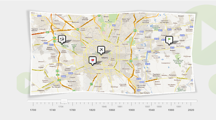
myHistro is a visual tool that combines maps and a timeline to tell the story of change over time and place. The platform enables users to create narratives by plotting events across both geography and time, incorporating multimedia elements like video, images, and text.
Getting Started
Register with your name and email address. The creation process involves selecting “Create a New Story” and providing a title, description, and thumbnail image. You can add multiple authors for collaborative projects, configure privacy settings, tags, and comment permissions, then create events with specific dates (supporting BC dates) and geographic locations. Map tools include satellite, hybrid, and terrain views, plus drawing capabilities.
Example
An AP U.S. History class collectively documented important events from 1619-1919, with each student contributing individual events. The tool also works well for pre/post-lesson resources, such as an American Revolution story tracking colonial discontent (1689-1789) with explanatory text and images. myHistro works best with middle school students and above due to its complexity in managing temporal and spatial reasoning.