At a Glance
Description
Did you know that between 1840 and 1929 many maps were not drawn to scale?
Producer
Panoramic Maps, 1847-1929

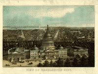
This site presents more than 1,000 original panoramic maps, "a popular cartographic form" during the late 19th and early 20th centuries. The maps, often prepared for civic organizations, such as chambers of commerce and real estate agents, to promote an area's commercial potential, cover the contiguous 48 states and four Canadian provinces of British Columbia, Nova Scotia, Ontario, and Quebec between 1847 and 1929. While most of these maps were not drawn to scale, viewers can zoom in to find artists' renderings of individual streets, buildings, and landscape features. The site also includes a 1,200-word history of panoramic mapping; a bibliography comprised of 24 titles; and background essays (1,000 words) and images relating to five prominent panoramic artists: Albert Ruger (1829-1899), Thadeus Mortimer Fowler (1842-1922), Oakley H. Bailey (1843-1947), Lucien R. Burleigh (1853-1923), and Henry Wellge (1850-1917). This site is an excellent resource for those studying urbanization, cities, business growth, and the art of mapmaking.