At a Glance
Description
More than 540 urban maps of Georgia from between 1884 and 1922, detailing business locations.
Producer
Sanborn® Fire Insurance Maps for Georgia Towns and Cities, 1884-1922

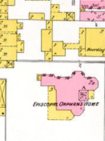
This extensive archive offers detailed color maps for more than 130 Georgia towns and cities between 1884 and 1922. The maps reveal urban landscapes and the locations of businesses, mills, colleges, depots, and other buildings. There are 540 sets of maps and most sets have several or more map sheets. For instance, Atlanta for 1911 has 395 map sheets covering the entire city with three index maps and Savannah for 1916 has 137 map sheets with two index maps. All maps are displayed with their original color coding.
Users can zoom in and out and pan right, left, up, or down to reveal details and every map is accompanied by full bibliographic data. Visitors can browse the collection by county or city or by year of publication; or they can search by keyword, title, city, county, or by address in listed cities. An advanced search feature is also available. Maps for each city are grouped by year with holdings indicated. There are also 17 related links that include two sites on how to read Sanborn maps and seven other digitized collections of Sanborn maps. The maps provide many details about the mills and other industries in these towns, and they are particularly useful in revealing spatial relationships and location of railroad lines. An extremely useful resource for researching the business or urban history of Georgia in the decades around 1900.