At a Glance
Description
Explore American and world history through this collection of maps.
Producer
University of Oregon
Mapping History

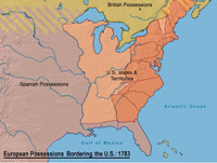
This collection of historical maps, includes maps of the United States divided into 38 topical sections covering pre-1500 through 2000. These units include a variety of materials—from a text introduction and review questions to interactive graphs and maps.
The collection also offers 18 modules on European, Latin American, and African history, ranging in time between Greek civilization and 2000.
Interactive maps and graphs require a shockwave plug-in to access. Useful as geographic aids for those studying U.S. explorations in North America, westward expansion, campaigns against Native Americans, and slavery, among other topics in U.S. and world history.