Point Lookout State Park [MD]

Description

Point Lookout State Park is a peninsula, initially explored by John Smith in 1612. The site suffered British raids during both the Revolutionary War and War of 1812. The use of the word "lookout" in the park's name originates in the peninsula's use as a watch station for British naval activity within the Chesapeake Bay. Still later, the site was used to contain Confederate prisoners of war between 1863 and 1865. Several of the prison guards were African Americans, previously enslaved in the South. Today, features in the park include a U.S. Navy lighthouse; Civil War-era earthworks from Fort Lincoln; reconstructed barracks, officer's quarters, and the partial prison pen; and graves, now open, which originally held Confederate dead.

The park offers exhibits, a nature center, outdoor activities, and self-guided tours of Fort Lincoln.

Mundane Lives and Extreme Adventures jbuescher Thu, 04/08/2010 - 09:47
field_image
Pot and platter of Miles Standish
Question

What were the primary concerns of life in the New World?

Answer

Let me somewhat arbitrarily focus the question more specifically on the earliest English explorers, adventurers, and settlers in Virginia and Massachusetts in the first half of the 17th century.

Reading their published accounts gives one the impression that their lives alternated between extremes of feast and famine, between health and sickness, between sublime ease and almost unimaginable hardship, and between periods of contentment and even boredom and periods of sharp fear and terror interspersed with periods of sheer joy. Supplementing those accounts, however, with evidence from rather more mundane sources such as probate and account books, old court records, and modern excavations of kitchen middens from colonial sites, yields a larger story of people organizing and conducting their work and family lives in ways similar to ours today.

The "Commodities" of Life in the English Settlements in the New World

Captain John Smith published A Description of New England in 1616 in London, in which account he sought, among other things, to recruit English settlers. In it he declared:

Worthy is that person to starve that here cannot live; if he have sense, strength and health: for there is no such penury of these blessings in any place, but that a hundred men may, in one houre or two, make their provisions for a day: and he that hath experience to manage well these affaires, with fortie or thirtie honest industrious men, might well undertake (if they dwell in these parts) to subject the Salvages, and feed daily two or three hundred men, with as good corn, fish and flesh, as the earth hath of those kindes, and yet make that labor but their pleasure; provided that they have engins, that be proper for their purposes.

The first minister in the Massachusetts Bay Colony, Reverend Francis Higginson, acting, like Smith, as a kind of colonial recruiter, published New-England's Plantation; or, a short and true description of the commodities and discommodities of that countrey in 1630 in London. In it, he praised the "fat black earth" around the Charles River in Massachusetts. The land, he said, was extremely fertile, and was well suited to the plow. "It is scarce to be believed how our kine and goats, horses and hogs do thrive and prosper here, and like well of this country." He bragged of the vast harvest of corn, turnips, parsnips, carrots, watercress, "pumpions," "cowcumbers," and herbs. He wrote that the colonists also planted and harvested mulberries, plums, raspberries, currants, chestnuts, filberts, walnuts, cherries, and strawberries.

He wrote about the abundance of game: deer and bear, as well as the other animals, listing wolves, foxes, beavers, otters, martins, great wild cats, and "a great beast called a molke"—most probably a moose. The abundance of fish was "almost beyond believing." Cod, mackerel, bass, and sturgeon; oysters, clams, mussels, and lobsters were easy to catch or gather. Of lobsters, Higginson wrote that "the least boy in the Plantation may both catch and eat what he will of them. For my own part, I was soon cloyed with them, they were so great, and fat, and luscious. I have seen some myself that have weighed sixteen pound; but others have had diverse times so great lobsters as have weighted twenty-five pound, as they assured me."

Higginson commended the "temper of the air" of New England as healthful. He noted that summers were hotter than in England and winters were colder, but he said that the cold was not so bad because of the ease of getting firewood. "Here is good living," he wrote, "for those that love good fires."

The "Discommodities"

Higginson's improbably upbeat list of New England's "discommodities" was much shorter: First, mosquitoes; second, the snow and cold of winter; third; poisonous snakes; and fourth, the lack of more settlers. This last "discommodity" is telling, and does much to explain the hearty promotional tone of the rest of his description.

In fact, many of the first settlers, both in Massachusetts and Virginia, died of starvation, which especially afflicted them during the first winters. Several times, Indians brought them some relief with baskets of corn and game.

Diseases of one kind or another also took their toll. Some of these they brought with them, such as smallpox. Some of them, like dysentery and scurvy, were the result of malnutrition or lack of fresh drinking water. The sheer physical difficulties involved in exploration and in building a settlement in the wilderness also presented tremendous hazards to those that undertook the work.

Shipwreck was also common, especially from the hurricanes and nor'easters that were novel to them. Shipwrecks not only endangered their own lives but also imperiled the re-provisioning of the colonies from England. This was especially critical in the first years of the settlements, when their vulnerability was increased by the fact that they had to depend on ships to supply them, not just with food, but also with basic goods, such as gunpowder, firearms, tools, iron, and cloth.

Colonel Henry Norwood's pamphlet, A Voyage to Virginia, described his harrowing trip in the fall of 1649 from England, in which his ship met storms off the coast of Cape Hatteras and they were blown offshore. He and a small party of others were eventually marooned on an uninhabited island off the coast of Maryland and nearly starved until being rescued by Indians and carried by them to the colony at Jamestown:

Of the three weak women before mentioned, one had the envied happiness to die about this time; and it was my advice to the survivors, who were following her apace, to endeavour their own preservation by converting her dead carcase into food, as they did to good effect. The same counsel was embrac'd by those of our sex; the living fed upon the dead; four of our company having the happiness to end their miserable lives on Sunday night the day of January___. Their chief distemper, 'tis true, was hunger; but it pleased God to hasten their exit by an immoderate access of cold, caused by a most terrible storm of hail and snow at north-west, on the Sunday aforesaid, which did not only dispatch those four to their long homes, but did sorely threaten all that remained alive, to perish by the same fate.

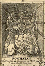
The colony in Virginia was established in the midst of the Algonquian nation of Powhatan, and the Plymouth Colony on the land of the Wampanoag tribe. Relations with the Indians were sketchy and volatile, consisting of periods of friendship interspersed with periods of fighting, sometimes alongside the Indians of one tribe against its enemies from other tribes. The colonists traded metal implements and cloth for food, furs, and land. But they also carefully constructed fortifications and palisades to protect themselves against the almost certain eventuality of attack by the various tribes and nations of Indians among whom they settled. Both colonies suffered large loss of life from Indian attack.

All in all, much of the earliest settlers' time and energies were devoted to providing for their basic, physical subsistence and doing what they could to ensure their survival. Much of the colonies' early precariousness was due to not having yet cleared and planted enough land to ensure harvests that would not only provide the colonists daily fare, but would also allow a surplus to draw upon during times of scarcity.

Until about the mid-20th century, historians largely worked from the writings of the colonists and explorers to understand what colonial life was like. But those writings offered only a very selective picture. For the past several decades, detailed research by archeologists and archivists into the material culture of the colonists has dramatically broadened and sometimes corrected the historical picture.

For more information

The History of Jamestown at Preservation Jamestown.

The Plymouth Colony Archive Project at the University of Virginia.

Bibliography

Images:
"The settlers at Jamestown," William Ludwell Sheppard, 1876, from Pioneers in the settlement of America: from Florida in 1510 to California in 1849. Boston: Samuel Walker, 1876-1877. New York Public Library.

"The pot and platter of Miles Standish," detail from Plymouth stereoview collection. New York Public Library.

John Smith Map

Video Overview

Curator Barbara Clark Smith examines John Smith’s 1612 map of a section of Virginia, asking why Smith included what he did, why he left things out, and what he hoped people who saw this map would take away from it.

Video Clip Name
JohnSmith1.mov
JohnSmith2.mov
JohnSmith3.mov
JohnSmith4.mov
Video Clip Title
Exploring the Map
What is Important?
Different Perspectives
What Questions Can Students Ask?
Video Clip Duration
5:36
6:21
4:15
3:37
Transcript Text

This is a map drawn by John Smith who was one of the first English settlers at Jamestown. And it was first published in 1612 in England. Probably what’s most interesting about the map is just to stop and think: Who did it? Who’s it for? Why is he doing it? What’s he trying to do?

It shows us the worldview of the maker, John Smith, who draws the map. And of the audience, the people in England, members of the Virginia Company, who are investors trying to make money off of this colony of Virginia, who want to hear back that this is a good investment.

It’s a good idea to start out with a few basic orienting things. What’s the orientation? What direction are we coming from? When you look carefully at this map, you’ll see that north is not at the top of the map the way it is in most maps that we’re accustomed to and that most maps at the time in Europe would’ve done. North is to the right. If you stop and think about why that is, it really captures the point of view of somebody looking at the New World from Europe.

How would you approach it? Well, you get a hint with the picture of the ship down in the bottom left. You’re coming on a ship from Europe and this is the European point of view. There are some places, which are named clearly for European figures—Cape Charles, Cape Henry. Jamestown itself, of course, is named for King James. But most of the names are not English names. And this shows how densely populated this area was in the early 17th century by Native peoples.

It tells us something about the style of life in which you live in many different groups with different names. It isn’t clear that all of these Indian groups would’ve thought of themselves as having a common identity beyond owing political allegiance to Powhatan.

Mostly it’s an effort to get information across to the investors in the Virginia Company, who are funding his explorations. The investors did give instructions to the first group of settlers and explorers, saying, “Set up your town and then travel out from there and find out everything.” He’s particularly interested in showing this as a good investment.

He shows the Indian groups that are settled in different areas in order to convince them that there are people there to trade with, people there who can live off of this land. It’s a good land; it sustains life. He’s trying to give them information, but he’s also trying to encourage them to invest more, to have faith in this colony, to support him and the other adventurers. He is trying to be accurate. It’s one of the things you always want to know. How much is this person trying to tell accurate information to the audience. Or are they trying to give a very rosy or maybe a very negative view?

Archeological work confirms that he’s pretty accurate. There seem to be villages where he indicates villages. Maps certainly have to do with laying claim to the territory. Among European powers, the country that has drawn a map of an area does that as part of saying, “this is ours.” Smith isn’t entirely claiming this area. The English have already claimed it, although the Spanish had claimed it earlier.

And as you can see from all the different groups, lots of people claimed it earlier. All these native groups, this is their land. Smith isn’t really contesting at this point whether it’s the Indians’ land or not. Knowledge of where the people are is important in order to understand how much trade can take place in this area.

It says at the top, “Virginia,” although it doesn’t actually cover all the area that the Virginia Company claims to be Virginia.

Powhatan—that’s a name of the chief, but it’s also the name for the group of people who are parts of the empire that Powhatan rules. He’s the leader and he has all these tribes whom he protects. And they pay him tribute, tax, in the form of corn, trade goods, pelts. And that’s what makes him the powerful figure that the English have to deal with.

This helps us understand why it’s limited to this area. It’s not a map of Virginia from the point of view of the Virginia colony and its aspirations to own a great deal more of the continent. And it’s not a map of Jamestown where the English people are settled. It’s a map of Senecomaca, Powhatan’s kingdom.

There’re a couple of answers we come across from the written records. One reason he’s not showing you beyond Powhatan’s area is he’s relying on Powhatan’s Indian guides. They showed him all of the area where they could go freely. When they get to the fall line, you can see that there’re other tribes—the Manahoacs, the Monocans. The Powhatan guides aren’t going to take Smith into enemy territory. So all he can do at that point is take a record and say, “This is where these other Indians are.”

We find out from records of the Virginia Company and letters from Smith and other people in England about what they’re doing and why it’s a good idea to go to Virginia. They’re basing their idea of colonization on what the Spanish did for nearly a century in Mexico and in Peru and in the Caribbean. The Spanish go and find settled Indian groups. They’d like them especially to be rich, like the Incas or the Mayas, to have gold or silver. Then the Spanish conquer them, either through warfare or through diplomatic treaties.

They try to take over at the top so all of the gold, all of the corn, all of the beaver skins, all of the wealth that normally has gone to the dominant chiefs, the Spanish want that to come to them. And they ship that out to Spain. And that’s how they get wealthy. That’s what the English think they’re going to do in Virginia.

It’s an incredibly expensive thing to colonize. The King of England didn’t put up all the money to go settle Virginia, although the King claimed the land. They chartered a private company. In this case the Virginia Company, in which you get investors and they put in money. And they decide to support John Smith and other men who are going to go out and stake a claim and explore what’s there.

The idea of landing in Jamestown is you’ll set up a little town where you can live, and from there you’ll travel out and you’ll find wealth and riches. You’ll find Indian groups with whom you can make alliances. Find out who the important political leaders are. See if you can conquer them or get them to follow you. And see if you can follow the rivers to see if you can get farther into the continent and maybe even to the other side.

Why would Smith want to tell people in England about all these different Indian groups and their names? Aren’t these Indian groups taking up all the land that the English might take up when they come over? And the answer is, initially, that’s not the way the English are looking at it.

They’re looking at it as, “These are people whose wealth we can gain, we can get their crops, the animals they hunt.” And that’s shown up in the map.

In the upper right-hand corner, there’s part of the legend describing what’s on the map. Kings’ houses are a certain size and ordinary houses are another size. Smith is showing there’re all these chiefs and that means this an important political unit. There must be some wealth here. And that’s why this is a good place to settle.

One other aspect of the map that Smith spends a lot of time on is the rivers, showing you the bends and the ups and downs—where it’s wide, where it’s narrow. And that really shows us how he expects the Europeans to enter into the country. They enter in on ships. This is also how they will be transporting the trade goods that they’re getting from these different Indian groups.

It’s very important to the English to think about how they will get wealth back to England. They’re not yet seeing America as, “Here’s a place where we’re going to go and settle and stay.“ Instead, it’s a place we’re going to go, find riches, and return those riches back to England. Some of us may live there on these little outposts such as Jamestown, but most of us will not. And certainly the investors who’re trying to make money, most of them will not actually travel. The closest they get to adventure is reading about it and looking at Smith’s map.

In the upper left is Powhatan, the chief political leader of this time period in this area. It says underneath his name “Powhatan held this state [in] fashion,” meaning he sat and held this meeting in this way. Powhatan is the one with the pipe in his hand. Tobacco ceremonies are part of the diplomacy of the Powhatan people. And he’s got the feathers on his head and he’s wearing some beads or some decoration. And he’s up on a platform. So he’s clearly the big political leader. And beneath him are other people with a fire in this house or building.

The other Indian off to right side is a Susquehannock and he looks rather different. What it says underneath is “The Susquehannahs are a giant-like people and thus attired,” or dressed like this. He’s carrying a bow. He’s carrying a club in his other hand. He’s got an Indian pelt. So he’s depicted as a hunter.

We have here images of two different Indian groups. The suggestion is that one of these groups, the Susquehannahs, are primarily hunters and that what’s important about them is this individual hunting out in the forests. What’s important about the Powhatans is that they are a political group with this important leader.

It’s worth spending some time seeing how different those images are, particularly because we know from other sources that the Susquehannahs also had a political organization. They had chiefs; they had hierarchy. And the Powhatans also hunted. And that was one of the things the English were interested in—how do we get those pelts and furs that might be worth money back in England?

It’s a question that the map presents us with. Why is one group presented this way and the other group presented that way? The map is giving information, but it’s giving selected information about these Indian groups. If we didn’t know from other sources, we might think the Powhatans weren’t primarily hunters or the Susquehannocks didn’t have political institutions.

A choice was made by the mapmaker to emphasize something about these different groups. It tells us that he saw the Susquehannahs in one way, beyond the boundaries of the settled area, out there hunting. And he saw the Powhatans another way, in terms of their political hierarchy.

Powhatan, the paramount chief or political leader of this area, has an idea when the English arrive, too. Which is, “Here’s another tribe; maybe I can add them to the group of tribes with whom I’m allied and to whom I give protection and they will pay me tribute.” So his notion is they may be a useful additional group. They have iron goods. They have guns. They have some really useful things that would make you want to ally with them. They have copper, which is a beautiful good and a good material for making pots that last longer than earthenware. It’s what anthropologists called a “prestige good.” It makes clear that you have access to powers far away. It’s really the same as the Queen of England wearing beaver coats, which show that she has connections and control over the New World.

So from the Powhatan point of view, here’s these new people and they’re kind of interesting. They seem odd because they don’t seem to have any women. It’s hard to understand groups that don’t have women. But I think it’s quite intriguing to think of John Smith on the one hand thinking, “All right, how do I get control of Powhatan and his empire.” And Powhatan thinking on the other hand, “How do I get control of John Smith and his people.” And recognizing that they need help. These are explorers; they’re not farmers. They certainly don’t know how to grow the kind of corn that is grown in North America. The main thing they know how to do is fight and draw maps and explore. The English absolutely need the Indians to help them out.

It certainly isn’t the first place they come to. They come to Cape Charles and Cape Henry and they could’ve gone anywhere up the Chesapeake Bay or any of these other rivers. They go up the river in order to make sure it’s a little bit safer from the Spanish. The Spanish are constantly patrolling the shore of the Atlantic.

Virginia doesn’t really attract the Spanish. They’re happy with their gold from South America and Mexico and the plantation economies in the Caribbean. But they don’t really want the English to get wealthy and become greater competitors. The English know that and they go up the river far enough so they’re not really exposed.

They’re also on the river in case they need to retreat from Indians. Although they expect to be at peace with the Indians and to dominate the Indians, they also know that’s not always going to be true. So they settle right on the water, but up from the coast. It’s deep enough there. It’s not so far up that big ships can’t dock there. Those ships will supply them with food, with tools, and with new settlers. They want to set up a kind of post from which ships will go back and forth to England carrying the wealth that the settlers will be gathering from the countryside.

At the very beginning, it was much less successful than they expected. They suffered immensely from diseases and also they suffered from hunger. There was a drought, so the Indians had less corn themselves than they had normally had to trade and give to the English settlers.

The other aspect was the English settlers were so unprepared to be farmers themselves. They expected both to get food from the Indians and to be able to just gather food from the forest or gather fish from the rivers. And they did do some of that, but it turned out it was a lot harder to live than they thought. So they really needed the support of the Indians.

There was this period historians call the “Starving Time.” You can imagine being an investor in England and thinking this was not a good idea.

Part of the history behind this map is to represent the area as able to sustain life. It’s been a successful settlement so far because we’ve been able to travel throughout and gather this information. Let’s reassure the investors that there’s promise here.

After looking for gold the English try lots of different resources to send back. What they really discover is that tobacco will grow and tobacco becomes this much sought-after item in the 1620s. You can get really rich off tobacco, assuming that you can control enough land and enough labor to work it. Over the next decades, as it turns out that Virginia’s going to become a plantation economy, a society which grows tobacco, it changes the relationships tremendously with the Indians.

Within a couple of decades, there are plantations up and down the James River and it causes great conflict with the different Powhatan groups because those are lands that they use. They may not live on them in settled houses, but they use them for farming or they use them for hunting or they use them to fish along the river.

And the English have no understanding of, or respect for, the Indian’s ideas of ownership and use of the land. So over time, it becomes really clear to the Powhatans that there are more and more English. They’re here to stay. They want more and more land. And so you get a series of wars in the 1620s up through 1640s, when the Powhatans are pushed back.

I would start out with point of view. When you draw the map, you have to stand somewhere and look at the area that you’re mapping. I might ask students where Smith is standing. I guess he’s standing in the Atlantic Ocean or maybe on shipboard. He’s assuming you’re approaching from Europe.

The other thing about every map is it’s a small image of a big area. So the mapmaker had to leave a lot of things out. I would ask what kinds of things got put in and maybe what got left out. For example, we could imagine other things that Smith could’ve put on his map. We could say, well, “Why did he put on the rivers, not roads?” Well, they don’t have roads. There’re certainly paths, but the way you’re going to travel is by water.

He could’ve put on the different kinds of trees or animals that lived here. Or the different kinds of soil. There’re any number of physical features that he could have emphasized. But he was really interested in all these different Native American groups. Students could speculate: Why is that what’s most important or most interesting to the people back in England? Maybe if there had been gold, he would’ve done a map showing that.

You could ask students, to put themselves in the Native Americans’ position. What kind of map would you draw? At the very least it would be turned around, and you’d have some ships coming towards you off the Atlantic instead of sailing away from you. And the English would be this little group over here in Jamestown.

It might not look too different in some ways, but instead of these Indians, they might have images of the English settlers. And it would say, “The English are a giant people and they are thus attired. They carry these odd guns. They have no women.”

Using Maps as Primary Sources

Image
Article Body

This website shows a 4th-grade teacher in northern Virginia teaching a lesson focused on a map drawn by John Smith that was published in 1612. Source Analysis, a feature created for the Loudoun County (Virginia) (TAH) website, has three sections focused on this primary source: scholar analysis, teacher analysis, and classroom practice. The latter two sections show a standards-based lesson that asks students to answer the question: What is important to John Smith? The teacher carefully plans activities so students look closely at the map and consider how this primary source helps them answer the central question. The site provides examples of two promising practices:

  • Engaging young students in close, careful observation and reading of a primary source document (using student pairs and a comparative document); and
  • Using students' observations to inform and guide analysis and connect the source to larger questions and topics in the curriculum.
The Lesson in Action

In the Classroom Practice section, we see the lesson in action. The teacher introduces the lesson question and then takes time to ensure that students understand the question by introducing synonyms for "important" and reviewing word meanings. She passes out the maps to assigned student pairs and asks them, "What do you see?" Students have time to look carefully at the map and notice words (e.g., "Jamestown" and "Powhatan"), the Chesapeake Bay and its tributaries, living structures, trees, how particular words vary in size and spacing, and so on. The teacher further facilitates the students' observation by juxtaposing the 1612 map with a contemporary textbook map of the same region. This juxtaposition helps students see the choices John Smith made in drawing this map that they might have missed without the comparative source. The teacher then uses what students notice about these maps to help them think about what the details and differences mean. Students start to identify what was important to John Smith and subsequently to the Virginia Company, given the evidence in front of them. Throughout this instruction, the teacher uses feedback, a logical sequencing of activities, and clear and accessible questions to ensure access to the learning activities for all of her students.

Thinking Like Historians

This teacher shows how carefully structured lessons that use primary sources can engage students in the process of thinking like historians. Students slow down and carefully read and look at the map, noticing things that they might otherwise have missed. They then consider what the contents of the map mean and what the map tells us about John Smith and the Virginia Company's worldview. The 1612 map becomes a window into the past that only reveals its slice of the landscape with close reading. Also on this site is a Teacher Analysis section in which the teacher explains some of what preceded this lesson and her instructional choices—a useful complement to the classroom videos. Each of these sections presents information in a set of videos that are clearly titled and visually interesting.