Archive of Early American Images
Image
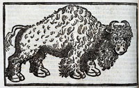
Buffalo, Archive of Early American Images
Annotation

The images in this collection, focusing on the Americas, come from books printed or created in Europe between about 1492 and 1825. Images include woodcuts, copper engravings, and paintings. The database, still being compiled, currently contains 6,685 images and will eventually contain some 7,500 images. Image viewing software is available from the site.

The visitor can browse the entire archive or search by time period, geographical area, keyword, or subject, including indigenous peoples, flora and fauna, artifacts, industry, human activities, geography, maps, city views and plans, and portraits. Some images, such as Ptolemy's map of the world, may be familiar. Others are reproduced for the first time. Navigation requires some practice, but is worth the effort.

The Journeys of Lewis and Clark

Description

Many Americans think Lewis and Clark were sent west simply to explore the newly-acquired Louisiana Purchase. In fact, the Lewis and Clark Expedition was part of an international contest to control North America and exploit its wealth and an important part of Thomas Jefferson's plan for the development of the United States and the future of its Native American population.

Dr. Dan Thorp of Virginia Tech explores the nature of earlier European activities in the North American West and how they shaped the timing and nature of the Lewis and Clark Expedition.

Texas Maritime Museum

Description

The Texas Maritime Museum provides exhibits on the history and technology of offshore petroleum production and transportation; the history and development of Texas seaports, maritime communities, and maritime commerce along the Gulf; the exploration and settlement history of the Texas Gulf Coast, including by the Spanish and the French; and an overview of the Texas seafood and fishing industry.

The museum offers exhibits, tours for school groups, in-class outreach presentations, traveling trunk "treasure chests" for loan, and occasional recreational and educational events.

Corpus Christi Museum of Science and History [TX]

Description

The Corpus Christi Museum of Science and History presents the story of a cultural crossroads of the New World. With a confluence of natural history, science, people, and environments, the South Texas area has served as a stage for the ongoing discovery of the Americas. The museum's exhibits explore natural history and South Texas history, and include full-size, functioning reconstructions of Christopher Columbus's three ships.

The museum offers exhibits, self-guided and guided tours for school groups, tours of the Columbus Ships, traveling trunks available for rent, and occasional recreational and educational events.

Missouri Headwaters State Park [MT]

Description

This park encompasses the confluence of the Jefferson, Madison, and Gallatin Rivers. Lewis and Clark anticipated this important headwaters all the way up the Missouri River. An easy three-mile drive off Interstate 90 at Three Forks, this undeveloped park provides outdoor interpretive signs, picnic spots, short hiking trails, a small campground, and—just as the Corps of Discovery found—plenty of mosquitoes!

The site offers occasional recreational and educational events.

Giant Springs State Park [MT]

Description

This historic freshwater springs site was discovered by the Lewis and Clark Expedition in 1805— it is one of the largest freshwater springs in the world, flowing at a measured 156 million gallons of water per day. This day-use park gives visitors an opportunity to picnic by the Missouri River, visit the fish hatchery and visitor center, walk along the Rivers Edge Trail, view nearby Rainbow Falls overlook, or visit the neighboring Lewis and Clark Interpretive Center operated by the U.S. Forest Service.

The site offers exhibits and occasional recreational and educational events.

Angel Island State Park [CA]

Description

In the middle of San Francisco Bay sits Angel Island State Park. Three thousand years ago, the island was a fishing and hunting site for Coastal Miwok Indians. It was later a haven for Spanish explorer Juan Manuel de Ayala, a cattle ranch, and a U.S. Army post. From 1910 to 1940, the island processed hundreds of thousands of immigrants, the majority from China. During World War II, Japanese and German POWs were held on the island, which was also used as a jumping-off point for American soldiers returning from the Pacific. In the '50s and '60s, the island was home to a Nike missile base.

The site offers tours, exhibits, and educational and recreational programs and events, and works in coordination with the Angel Island Immigration Station Foundation, listed above, for educational programs focusing on the immigration history of the island.

Beluga Point

Description

"The earliest evidence of humans along Turnagain Arm is at Beluga Point, which prehistoric hunters used as a view point to search for Beluga whales and sheep. The first white explorers arrived in 1778 aboard Captain Cook's ships, Discovery and Resolution. Cook sailed up Cook Inlet hoping to find the Northwest Passage, but had to "turn again", leading him to name the water body River Turnagain. In the late 19th century, miners and trappers began traveling into interior Alaska from Whittier and Seward along old trails that soon became established routes with roadhouses. In 1895 prospectors crossed from the south side of Turnagain Arm to the north and searched for gold from Girdwood to Rainbow Creek.

In 1903, the Alaska Central Railway began building a railroad from Seward to Fairbanks, but the company soon went bankrupt. The U.S. Government bought the railroad in 1915 and improved the trail along the arm to handle the horse and wagon traffic needed for railroad construction. The trail was also used to deliver mail between Anchorage and Seward. IN 1917 telegraph lines were laid along the Turnagain "road" and by 1918 the railroad extended from Seward to Anchorage, with flag stops at Bird Creek, Indian, Rainbow and Potter. Remnants of construction camps remain along the trail, but are barely discernible. Part of the original trail was covered by the highway which was completed in 1950 and paved in 1954."

Lewis and Clark Trail Heritage Foundation [MT] Anonymous (not verified) Tue, 01/08/2008 - 13:38
Description

The Lewis and Clark Trail Heritage Foundation seeks to preserve and share the history of the Lewis and Clark Expedition (1803-1806) and the physical sites thereof. To this end, the headquarters hosts the non-circulating William P. Sherman Library and Archives.

The foundation offers research library access, educator training, and research assistance. Appointments are required for library access. The website offers a curriculum guide for purchase, a video, and children's games and activities.

Lewis and Clark State Historic Site: Camp River Dubois

Description

The Lewis and Clark site commemorates Camp Dubois, the 1803–1804 winter camp of Meriwether Lewis and William Clark. It was at the camp on Wood River that members of the Corps of Discovery prepared their expedition to the Pacific Ocean. The site's main feature is an interpretive center that contains a large exhibition gallery, a theater, and a gift shop. The 14,000-square-foot exhibition area contains six galleries that outline the background and history of the Lewis and Clark expedition from its conception to its meaning for today's America. A reconstruction of the winter camp is located on the grounds near the visitor center. Its design reflects 1803 U.S. Army regulations for the construction of military posts. A nearby memorial structure overlooks the modern meeting point of the Mississippi and Missouri rivers.

The site offers exhibits, a short film, occasional living history events, and educational and recreational programs.