Fort Matanzas National Monument

Description

Coastal Florida was a major field of conflict as European nations fought for control in the New World. As part of this struggle, Fort Matanzas guarded St. Augustine's southern river approach. The colonial wars are over, but the monument is still protecting—not just the historic fort, but also the wild barrier island and the plants and animals who survive there amidst a sea of modern development.

The site offers a short film, exhibits, tours, demonstrations, educational programs, and recreational and educational events (including living history events).
George Stevens: D-Day to Berlin

Description

Filmmaker George Stevens, Jr., introduces and discusses D-Day to Berlin, the Emmy Award-winning documentary he made using color footage that his father, director George Stevens, filmed across Europe at the end of World War II. In 1943, Stevens, Sr., was assigned to follow the invasion of Normandy with the 6th Army for the purpose of recording their operations for army archives; the footage used to make up D-Day to Berlin was discovered after his death and follows Stevens and his crew as they follow the Allied Army.

Audio and video options are available.

Alanson B. Houghton: Ambassador of the New Era

Description

Scholar Jeffrey Matthews explores the life of Alanson B. Houghton, American industrialist, politician, and diplomat (to Germany, 1922-1925, and to Great Britain, 1925-1929). Houghton uses this exploration to examine U.S. foreign policy between World War I and World War II, citing Houghton's criticism of policy under Presidents Harding and Coolidge.

Audio and video options are available.

The Slave Trade

Description

Bill White, Executive Producer and Director of Educational Program Development at Colonial Williamsburg, discusses the range of the slave trade and its importance to the colonial and global economy, as well as Colonial Wiliamsburg's efforts to educate on the slave trade and slavery in general.

Northwestern European Military Situation Maps from World War II

Image
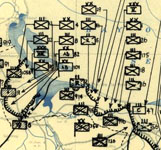
Image, HQ Twelfth Army Group situation map, June 8, 1944, Library of Congress.
Annotation

Created by the First United States Army Group and the Twelfth Army Group, this collection consists of 416 situation maps from World War II. The maps show the daily positions of Allied army units during the campaigns in Western Europe, from the D-Day invasion on June 6, 1944, through Allied occupation in July 26, 1945. There are also more than 100 reports from the campaigns.

Maps offer insight into daily activities, but also a broad view of movement over time. In addition, they highlight the incomplete nature of information available to commanders in the field during war time. Visitors can search the collection or browse the maps and reports by title, creator, subject, place, or date. The site also includes an interactive essay on the Battle of the Bulge. Visitors can select the desired zoom level and window size for viewing maps.

Patriots, Revolution, and Constitutions

Description

Patrick Manning, Andrew W. Mellon Professor of World History at the University of Pittsburgh seeks to widen Constitutional understanding by situating the Constitution's foundation in a global context. He urges listeners to consider social movements from around the world in the quest to understand ways in which the U.S. Constitution was both unique and representative of the era.

To listen to this lecture, select "Lecture Audio: Patriots, Revolution and Constitutions Presentation" under "Presentation Materials."

Cultural Readings: Colonization and Print in the Americas

Image
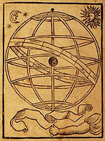
Image for Cultural Readings: Colonization and Print in the Americas
Annotation

Texts about the Americas produced in Europe from the 15th through the 19th centuries are examined in this well-organized online exhibit. Over 100 images of printed texts, drawings, artwork, and maps from published and unpublished sources are arranged into six thematic categories. Categories are named: "Promotion and Possession," "Viewers and the Viewed," "Print and Native Cultures," "Religion and Print," "New World Lands in Print," and "Colonial Fictions, Colonial Histories."

Five scholarly essays (5,000 to 7,000 words each) contextualize the documents. A bibliography and list of links accompany the presentation. A visually attractive, thoughtfully arranged site that explores connections between colonization and representation.

American Family Immigration History Center

Image
Photo,"Immigrants aboard [...],"1892, American Family Immigration History Center
Annotation

Records on the more than 25 million passengers and ship crew members who passed through Ellis Island between 1892 and 1924 are available through this website. Most passengers came from Europe and Russia, although there are some records from Asia, the Caribbean, and Latin America.

The website requires a free, simple registration to view detailed records that include name, residence, date of arrival, age on arrival, ethnicity, place of residence, marital status, ship of travel, place of departure, and a copy of the original ship manifest (a transcription is also available). The website includes extensive contextual information about Ellis Island, immigration, and genealogical research. "Family Histories" illuminates the genealogical research experiences of six Americans of diverse ethnic backgrounds.

The "Peopling of America" exhibit covers six periods from pre-1790 to 2000, with graphs, photographs, and immigration statistics geared to place of origin. Additional information is available for an annual fee.