Jacob Riis, Reformer
Description
This iCue Mini-Documentary introduces Danish immigrant Jacob Riis, who recorded the underbelly of urban life in his photography.
This feature is no longer available.
This iCue Mini-Documentary introduces Danish immigrant Jacob Riis, who recorded the underbelly of urban life in his photography.
This feature is no longer available.
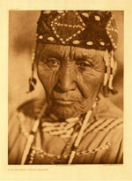
More than 2,000 photographs, taken by Edward S. Curtis for his work The North American Indian, are presented here. These striking images of North American tribes are considered some of the most significant representations produced during a time of rapid change, can be browsed by subjects such as persons, custom, jewelry, tools, and buildings. Each image is accompanied by comprehensive identifying data and Curtis' original captions. The voluminous collection and narrative are presented in twenty volumes. Photographs can be browsed by subject, eighty American Indian tribe names, and seven geographic locations. This site also features a twelve-item bibliography and three scholarly essays discussing Curtis' methodology as an ethnographer, the significance of his work to Native peoples of North America, and his promotion of the twentieth-century view that American Indians were a vanishing race. The biographical timeline and map depicting locations where Curtis photographed American Indian groups are especially useful.

More than 12,000 stereoscopic photographs depict life in small towns, villages, rural areas, and cities throughout New York, New Jersey, and Connecticut from 1850 to 1920 on this website. Materials include pictures of buildings, street scenes, natural landscapes, agriculture, industry, transportation, homes, businesses, local celebrations, natural disasters, and people.
Each grouping of photographs offers a short description of the contents as well as notes on the locations, medium, collection names, and digital identification information. The site also features an essay on the history of stereoscopic views and nine related website links. The site is searchable by keyword and can be browsed by subject and image name. These revealing illustrations are valuable for examining rural and urban development as well as everyday life.
These more than 8,000 images document the history and development of South Texas and the border. The collection features the life's work of commercial photographer Robert Runyon (18811968). Topics include the U.S. military presence in the area prior to and during World War I and the growth and development of the Rio Grande Valley in the early 1900s.
A special section presents nine of Runyon's 350 photographs of the Mexican Revolution (19101920) in Matamoros, Monterrey, Ciudad Victoria, and the Texas border area from 1913 through 1916. "Maps of the Lower Rio Grande" offers a number of topographical and military maps depicting the region. The website also offers essays on the revolution and on Runyon.
More than 1,000 photographs depict Civil War military personnel, preparations for battle, and the aftermath of battles in the main eastern theater and in the west in this collection. Photographs also include Federal Navy and Atlantic seaborne expeditions against the Confederacy, Confederate and Union officers and enlisted soldiers, and Washington, DC during the war. Most images were created under the supervision of photographer Mathew B. Brady. Additional photographs were taken by Alexander Gardner after leaving Brady's employment to start his own business.
The presentation "Timeline of the Civil War" places images in historical context. "Does the Camera Ever Lie" demonstrates the constructed nature of images, showing that photographers sometimes rearranged elements of their images to achieve a particular effect. This website is useful for studying 19th-century American photography and Civil War history.