The Erie Canal
Description
This iCue Mini-Documentary introduces the Erie Canal as the technological wonder of its age. Shipping on the canal was three times faster than moving goods on land.
This feature is no longer available.
This iCue Mini-Documentary introduces the Erie Canal as the technological wonder of its age. Shipping on the canal was three times faster than moving goods on land.
This feature is no longer available.
Between c. 1500 and c. 1800, the lands bordering the Atlantic Ocean saw the creation, destruction, and recreation of communities as a result of the movement of peoples, commodities, institutions, social practices, and cultural values. This seminar will explore the pan-Atlantic webs of association linking people, objects, and beliefs across and within the region. The best Atlantic history is interactive and crosses borders. The hope is that the seminar will enlarge participants' horizons by placing the standard early North American story in a larger framework.
What pushes and pulls people into new ways of life? In this lesson, students use artifacts, documents, and photographs to help them answer this question.
The Henry Ford Museum’s "Early 20th Century Migration—Transportation: Past, Present and Future" is a thematically rich teaching unit. Through artifacts, documents and photographs, students explore the overarching question, What pushes and pulls people into new ways of life? How did the lure of jobs in U.S. factories “pull” Europeans and people of the American South to northern cities and new ways of living? The lessons are both rigorous and relevant, and continuously engage students in considering the impact of the past on the present.
Dubbed an Educator DigiKit, the unit includes extensive materials for teachers. The Teacher’s Guide includes timelines on various historic themes relevant to the lesson topics, a glossary, bibliographies, connections to Michigan and national standards, and field trip suggestions. The lesson plans introduce the assembly line concept, technological and economic forces that cause large-scale migration, fair labor issues, challenges faced by immigrants, and the ongoing changing nature of work up to the present. All of the lessons include links to primary sources in the Henry Ford Museum Online Collection and they utilize a range of activities, including simulations, math-based problem solving, and source analysis.
Teachers will want to consider supplementing this unit by incorporating a rigorous, systematic approach to analyzing primary sources. Borrowing one from another site (see possibilities here) could strengthen the individual lessons and unit. A rich resource, 20th Century Migration honors middle elementary children by challenging them to ponder and interpret significant topics in history that continue to affect their world today.
Yes
Not only are the details accurate, but the breadth of the perspectives in the lessons helps students develop an accurately complex sense of the unit topics.
Yes
Brief secondary sources provide context for the investigations. For examples, see an essay on the nature of assembly line work on page 44, or a PowerPoint on urbanization that is linked from pages 36 or 37.
Yes
Includes a few explicit writing exercises, primarily short-answer assessments. Class discussion questions might be used as writing prompts in older grade levels.
For an example, see writing prompts for primary source analysis on page 55.
Yes
Would have liked to see primary source analysis embedded earlier in the unit; it is not introduced until near the end of the unit. The unit would also be more powerful if it introduced a systematic model for source analysis.
No
The source analysis guides do not ask students to consider the author or creator of a source. The informal mini-biographies used as primary sources in Lesson 6 are intriguing; the lesson would help students better understand the nature of historical analysis if they engaged them in asking who created the biographies and why.
Yes
The lessons lend themselves to ready adaptation not only in grades 3-5, but for middle school as well.
Yes
Yes
Topical knowledge is emphasized in the unit. Nonetheless, the unit does include activities to engage children in interpreting historical documents for basic understanding. No criteria for assessment are included.
Yes
The learning goals are topical.
Yes
The learning goals are topical.
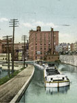
How would the Erie Canal have changed your life and the lives of those around you? Politics, trade, and the land itself were all affected.
This lesson from Teachers’ Domain examines how the construction of the Erie Canal affected the geographic, economic, and political landscape of the United States. In exploring these issues, students are presented with four computer-based activities.
The first two activities—viewing documentary video clips—are engaging, brief, and informative. These clips could be projected to the whole class if a teacher does not have access to multiple computers.
The third—an interactive graphic organizer—allows students to categorize different consequences of the construction of the Erie Canal in terms of geographic, political, and economic effects. The interactive graphic organizer allows students to draw connections between consequences in different categories and explain how they are interconnected in a pop-up comment box. After they are done, students can print out the graphic organizer.
The final activity in the lesson, which requires students to read and write, can be done either on a computer or not. It asks students to synthesize information from the video clip and a background reading (available in two different reading levels), and students can choose from three different writing assignments.
Yes
Featured video contains interviews with reputable scholars.
Yes
Historical background provided in videos and handouts.
Yes
Students take notes throughout the assignment and write a short essay evaluating the major changes resulting from the construction of the Erie Canal.
Yes
Using evidence from the documentary video and a background reading, students assess and examine the economic, political, and geographic effects of the Erie Canal on the nation.
No
Yes
Two versions of background handout are included for different grade levels.
Yes
A graphic organizer helps students organize their ideas and draw connections between the various effects resulting from the Erie Canal’s construction.
Yes
Students can write an essay on the canal’s effects on America or New York State. Students can write a journal from the perspective of someone who experienced the effects of the Erie Canal five years after its construction.
Yes
No
Requires access to multiple computers, but can be adapted for classroom use in which only one computer and a projector are needed to stream the video.

Thomas Jefferson outlined three motivating factors in his instructions to Lewis and Clark: a search for navigable rivers to span the continent; a quest for Edenic beauty and riches; and the competitive desire to acquire a continental empire. These 180 documents and artifacts interpret 19th-century westward exploration from this perspective. The range of materials is striking. In addition to maps, plans, and charts, the site offers images (sketches, watercolors, etchings, and engravings), texts (letters, diaries, speeches, newspapers, and books), and tools (surveying and medical instruments, cooking utensils, armaments). The exhibit opens with an examination of the "imperial mentality" common to Virginia's aristocratic class in the late 18th century and then focuses on the Lewis and Clark journey. It ends with the subsequent expeditions of Zebulon Pike, Stephen H. Long, Charles Wilkes, John Charles Fremont, and the mid-19th century transcontinental railroad plan that supplanted the search for a water route.

Nearly 4,000 panoramic photographs of cityscapes, landscapes, and group portraits, deposited as copyright submissions by more than 400 companies, are displayed on this site. Panoramic photographs were used to advertise real estate and to document groups, events, and gatherings. Images depict all 50 states, the District of Columbia, and more than 20 foreign countries and territories. Subjects include cityscapes, landscapes, group portraits, agricultural life, disasters, education, engineering, fairs and expositions, industrial scenes, military activities, performing arts, sports, and transportation. Although the images cover the period from 1851 to 1991, the collection centers on the early 20th century. The site includes a bibliography, an illustrated 1,000-word background essay on the history of panoramic photography, and an essay outlining the technicality of shooting a panoramic photograph. Four essays focus on specific photographers: George R. Lawrence (1869–1938); George N. Barnard (1819–1902); Frederick W. Brehm (1871–1950); and Miles F. Weaver (1879–1932).

These varied collections document the history of Los Angeles and southern California. "Digital Archives" offer more than 126,000 photographs, maps, manuscripts, texts, and sound recordings in addition to exhibits. Nearly 1,200 images of artifacts from early Chinese American settlements in Los Angeles and Santa Barbara are available, as is the entire run of El Clamor Publico, the city's main Spanish-language newspaper from the 1850s. Photographs document Japanese American relocation during World War II and photographs, documents, and oral history audio files record Korean-American history. The archive also includes Works Projects Administration Land Use survey maps and Auto Club materials. A related exhibit, "Los Angeles: Past, Present, and Future", offers collections on additional topics, including discovery and settlement, California missions, electric power, "murders, crimes, and scandals," city neighborhoods, cemeteries, Disneyland, African American gangs, and the Red Car lines.