Evaluating the Validity of Information

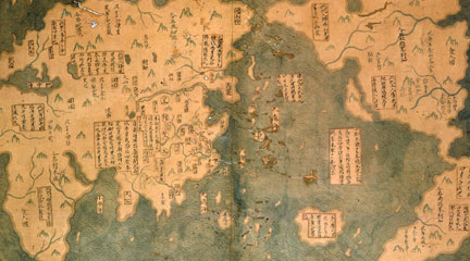
Students learn to assess the validity of a historical argument as they evaluate the implausible theory that the Chinese discovered America in 1421.
TV presents a great deal of historical information these days, but not all of it is valid or trustworthy. Unfortunately, many students lack the tools needed to assess historical information they see on television. This skill-building lesson presents students with some of the tools needed to assess the validity of an argument made through a persuasive, high-quality visual medium. In this two-day lesson, students assess the validity of a claim integral to the argument that the Chinese discovered America in 1421. Retired submarine commander Gavin Menzies presents this argument and the evidence to students in two short video clips highlighting the resources available to ancient Chinese sailors to make seven epic ocean voyages during the Ming dynasty. The lesson is clearly structured and guides students through steps they should take to evaluate historical claims. Helpfully, it includes a student handout that clearly explains the criteria for assessing the evidence of a historical argument. For example students are prompted to look at the qualifications of the person making a claim and to evaluate the persuasive techniques being used. A second handout has a worksheet to help students use the criteria to evaluate specific aspects of Menzies's argument. Student learning is assessed both through classroom discussion and a culminating essay that prompts students to provide a reasoned evaluation of the claim that the Chinese had the naval capacity to travel to America in the 15th century. The lesson includes a detailed rubric to assist your evaluation of these essays.

Yes The process of examining historical evidence is presented accurately. However, other websites present additional information and arguments disputing Menzies' thesis.
No The lesson provides clear criteria for assessing historical accuracy but provides little historical background about the specific time period under investigation.
Yes Students write a final essay, but the lesson does not require significant reading.
Yes Lesson requires students to analyze the evidence.
Yes Requires close attention to the arguments made in a historical video. Attention to the source of a historical argument is an integral part of the lesson.
Yes Appropriate for grades 6-8. Could easily be adapted for grades 9-12.
Yes Provides a well-written student handout of criteria for assessing the validity of a historical argument. A table to help students apply these criteria to Menzies's theory is also provided.
Yes The lesson provides a solid essay prompt and a clear rubric for assessing the essay.
Yes Directions are clear and procedures are realistic in most settings.
Yes The lesson progresses logically toward the goal of making students think about historical evidence.

