Today in History Web Resources

Image
Annotation

Gateway to more than 100 links, most of which provide visitors with the capability to search for events that occurred on specific days. "Specialty sites" link to resources dealing with specific ethnic groups, entertainment forms, politics, professions, regions, and countries. Users can find hundreds of holidays, birthdays of famous people, and calendar-related quotations, as well as links to events involving African Americans, American Indians, popular culture, sports, radical history, psychology, health, and the literary world. No depth, mostly trivia, but still of use to students and teachers who need to check a date.

Virginia Historical Inventory (VHI)

Image
Annotation

Furnishes more than 19,000 survey reports, more than 6,200 photographs, and 103 annotated county and city maps that document the history of thousands of structures built in Virginia prior to the Civil War. Original research was gathered in the late 1930s by the Virginia Writers's Project, a branch of the Works Progress Administration (WPA), and includes information compiled by field workers through onsite investigations—including interviews with residents—and by using court records and other local resources. Provides descriptions of architectural details, histories of buildings, lists of owners, and in many cases photographs and sketches. The project was "specifically charged with describing the vernacular architecture and history of everyday buildings built before 1860: homes, workplaces, churches, public buildings." Also includes materials on cemeteries, tombstones, antiques, historical events, personages, land grants, wills, deeds, diaries, and correspondence.

Provides a 5,600-word essay on the project's history. Users may search reports, maps, and photographs by keywords; includes specific instructions for genealogical research and for finding documents dealing with the Civil War and African American history. Site creators note that many of the structures documented by the project "no longer exist, and the VHI photographs may be the only extant visual records of them." A valuable resource for those studying the material culture of Virginia's past.

The Capital and the Bay, ca. 1600-1925

Image
Annotation

This site offers published books selected from the Library of Congress' general and rare book collections in an "attempt to capture in words and pictures a distinctive region as it developed between the onset of European settlement and the first quarter of the twentieth century." Contains 139 books, a few by well-known figures, such as Edwin Booth, Frederick Douglass, and Thomas Jefferson, but most by little-known residents and visitors to the region. Includes memoirs, autobiographies, biographies, books of letters, journals, poems, addresses, reports, speeches, travel books, sermons, books of photographs, and promotional brochures. In addition to Washington, D.C., the cities of Baltimore, MD, and Richmond, VA, are featured.

A special presentation entitled "Pictures of People and Places from the Collection" consists of selected illustrations organized in three sections of 10 images each on Maryland, the District of Columbia, and Virginia. The site includes 10 works dealing with slavery—a number of which were written by former slaves—and approximately 10 works dealing with encounters between whites and Native Americans. Includes links to 22 related sites. A valuable collection for those studying ways that Washington, D.C., and neighboring regions have been described in print over several centuries.

Heading West and Touring West

Image
Annotation

This site is home to two related exhibits about the exploration and settlement of the American West. "Heading West" is a collection of 15 maps produced between 1540 and 1900 and divided into five categories: imagining, exploring, settling, mining, and traveling. A 700-word essay introduces the exhibit and each image is accompanied by 50-400 words of explanation. The site links to 16 other sites about exploration and maps of the West. "Touring West" is a collection of materials about performers who toured the west in the 19th century. It is divided into five sections: travel, abolitionists, railroads, recitals, and heroics. Visitors will find 3 images in each section and 50-400 words of explanation. The images include prints and photographs of performers, programs, and promotional posters. An introductory essay of 500-words describes the collection. The site offers 15 links to sites about performance. Both exhibits will be useful to those interested in the West, performance, or search of illustrations.

Slave Movement During the 18th and 19th Centuries

Image
Annotation

This site offers downloadable raw data and documentation on 11 topics related to the 18th- and 19th-century slave trade, including records of slave ship movement between Africa and the Americas 1817-1843, the 18th-century Virginia slave trade, and slave trade to Jamaica 1782-1788 and 1805-1808. Data sets contain information such as port of departure, vessel and owner information, number of slaves carried, origins of slaves, and ports of arrival.

Each data set includes a 250-word description explaining bibliographic information, file inventory, and methodology, as well as a codebook that guides users in reading the data. The data is provided without analysis, and the site carries a warning that data analysis is tedious, time-consuming work that requires specialized data sorting software. The site would be particularly useful in controlled assignments for college-level survey or advanced high school students' research into slavery and the slave trade.

Private Passions, Public Legacy: Paul Mellon's Personal Library

Image
Annotation

This exhibit presents 60 items from Paul Mellon's private collection of material relating to the history of Virginia. The entire collection, 447 items, is housed at the University of Virginia. A 600-word essay provides biographical information on Mellon and his bequest. The exhibit is arranged in six sections, from "Exploring the New World" through "Slavery and the Civil War" to "Opening New Vistas". "Acquiring Virginia's Legacy" presents six highlights of the collection and a 1,400-word essay explaining its significance. A 150-word explanatory essay accompanies each image. The exhibit includes facsimiles of 11 books, seven prints, seven letters, five objects of ephemera, and five maps. Among the ephemera is a myriopticon, a rolled painting that viewers can "unroll" to view scenes from the Civil War. The site is primarily interesting as an exhibit and may not be particularly useful for researchers except as an introduction to the Mellon collection.

Pioneering the Upper Midwest: Rare Books c. 1820-1910

Image
Annotation

This American Memory website traces the history of the Upper Midwest (Michigan, Minnesota, and Wisconsin) from the 17th century to the early 20th century, through 138 volumes drawn from the Library of Congress General Collection and the Rare Books and Special Collection Division. Selected works include first-person accounts, biographies, promotional literature, local histories, ethnographic and antiquarian texts, and colonial archival documents that depict the region's land and resources, cross-cultural encounters, experiences of pioneers and missionaries, soldiers, immigrants, reformers, growth of communities, and development of local culture and society. Each work is available in full-text transcription or page image, and is accompanied by notes giving the title, author, publication information, and a 300–350 word summary of the contents.

The site also offers a 2,000-word essay on the history of the Upper Midwest that covers the discovery, exploration, settlement, and development of the region from pre-contact to the early 20th century; a regional map dated 1873; links to more than 40 related websites; and a bibliography of nine related works, three of which are ideal for younger readers. The site can be searched by keyword and browsed by author, subject, and title. For those interested in the history of the Upper Midwest and Great Lakes region, this site offers some informative resources.

The American Revolution and Its Era: Maps and Charts

Image
Annotation

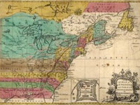
This American Memory site records the mapping of North America and the Caribbean from 1750 to 1789 through images of maps in the Geography and Map Division of the Library of Congress. Most items on the site are also included among the 2,000 images in Maps and Charts of North America and the West Indies, 1750-1789: A Guide to the Collections of the Library of Congress, compiled by John R. Sellers and Patricia Molen van Ee (1981).

Currently the site contains roughly 500 images. Maps and charts will be added to the online exhibit gradually. Selected images include original manuscript drawings by famous mapmakers like Samuel Holland, John Hills, and John Montresor; maps from the personal collections of men like Admiral Richard Howe and the Comte de Rochambeau; and large groups of maps by three major 18th-century London publishers: Thomas Jeffreys, William Faden, and Joseph Frederick Wallet des Barres.

The online collection allows visitors to compare editions, styles, and techniques of mapmakers from Great Britain, France, Germany, Spain, Holland, Italy, and the United States; and to follow the development of specific maps from the manuscript sketch to the finished, printed version. Each image is accompanied by descriptive notes (100–150 words) and a list of the medium, date and place of publication, condition, call number, and repository. The site also includes a 1,500-word essay on mapmaking during the American Revolutionary era and links to 12 other American Memory sites containing related materials.

Visitors can browse this site by geographic location, subject, creator, and title, and can search the site by keyword. This site is ideal for students and teachers interested in mapmaking in the 18th century and in exploring how maps helped to illustrate American culture.

Web de Anza

Image
Annotation

Web de Anza presents material relating to Juan Bautista de Anza's two expeditions into Alta California that resulted in the settlement of San Francisco in 1776. The site is under development, but it is easy to navigate. Visitors will find a 700-word background essay on the historical context of the expeditions and links to seven other sites about de Anza and California history. Primary source material currently includes eight diaries and two letters, available in English and Spanish and indexed by date. This material is supplemented by a gallery of 11 portraits, 14 images of scenery relevant to De Anza's expeditions, and drawings and photographs of nine objects such as a musket of the kind that De Anza probably used.

The site also includes six photographs of re-enactments of events in de Anza's expedition. An Atlas section provides 10 trail route maps, and 20 maps of the area of de Anza's expedition. The site provides useful material for students of California history, religion, and Native Americans at every level, from elementary to graduate school.

The History of Sanitary Sewers

Image
Annotation

Documenting more than 5,000 years of sewage history, this site contains a plethora of sources addressing the historical, cultural, engineering, and even literary aspects of sewers. Beginning in roughly 3,500 BCE and continuing into the 20th century, the site includes a detailed timeline of major sewage developments, as well as links to histories of 14 major cities' sewage systems, including Washington, DC and Los Angeles.

In addition to two histories of the modern toilet, there are more than two dozen articles about aspects of sewage design, including short (500–1,000 word) introductions, engineering text, and even PDF diagrams. As well, there is a feature highlighting the many animals found living in metropolitan sewers and a virtual tour of the Paris, France, sewer system. A bibliography introduces users and researchers to major secondary works on sewage and sewer history. A Miscellaneous area collects literary references to sewers, including works by Robert Frost and Ben Jonson.