A Rising People: Benjamin Franklin and the Americans

Description

During this one-week workshop, workshop fellows will walk the streets and alleys that Benjamin Franklin walked, step through the doorways that he knew, sit in the churches where he worshiped, and stroll around the houses and public buildings where he helped to found the United States. Fellows will also explore the many rooms of Benjamin Franklin's mind: writer, printer, civic leader, politician, diplomat, scientist, revolutionary, founder. They will read Franklin's words—published and personal—and those of other men and women who lived in the era. They will examine the key aspects of gender, of race, of social class, and diverse other topics.

Contact name
Boudreau, George W.
Registration Deadline
Sponsoring Organization
Pennsylvania State University Harrisburg
Phone number
717-948-6204
Target Audience
K-12
Start Date
Cost
Free; $750 stipend
Course Credit
Two types of credit will be available to each educator participating: Institute staff will assist educators in receiving continuing education credit (similar to Pennsylvania's Act-48 requirements). In addition, participants may register for graduate-level credit through the Pennsylvania State University, which will require both participation in all programs of the week-long workshop and additional readings and assignments.
Contact Title
Project Director
Duration
Six days
End Date

Lincoln

Description

Professors Gabor Boritt and Matthew Pinsker examine the War President Abraham Lincoln and the transformation of the United States during and after the Civil War. The seminar focuses on the central role of Gettysburg. Lecture topics include battlefields and soldiers; slavery and race; and Lincoln's transition to a resolute war leader.

Registration Deadline
Sponsoring Organization
Gilder Lehrman Institute of American History
Phone number
646-366-9666
Target Audience
Middle and high school
Start Date
Cost
Free; $400 stipend granted
Course Credit
Pittsburg State University (PSU) is pleased to offer graduate credit to workshop participants at a tuition fee of $199 per credit hour. Participants can receive three graduate credit hours for the duration of the week.
Duration
One week
End Date

The Ways West

field_image
Question

My ancestors migrated in the 1830s from Bradford County, Pennsylvania to Carroll County, Illinois. Is it likely that they used the Erie Canal and the Great Lakes to get there?

Answer

From the early 1830's, emigrants from rural northeastern Pennsylvania traveling to northwestern Illinois had two possible routes that were widely used. The most popular of these was to take the Erie Canal.

A Northern Route

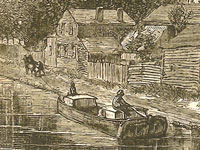
The first route: They would have loaded on a canal boat at Elmira, NY, just north of Bradford County, PA. From there they would have traveled on the Chemung Canal, completed in 1831. This would have taken them up to Watkins Glen at the southern tip of Seneca Lake. At the northern end of the lake in a portage called Geneva they would have picked up the Cayuga and Seneca Canal which was completed in 1830. This would have taken them up to the Erie Canal at Montezuma (near Cayuga), from where they would have traveled west along the Erie Canal to Buffalo. From Buffalo, they could have gone to Chicago via Lake Erie and Lake Michigan (a circuitous route of a thousand miles) on a steamboat. A route that could only be navigated when the lakes were not frozen over in the winter. After about 1833, another possibility was to get off the boat in Detroit (rather than Chicago) where they could have transferred their goods to a wagon or stagecoach which followed the Chicago Road. This path stretched from Detroit to Chicago across Michigan above its southern border and around the south of Lake Michigan.

either of two routes would have been likely

From Chicago, if it was still the very beginning of the decade of the 1830s, they could have floated up the Chicago River and portaged over to the Des Plaines River on a short draft flatboat—or they could have followed the portage route by stage or wagon, depending on the seasonal water level—and from there they could have connected with the Illinois River and floated down to join the Mississippi at Grafton, IL, above St. Louis. From there, they could have taken a steamboat north along the Mississippi to Savanna, IL, in Jo Daviess (later called Carroll) County. However, by the middle of the 1830s, when many new settlers were pushing into Illinois to find farmland, they would almost certainly have taken another route from Chicago, which was the State Road that went more or less directly from Chicago, through Elgin and Rockford, IL, and then ended at Galena, in Jo Daviess County.

A Southern Route

The second route: They could have floated down the Susquehanna River (or used the canal system that supplemented and paralleled the river) south to Harrisburg. They would then have transferred their goods to a Conestoga wagon or a stagecoach, and from there they would have turned west and traveled across south central Pennsylvania by way of the Pennsylvania Road (the Old State Road), which went from Philadelphia to Pittsburgh. At Pittsburgh, they would have transferred their goods to a boat and floated or steamed down the Ohio River to where it joined the Mississippi River at Cairo, IL. Then north by steamboat up the Mississippi to Savanna or Galena, IL (steamboats began regular service between St. Louis and Galena in 1827).

A Third Possibility

Another less probable route existed: Depending on how much they intended to bring with them, they might have considered whether it would be cheaper to travel with their goods to New York or Philadelphia—perhaps by way of the North Branch Canal or the Delaware and Hudson Canal and by toll road—and then to ship to New Orleans. From there to transfer it all to a steamboat bound up the Mississippi River as far as Galena. This may seem like a very roundabout way; however in the early 1830s shipping a lot of freight by road over the mountains of Pennsylvania and across Michigan and Illinois was more expensive than shipping it by water around the Eastern seaboard and up the Mississippi. The completion of the Erie Canal changed the calculation.

shipping a lot of freight by road over the mountains ... was more expensive than shipping it by water
Circumstances Determined Choice of Route

Their choice of route may have taken into account what they intended to carry with them, how much they could spend on their travel, as well as the local conditions along the various routes, insofar as they could foresee them. They would also have considered their strength and health, and whether they could endure pushing a stuck wagon over a mountain road or living in a makeshift tent on the upper deck of a steamship. If they were already farmers and planned on bringing livestock, tools, and household goods to the farmland of Illinois, that would have constrained their choices in a way that prospective miners, who also flocked to the region around Galena, did not experience simply because miners were not likely to have brought any of the tools of their livelihood with them when they moved. In planning their trip, they might have picked up a copy of Illinois pioneer and Baptist missionary John Mason Peck’s, Guide for Emigrants (1836), which recommended routes for prospective settlers from the East and even lists steamboat, stage, and canal fares. Also useful in planning their trip, if they were leaving in 1837 or later, would have been a copy of Samuel Mitchell’s, Illinois in 1837.

For more information

Gerard Koeppel, Bond of Union: Building the Erie Canal and the American Empire. Cambridge, Mass.: Da Capo Press, 2009. William J. Petersen, Steamboating on the Upper Mississippi. New York: Dover, 1995. 1st ed. published in 1937. The New York State Archives’ Erie Canal Time Machine.

Bibliography

John Mason Peck, A New Guide for Emigrants to the West: Containing Sketches of Michigan, Ohio, Indiana, Illinois, Missouri, Arkansas, with the Territory of Wisconsin and the Adjacent Parts. Boston: Gould, Kendall & Lincoln, 1836, pp. 371-381. Samuel Augustus Mitchell, Illinois in 1837; A Sketch Descriptive of the Situation, Boundaries, Face of the Country, Prominent Districts, Prairies, Rivers, Minerals, Animals, Agricultural Productions, Public Lands, Plans of Internal Improvement, Manufactures, &c of the State of Illinois. Philadelphia: S. Augustus Mitchell, 1837. Henry Wayland Hill, An Historical Review of Waterways and Canal Construction in New York State. Buffalo: Buffalo Historical Society, 1908, p. 150. Beverly Whitaker’s website, Early American Roads and Trails for information on the Pennsylvania Road and the Chicago and State Roads. W. B. Irwin, The Routes of Migration between the Atlantic Seaboard and the Midwest. Burbank: Southern California Genealogical Society, 1966.

New Jersey's Quakers and the American Revolution

Teaser

Did you know the Quakers were pre-Revolution abolitionists?...

lesson_image
Description

While many Quakers owned slaves prior to the American Revolution, the Quakers passed a rule in 1758 forbidding their members to buy or sell slaves. This lesson examines how the Quakers' religious views influenced their opposition to slavery during the Revolutionary period. We like that students are asked to analyze a series of primary sources to identify the reasoning behind the Quaker's anti-slavery stance.

Article Body

The lesson plan suggests that teachers begin by delivering a lecture based on an online talk by historian Jean Soderlund. (Adobe Flash Player and Acrobat Reader are required to access the lecture). However, the historian’s lecture is brief, informative, and fairly engaging, so teachers may want to consider playing the lecture for students.

Next, students are asked to read a set of documents written by Quakers in the 18th century, and identify the various reasons Quakers were opposed to slavery. The documents are rich and informative. However, the language is challenging; and teachers may need to modify and shorten the documents, and create guiding questions to help students analyze them.

For an assessment, middle school students create protest pamphlets expressing the reasons behind Quaker opposition to slavery. High school students analyze the Declaration of Independence from the Quaker perspective. High school teachers may want to consider having students also analyze the original draft of the Declaration of Independence which had much stronger language opposing slavery. The original draft of the Declaration of Independence reflects more of Jefferson’s personal views, while the final version reflects more of the consensus view of congress.

Topic
Quaker opposition to slavery during the Revolution
Time Estimate
1-2 days, 90 minutes total
flexibility_scale
4
Rubric_Content_Accurate_Scholarship

Yes

Rubric_Content_Historical_Background

Yes
The plan provides a brief historical overview and a historian's lecture.

Rubric_Content_Read_Write

Yes
Students must read primary sources and respond with a written assessment.

Rubric_Analytical_Construct_Interpretations

Yes
Students read several primary documents to determine the reasons behind Quaker opposition to slavery in the 18th century.

Rubric_Analytical_Close_Reading_Sourcing

Yes

Rubric_Scaffolding_Appropriate

No
The language of the documents may have to be modified—especially for middle school students.

Rubric_Scaffolding_Supports_Historical_Thinking

No
Teachers should consider providing students with a few focusing questions for each document.

Rubric_Structure_Assessment

Yes
There are different assessments for the high school and middle school level. However, no rubrics or specific assessment criteria are included.

Rubric_Structure_Realistic

Yes

Rubric_Structure_Learning_Goals

Yes
A sleek lesson that could be done in one or two class periods.

Pittsburgh City Photographer

Image
Annotation

This photographic archive contains more than 1,500 images commissioned by the Pittsburgh Department of Public Works, Division of Photography, from c1890 through 1973. "The images show Pittsburgh parks, recreation facilities, and athletic events as well as hospital exteriors and interiors, mayoral events, traffic situations, and general street scenes."

The image collection emphasizes interior and exterior photographs of familiar and historic buildings and "interesting depictions of home life, and the famous and not so famous people of Pittsburgh." Each image is accompanied by bibliographic and descriptive information. The archive can be searched by image title, date, creator, location, address, description, or subject. A useful resource for those interested in urban development, city life, and architecture.

Valley of the Shadow: Two Communities in the American Civil War

Image
Annotation

This massive, searchable archive compares two Shenandoah Valley counties during the Civil War period—Augusta County, VA and Franklin County, PA. These two counties were divided by 200 miles and the institution of slavery. Thousands of pages of maps, images, letters, diaries, and newspapers, in addition to church, agricultural, military, and public records provide data, experiences, and perspectives from the eve of the war until its aftermath. The site furnishes timelines, bibliographies, and other materials intended to foster research into the Civil War and the lives of those affected by it. The website includes a section on John Brown and one entitled "Memory of the War," presenting postwar writings on battles, the lives of soldiers, reunions, obituaries and tributes, and politics.