The Bodleian Plate Anonymous (not verified) Mon, 12/22/2008 - 14:43
Description

Architectural historian Carl Lounsbury describes the Bodleian Plate, a copper plate preserving an illustration of Williamsburg in 1747. The Plate has been used as reference in the restoration of Colonial Williamsburg.

To listen to this podcast, select "All 2008 podcasts," and scroll to the August fourth program.

St. Mark's-in-the-Bowery

Description

From the Bowery Boys website:

"St. Mark's-in-the-Bowery is one of Manhattan's most interesting and mysterious links to early New York history. This East Village church was built in 1799 atop the location of the original chapel of Peter Stuyvesant, New Amsterdam's peg-legged director-general.

His descendants—with the help of Alexander Hamilton and the architect of City Hall—built this new chapel with the intention of serving the local farming community of Bowery Village. But in many ways, the more thrilling tales occur among the honeycomb of burial vaults underneath the church, the final resting place of vice presidents, mayors, and even Peter himself.

St. Mark's reflected the changes that swept through Greenwich Village during the 20th century, with experimental and sometimes scandalous church activities, from hypnotism, modern dance and even a trippy foray into psychedelic Christian rock.

ALSO: Find out why you can never EVER go down into the vault of the Peter Stuyvesant. And why is the church IN the Bowery, not ON the Bowery?"

The History Box

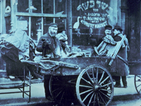
Image
Photo, Pushcart peddler in Lower East Side, NY, early 1900s, The History Box
Annotation

A gateway and an archive of numerous articles on New York history, this site "focuses a particularly long lens on the early history of political and economic events, panics, riots and other related matters affecting or contributing to New York City's development and growth." Its main feature is the New York state and New York City directories. (The U.S. directory is currently unavailable.) The New York state directory offers more than 700 links and more than 60 articles organized under 21 topics that include the arts, cities and counties, ethnic groups, military, societies and associations, transportation, women and their professions, and worship.

The New York City directory offers more than 5,200 links and more than 700 articles organized under 58 topics that include architecture, the arts, business matters, city government, clubs and societies, crime and punishment, education, ethnic groups, 5th Avenue, Harlem, immigration, New York City panics, real estate, temperance and prohibition, and Wall Street. The visitor can search the entire site or each directory by keyword. This site is a good starting point for researching the history of New York. It should also be useful for literary scholars, writers, and historical societies.
Oral History Research Center

Image
Photo, "The Kim Sisters at a table in Reno"
Annotation

Established in 1905, Las Vegas, NV, officially became a city in 1911. Its growth and development over the course of the 20th century is documented through this diverse collection of oral histories. Eight oral histories, in video, audio, and transcript format, expose aspects of daily life in early Las Vegas from the 1930s to the 1960s. Las Vegas showgirls Anna Bailey, Carol Baker, Betty Bunch, Sook-ja, Ai-ja, Mia Kim, and Virginia James discuss working conditions on the Las Vegas strip in the 1960s and 70s as well as their involvement with prominent shows, the racial integration of showrooms, and the growth of the Las Vegas Korean community. Present-day Las Vegas comes to life through oral histories and videos of six women in their 70s and 80s who tap dance together several times a week at the West Las Vegas Arts Center. Segregation, integration, the Nevada Test Site, and local history in Las Vegas are the focus of the oral history roundtable with Rose Hamilton and four other women who grew up together in Las Vegas and remain friends to this day.

Causing the Civil War

Question

Was economic difference—manufacturing in the North and slave-driven agriculture in the South—the primary cause of the Civil War?

Textbook Excerpt

Textbooks have traditionally taught that incompatibility between northern and southern economies caused the Civil War. Everything else was tied to that economic difference, anchored by cotton.

Source Excerpt

Census data from 1860 shows farms, manufacturing, and cities in the North and the South, as well as the location of slaves and cotton in southern states, all of which challenge the notion of a purely agricultural South and industrialized North.

Historian Excerpt

The Civil War was fought for many reasons, not solely or even primarily because of the growing importance of cotton on southern farms. Moving away from economic differences and cotton as simplistic causes leads to a more accurate, and far more interesting, understanding of the causes of the Civil War.

Abstract

For years, textbook authors have contended that economic difference between North and South was the primary cause of the Civil War. The northern economy relied on manufacturing and the agricultural southern economy depended on the production of cotton. The desire of southerners for unpaid workers to pick the valuable cotton strengthened their need for slavery. The industrial revolution in the North did not require slave labor and so people there opposed it. The clash brought on the war.

Economic divergence is certainly one of the reasons for the Civil War, but neither the major one nor the only one. Many factors brought about the war. Focusing only on different economies would be like arguing that one professional football team will always win because it has taller players.

The true causes of the Civil War are downright intriguing and just as complex as the conflict itself.

St. Patrick's Cathedral

Description

From the Bowery Boys website:

"One of America's most famous churches and a graceful icon upon the landscape of midtown Manhattan, St. Patrick's Cathedral was also one of New York's most arduous building projects, taking decades to build. An overflow of worshippers at downtown's old St Patrick's demanded a vast new place of worship, even as most Catholic New Yorkers were having an uneasy time due to religious prejudice by angry 'nativists'.

Enter 'Dagger' John Hughes, the relentless first Archbishop of New York, who hammered the city for equal treatment for Catholics and managed to construct several New York institutions still in existence. Many scoffed at his idea of building a gigantic cathedral so far north of town.

We explore the early years of this once-quiet piece of mid-Manhattan property and some of the notable events that have taken place at St. Patrick's since its opening."

History: The National Park Service

Image
Logo, NPS History and Culture website
Annotation

Historical aspects of many of the 384 areas under the National Park Service's stewardship are presented in this expansive site. A "Links to the Past" section contains more than 25 text and picture presentations on such diverse history-related topics as archeology, architecture, cultural groups and landscapes, historic buildings, and military history. Of particular interest to teachers, a section entitled "Teaching with Historic Places" features more than 60 lesson plans designed "to enliven the teaching of history, social studies, geography, civics, and other subjects" by incorporating National Register of Historic Places into educational explorations of historic subjects. Examples include an early rice plantation in South Carolina; the lives of turn-of-the-century immigrant cigar makers near Tampa, Florida; a contrast between the Indianapolis headquarters of African-American businesswoman Madam C. J. Walker and a small store in Kemmerer, Wyoming, that grew into the J. C. Penney Company, the first nationwide department store chain; the Civil War Andersonville prisoner of war camp; President John F. Kennedy's birthplace; the Liberty Bell; Finnish log cabins in Iowa; and the Massachusetts Bay Colony's Saugus Iron Works. Especially useful for teachers interested in connecting the study of history with historic sites.

Harvesting the River

Image
Color offset lithograph, "Whistling In," Bartlett Kassabaum, 1980
Annotation

Presents a narrative in exhibit format—with hyperlinks to archival documents and photographs—on the cultural and economic life of the people who came to the Central Illinois River region from 1875 to 1950. Organized into three sections on the harvesting of fish, waterfowl, mussels, and natural ice; transportation by boat, railroad, and plank roads; and the settlement and development of six area river towns. The site delivers oral histories (audio and video), as well as illustrations and photographs. It may serve as a useful introduction to those studying this particular region and regional history in general.

Historic USGS Maps of New England

Image
Map, "Mystic, CT-NY-RI Quadrangle," 1944
Annotation

A collection of more than 1,100 topographical maps created by the United States Geological Survey from the 1890s to the 1950s covering all of New England—Maine, New Hampshire, Vermont, Rhode Island, Massachusetts, and Connecticut—and selected areas of New York. The maps—which reveal roads, buildings, rail lines, bodies of water, and elevations—occur in 15-minute and 7.5-minute quadrangle series (a minute is one-sixtieth of a degree of latitude or longitude). In addition, the collection includes six maps with 30-minute quadrangles.

For states other than New York, users can view a state image map and select a point within a grid marked off in 15-minute increments to find listings for available images accompanied by dates the maps were surveyed, created, and revised. Towns within each quadrangle are also listed along with names of adjacent areas. Users also may search an alphabetical list of towns within each state. For New York, only an index of quadrangles names is available. Maps are presented in JPEG format. According to the site, "Each image is typically 2 megabytes, so download times are likely to be slow." A useful site for those studying changes in the New England landscape during the first half of the 20th century.