Massive Resistance Political Cartoons

Video Overview

Historian J. Douglas Smith contextualizes and analyzes two political cartoons commenting on Virginia government's reactions to Brown vs. Board of Education and the call for desegregation.

Video Clip Name
MassRes1.mov
MassRes2.mov
MassRes3.mov
MassRes4.mov
Video Clip Title
Cartoons and Newspapers
Segregation
Looking at the Cartoons
Teaching Massive Resistance
Video Clip Duration
5:05
6:15
5:23
4:33
Transcript Text

These are political cartoons, which typically do appear on the editorial page and are a comment on the major political events of the day. The first cartoon from May of 1954 entitled "Now What," was drawn and published in the immediate aftermath of the Supreme Court’s Brown decision.

Typically, the editorial cartoonists will reflect the editorial position of the newspaper. Certainly in the Richmond Times-Dispatch in the 1950s, the cartoonists would’ve more or less reflected the editorial position of the newspaper. By the time you get to the ’50s, you cannot avoid talking about massive resistance, you can’t avoid commenting on the Brown decision, you can’t avoid commenting on the imminent closing of the public schools. These are single images that convey a quite bit of information. Once you really begin to look deeply at this, you start to understand and to see where Virginia has gone in the four years from the Brown decision.

Virginius Dabney was the editor of the Times-Dispatch from the ’30s until late 1960s. And he recognized that massive resistance itself was not going to lead to anything productive, but the publisher of the paper, the Bryan family, were firm supporters of massive resistance, and so the bargain that essentially was worked out is that Dabney just didn’t say much about massive resistance. He certainly didn’t editorialize against it.

This is actually, I think, quite typical of the elites in Virginia, He was certainly amongst those, but Virginius Dabney once famously described massive resistance as an aberration from Virginia’s heritage of sound leadership and forward-looking thought. So, he was able to sort of dismiss this four- or five-year period as a blip on an otherwise excellent record when, in fact in many, many ways, massive resistance is the logical culmination of a particular type of race relations that people like Virginius Dabney did support.

Dabney is a complicated figure in this in that he was somebody who always editorialized for the better treatment of African Americans in Virginia. But within this paternalistic vein that had developed in Virginia; at one point in time he was seen as a liberal in the '30s because he was advocating better treatment of blacks and anti-lynching. By the '40s he’s more moderate, by the late '50s and '60s he’s actually seen as quite conservative.

Richmond had two papers. There was the Times-Dispatch which was the morning paper and then the News Leader which is the afternoon paper. The editor of the News Leader was James Kilpatrick who was one of the real leaders of massive resistance in many ways. In Norfolk, you have the Norfolk Virginian-Pilot, the other major paper in the state and it was the only one of the white papers that opposed massive resistance. Not that they embraced and desired integration, but that they recognized that the Supreme Court was the law of the land, that the Justice[s] had spoken and it was a responsibility to adhere to those decisions.

The Norfolk Journal & Guide and the Richmond Afro-American were black papers of the time. They were weeklies, and they had a relatively small readership. I think that most African Americans felt they had the Supreme Court ruling on their side and that ultimately that would have to prevail, but getting there wasn’t easy. Richmond was the capital, the power center, and so the Richmond paper certainly was the most important in the state and then the Norfolk paper after that in terms of overall readership.

The 13th Amendment simply abolished slavery towards the end of the Civil War. The 14th Amendment said that no citizen of the United States can be denied the equal protection of the laws. What was so important about the 14th Amendment was that it basically said that any citizen of the United States is first and foremost a citizen of the United States and secondarily, a citizen of their individual state and therefore it meant that no state could deny any individual any of the guarantees that were made by the federal government.

The 15th Amendment said that no person could be denied the right to vote based on race or previous condition of servitude. It doesn’t say that you can’t be denied the right to vote for other reasons, so what you end up with is the implementation of Jim Crow. Because of the 15th Amendment, no state could pass a law which said blacks can’t vote, but what they did instead was come up with all sorts of other methods for achieving essentially the same purpose.

Understanding clauses were educational tests where it was up to individual registrars to decide who passed certain tests. One of the problems with the literacy tests and understanding clauses is that there were in fact many uneducated whites who might have failed those tests. This is where you get grandfather clauses in which states would pass a law which said that if your grandfather could vote, then you can vote. There was no black person whose grandfather could vote because you’re talking about the slave era.

It was under the guise of the 14th Amendment that in Brown, the Supreme Court basically says that the court in Plessy was wrong, that equal protection laws do not allow for segregation. The 14th and 15th Amendment are quite important in terms of understanding the whole edifice of white supremacy and of Jim Crow. It’s not until 1965 with the Voting Rights Act that the vestiges of the disfranchisement laws are finally put to rest.

In the late 19th century you have the implementation of series of state laws, many of them begin with railroad transportation and quickly spread to other aspects of public life. As public schools come into being, they are fully segregated. The segregation laws tend to have to do with public separation of the races in public places.

The whole notion of Plessy v. Ferguson in 1896 when the Supreme Court gives its permission for the South to maintain and build a segregated state. Homer Plessy, who was a man who was one-eighth black, wanted to test the law. The state of Louisiana had passed a law which said that the races could not sit together on railroad cars. He did so anyway. He was arrested, charged with a violation of the law.

The case went to the Supreme Court and by an eight-to-one decision, the Supreme Court said that laws that mandated segregation were okay as long as facilities for both blacks and whites were equal and so the phrase separate but equal comes out of this, talking about parks, playgrounds, schools, trolley cars, then later buses, railroad cars, any sort of place of where the public might mingle.

The standards definition of desegregation is the abolishment of racial segregation and integration, as the full equality of all races in the use of public facilities. A distinction I often find helpful especially in the context of understanding massive resistance, and even more so with what happens after massive resistance is that I think that in many respects desegregation means the end of state-sponsored segregation. Desegregation comes to mean the absolute minimum necessary to comply with the law. What really happens in the wake of massive resistance is that you end up with token integration, at least for another decade until another series of court decisions force more complete integration.

On a national level Brown v. Board of Education was the culmination of a nearly two-decade campaign led by the NAACP to attack segregated education at the professional and graduate school—the whole notion of Plessy v. Ferguson in 1896 when the Supreme Court gives its permission for the South to maintain and build a segregated state.

The NAACP began winning a series of precedents: in the Maryland courts, then Missouri, in Texas, Oklahoma. NAACP recognized that they could keep doing this forever and ever, they basically were arguing that there was nothing equal about segregation, that the states were failing to meet their constitutional mandate under Plessy. The hope was not that they’ll simply increase funding and we’ll have a separate but equal society, but that they would recognize that to do so would be so prohibitively expensive, that real meaningful change would have to take place.

The case of Brown v. Board of Education, which was five cases which all examined the question of segregation in the public schools at the pre-collegiate level—these cases worked their way through the different courts and then finally they were bundled together by the Supreme Court and we know them as Brown v. Board of Education.

In the early ’50s we know Virginia provided one of the cases that was bundled in Brown, the case out of Prince Edward County which started when a group of young students led by Barbara Johns, who was a junior at Moton High School—the facilities in Farmville are horrific and the students finally say enough. Many of their parents are scared because their parents’ jobs depend upon not causing trouble and so the students don’t tell their parents about this. One day they march down to the superintendent’s office and have a protest of their own.

It would be simply wrong to suggest that African Americans in Virginia weren’t demanding more change. Even though the Brown case comes out of Kansas, it’s every bit as much about life in Virginia. People often assume that the Brown decision dealt with segregation and all of its guises and aspects, but the Brown decision actually was limited to segregation in the schools.

Part of the problem with Brown and part of what why we end up with massive resistance is that the court they’re obviously worried about the reaction in the South. So they actually did not in 1954 issue an actual implementation ruling. They could have said all public schools in the South must be desegregated beginning in September, but they did not. They left it up to the district courts and they said they must move with quote unquote “all deliberate speed” and this provides the context for massive resistance.

The NAACP basically said look you’ve got to do this now, or else the white South is going to stall and certainly the NAACP proved to be quite right about this. So, the court decision comes down in May of 1954 and the initial response in Virginia is sort of like this cartoon suggests. The Virginia constitution guarantees every child the right to a public education. So, there were some who thought well maybe if we get rid of that guarantee then we don’t have to run public schools. There were others who thought you know that was going a bit too far. So you have this ferment in the summer or fall of 1954 who are trying to figure out what to do.

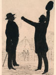
We have an ocean with no land in sight whatsoever, but a giant rock sticking up right in the middle. It says "Supreme Court Segregation Decision," in reference to the Brown decision which declared segregation of the schools unconstitutional. The ship itself is sitting on top of the rock. It’s on the point of the rock so you could imagine if the weight shifted too much one way or the other that it would fall into the ocean. The water itself is pretty still.

The ship is an old wooden vessel labeled The South. Inside the ship there is a schoolhouse. It says public schools. In the front, presumably the captain of the ship is a man that looks like a throwback from the Confederate era. He’s got the trademark long moustache and long, pointed beard. The big top hat, almost a 10-gallon hat except we’re not in Texas but otherwise similar to that. Almost the type of man that you would imagine as a model for Colonel Sanders of Kentucky Fried Chicken fame. This is an old Confederate general, the embodiment of the myth of the lost cause if you will, of the Southern confederacy, and yet here he is in 1954 at the helm of the ship The South standing at the front, but firmly inside the boat, gazing out to sea to look and see whether or not help might be coming.

The overall message is that the Supreme Court decision has put the South in a very difficult spot with regard to the public schools, but disaster is not necessarily imminent. There may yet be a way out of this. The ship is not breaking apart as far as we can see. It’s stuck but not coming apart. The title of the cartoon itself “Now What” suggests some ambivalence about where things are headed.

The Byrds would have to be considered the most prominent political family in Virginia in the 20th century. Harry Byrd, Sr., was the dominant political figure in Virginia from the early 1920s until his death in the mid 1960s. He was elected governor in 1925 as a very young man. Recognized as the head of what comes to be known as the Organization—a small tightly-knit group of important political figures that revolved around the county courthouse the county clerk and the county judge and the county sheriff. He was brilliant at maintaining contact with people, at knowing how to relate with people. People around the state loved Harry Byrd and he was as a governor in some respects progressive for the time, but certainly on issues of race and many others, quite, quite conservative. He went to the U.S. Senate, until 1965 when he became very ill and he actually resigned his seat so that the governor could appoint his son, Harry Byrd, Jr., and then Harry Byrd, Jr., occupied that Senate seat until he retired in 1982.

It’s interesting to note the ways in which the political dynamics of Virginia and the South shifted. Up until the 1960s, Virginia, like every other Southern state, was virtually all Democrats. The Democrats were the party of white supremacy, which makes sense if you think about the Republicans as the party of Lincoln and of Reconstruction. The Democrats regained control in the late 19th century, and it was very much a one-party state until the advent of the civil rights movement when the national Democratic party embraces civil rights beginning in 1948 and then accelerating in the 1960s, you begin to see many southern Democrats switching parties.

A lot of the South was watching to see what Virginia would do. In the fall, the governor appoints what’s known as the Gray Commission in November of 1955. The Gray Commission issues a report. The key provision, and the most controversial one, was a recommendation that the state begin to make available tuition grants so that any white family that objected to sending their child to a school which was integrated could get a tuition grant from the state to go to private school. In January of 1956 the state overwhelmingly voted to amend the Constitution to allow for tuition grants.

The Gray Commission would actually have allowed some integration in places. It was very clear that Arlington especially was ready to integrate its schools. Also, the mountainous parts of Virginia, there’re very few African Americans and they would’ve made financial sense to integrate the schools because running two separate school systems was costly. So the fear was that there were parts of the state that would in fact comply with the court decision and for a lot of people in the southern part of the state, that was untenable.

So, it’s in the spring/summer of 1956 that Harry Byrd and others began to try to formulate a plan and this leads to the real showdown in August and September of 1956 when the governor calls a Special Session of the legislature and what come to be known as the Massive Resistance Laws are passed. The most important components of Virginia’s Massive Resistance Laws were that the people placement was taken out of the hands of local officials and put in the hands of a state people placement board, so that meant that people in Arlington, for instance, could not automatically send to a formerly white school a handful of black students.

Secondly, the Massive Resistance Laws provided for tuition grants. Most importantly, though, what the Massive Resistance Laws did is that they empowered the governor to take control of and close down any schools which integrated as a result of court orders.

On the other side of the issue, there were various people who made very clear that they were more committed to public education than they were to segregation. I think if you had surveyed most white Virginians at the time of the Brown decision they would have preferred to maintain segregation, but that doesn’t mean they’re necessarily willing to defy the Supreme Court. If forced to choose between segregation and public education, they would prefer public education.

The portions of the state, which had the heaviest concentration of African Americans, most of whom were prevented from voting by a variety of reasons, were vastly overrepresented in the Virginia legislature. In the 1956 Special Session when the Massive Resistance Laws were implemented, the key vote in the state Senate was 21 to 17. The 17 who voted against massive resistance actually represented more Virginians than did the 21 who voted to implement the law.

The second cartoon is from late September 1958 and clearly things are quite different. The ship is still intact but somehow it has managed to get off the rock. We have huge waves. There’s massive lightning bolts which appear that they might be headed towards the ship even if they haven’t hit quite yet. The storm is clearly in full force and presumably the waves have risen high enough to pull the ship off of the rocks.

The title "Riding Out the Storm" suggests that there is a way out of this. The fact that the ship has not turned over. It’s still upright. We still have the Confederate-era gentlemen at the helm. He’s now identified specifically as Virginia as opposed to the South. He’s looking out to see what’s ahead, and the presumption is that there is a possibility of still riding out the storm, however severe it now seems to be.

This isn’t a cartoon that has an image of an integrated classroom that somehow leads to some catastrophe. But it certainly suggests that it’s important to maintain segregated schools. Integration is seen as a cause of a storm that’s going to somehow damage or change the way of life.

The character is the same person in both cartoons and yet in the first cartoon, it says "The South," certainly a sense that the South as a whole is sort of stuck looking for a way out, whereas in the second one, it doesn’t say "The South" anywhere. It does say "Virginia" and so in that case it’s more a sense of this is Virginia’s path because by 1958 much of the rest of the South is watching to see what Virginia will do. The message of the first cartoon is that the Supreme Court decision has caused some problems for the South. It’s not entirely clear what’s going to happen next, but what does that actually mean in practical terms.

By 1958, four years later, quite a lot has happened, both on the national level but especially in Virginia. Those who are most committed to keeping the schools segregated have now taken quite a different step. Instead of the ship saying "The South" on the side, it actually now says "public school closing." This is the point just a few weeks before schools actually are closed. There’s still a message here that Virginia can navigate its way through the waters. Despite the Supreme Court edicts, this is somehow a viable strategy to get through this crisis, although it’s become much more problematic.

This was a public relations disaster for the state. Histories of massive resistance are often quick to credit a group of businessmen and bankers in Richmond who quietly said you’ve got to do something to stop this, this is hurting the state’s reputation, it’s hurting business.
I think we should be very careful because these individuals said nothing for four years, so to give them credit for stepping in when they should’ve done so much earlier I think is problematic. By the end of 1958, early 1959, the NAACP and others were challenging the constitutionality of the Massive Resistance Laws in both federal and state courts. In January of 1959, both state and federal courts ruled the Virginia Massive Resistance Laws unconstitutional.

So in the spring of 1959, you have a final showdown between those who want to return to the local option, but with tuition grants, always giving white students the option of getting out of integrated schools at state expense and then those who continued to resist despite all the court decisions. What you really end up with is very token integration. The percentage of black students attending white schools is quite small until the late 1960s. In 1968, the Supreme Court finally said enough of 'all deliberate speed.' It’s been 15 years since the Brown decision.

Start with what appears to be the obvious and then draw out from that what the different components represent. What does this ship represent? What does the person at the helm represent? What is it that’s going on in the sea here? What might the cartoonist not be telling us or not sharing with us? Asking them to explain what do they see here, what do they think is likely to happen?

I think it's important to pay attention to all of the details, to really look at each particular component both on its own and also collectively. See how these pieces fit together. You could look at the cartoons without the caption at the top and it would be interesting to see whether the caption is one that you would necessarily come up with yourself based on the image. In reading any cartoon or any image it's important also to ask what’s not in the picture. And one way you might answer that question is think about how would other newspapers have portrayed the series of events. And in Virginia certainly if you looked at either of the African American newspapers you would have gotten a very different perspective.

The northern Virginian Pilot is the only major white newspaper in the state that opposed massive resistance. And certainly if you were to compare this to cartoons that they had at the time you would see a very different image. They would’ve suggested what they argued editorially, which is that it was doomed to fail. That it could not possibly pass constitutional muster. That by prolonging the inevitable, you’re simply heightening tensions.

It would be very interesting to compare the cartoons with the actual written editorials of those papers. It would be interesting to think about the different ways in which public opinion is reflected. Newspapers aren’t necessarily always accurate. Public documents, to compare what a newspaper is reporting with what the actual public statements are, whether it’s a press release of the governor or looking at the actual laws, looking at election returns. One of the things that’s quite fascinating is to look at private letters, what people are saying behind the scenes. What is the cartoon telling us about the event versus what does it tell us about the person who’s actually created the image. The more sources you can find the better because you’re going to often get conflicting points of view and then it’s important to try to understand those sources in a way that makes those seeming disparities make sense.

John Smith Map

Video Overview

Curator Barbara Clark Smith examines John Smith’s 1612 map of a section of Virginia, asking why Smith included what he did, why he left things out, and what he hoped people who saw this map would take away from it.

Video Clip Name
JohnSmith1.mov
JohnSmith2.mov
JohnSmith3.mov
JohnSmith4.mov
Video Clip Title
Exploring the Map
What is Important?
Different Perspectives
What Questions Can Students Ask?
Video Clip Duration
5:36
6:21
4:15
3:37
Transcript Text

This is a map drawn by John Smith who was one of the first English settlers at Jamestown. And it was first published in 1612 in England. Probably what’s most interesting about the map is just to stop and think: Who did it? Who’s it for? Why is he doing it? What’s he trying to do?

It shows us the worldview of the maker, John Smith, who draws the map. And of the audience, the people in England, members of the Virginia Company, who are investors trying to make money off of this colony of Virginia, who want to hear back that this is a good investment.

It’s a good idea to start out with a few basic orienting things. What’s the orientation? What direction are we coming from? When you look carefully at this map, you’ll see that north is not at the top of the map the way it is in most maps that we’re accustomed to and that most maps at the time in Europe would’ve done. North is to the right. If you stop and think about why that is, it really captures the point of view of somebody looking at the New World from Europe.

How would you approach it? Well, you get a hint with the picture of the ship down in the bottom left. You’re coming on a ship from Europe and this is the European point of view. There are some places, which are named clearly for European figures—Cape Charles, Cape Henry. Jamestown itself, of course, is named for King James. But most of the names are not English names. And this shows how densely populated this area was in the early 17th century by Native peoples.

It tells us something about the style of life in which you live in many different groups with different names. It isn’t clear that all of these Indian groups would’ve thought of themselves as having a common identity beyond owing political allegiance to Powhatan.

Mostly it’s an effort to get information across to the investors in the Virginia Company, who are funding his explorations. The investors did give instructions to the first group of settlers and explorers, saying, “Set up your town and then travel out from there and find out everything.” He’s particularly interested in showing this as a good investment.

He shows the Indian groups that are settled in different areas in order to convince them that there are people there to trade with, people there who can live off of this land. It’s a good land; it sustains life. He’s trying to give them information, but he’s also trying to encourage them to invest more, to have faith in this colony, to support him and the other adventurers. He is trying to be accurate. It’s one of the things you always want to know. How much is this person trying to tell accurate information to the audience. Or are they trying to give a very rosy or maybe a very negative view?

Archeological work confirms that he’s pretty accurate. There seem to be villages where he indicates villages. Maps certainly have to do with laying claim to the territory. Among European powers, the country that has drawn a map of an area does that as part of saying, “this is ours.” Smith isn’t entirely claiming this area. The English have already claimed it, although the Spanish had claimed it earlier.

And as you can see from all the different groups, lots of people claimed it earlier. All these native groups, this is their land. Smith isn’t really contesting at this point whether it’s the Indians’ land or not. Knowledge of where the people are is important in order to understand how much trade can take place in this area.

It says at the top, “Virginia,” although it doesn’t actually cover all the area that the Virginia Company claims to be Virginia.

Powhatan—that’s a name of the chief, but it’s also the name for the group of people who are parts of the empire that Powhatan rules. He’s the leader and he has all these tribes whom he protects. And they pay him tribute, tax, in the form of corn, trade goods, pelts. And that’s what makes him the powerful figure that the English have to deal with.

This helps us understand why it’s limited to this area. It’s not a map of Virginia from the point of view of the Virginia colony and its aspirations to own a great deal more of the continent. And it’s not a map of Jamestown where the English people are settled. It’s a map of Senecomaca, Powhatan’s kingdom.

There’re a couple of answers we come across from the written records. One reason he’s not showing you beyond Powhatan’s area is he’s relying on Powhatan’s Indian guides. They showed him all of the area where they could go freely. When they get to the fall line, you can see that there’re other tribes—the Manahoacs, the Monocans. The Powhatan guides aren’t going to take Smith into enemy territory. So all he can do at that point is take a record and say, “This is where these other Indians are.”

We find out from records of the Virginia Company and letters from Smith and other people in England about what they’re doing and why it’s a good idea to go to Virginia. They’re basing their idea of colonization on what the Spanish did for nearly a century in Mexico and in Peru and in the Caribbean. The Spanish go and find settled Indian groups. They’d like them especially to be rich, like the Incas or the Mayas, to have gold or silver. Then the Spanish conquer them, either through warfare or through diplomatic treaties.

They try to take over at the top so all of the gold, all of the corn, all of the beaver skins, all of the wealth that normally has gone to the dominant chiefs, the Spanish want that to come to them. And they ship that out to Spain. And that’s how they get wealthy. That’s what the English think they’re going to do in Virginia.

It’s an incredibly expensive thing to colonize. The King of England didn’t put up all the money to go settle Virginia, although the King claimed the land. They chartered a private company. In this case the Virginia Company, in which you get investors and they put in money. And they decide to support John Smith and other men who are going to go out and stake a claim and explore what’s there.

The idea of landing in Jamestown is you’ll set up a little town where you can live, and from there you’ll travel out and you’ll find wealth and riches. You’ll find Indian groups with whom you can make alliances. Find out who the important political leaders are. See if you can conquer them or get them to follow you. And see if you can follow the rivers to see if you can get farther into the continent and maybe even to the other side.

Why would Smith want to tell people in England about all these different Indian groups and their names? Aren’t these Indian groups taking up all the land that the English might take up when they come over? And the answer is, initially, that’s not the way the English are looking at it.

They’re looking at it as, “These are people whose wealth we can gain, we can get their crops, the animals they hunt.” And that’s shown up in the map.

In the upper right-hand corner, there’s part of the legend describing what’s on the map. Kings’ houses are a certain size and ordinary houses are another size. Smith is showing there’re all these chiefs and that means this an important political unit. There must be some wealth here. And that’s why this is a good place to settle.

One other aspect of the map that Smith spends a lot of time on is the rivers, showing you the bends and the ups and downs—where it’s wide, where it’s narrow. And that really shows us how he expects the Europeans to enter into the country. They enter in on ships. This is also how they will be transporting the trade goods that they’re getting from these different Indian groups.

It’s very important to the English to think about how they will get wealth back to England. They’re not yet seeing America as, “Here’s a place where we’re going to go and settle and stay.“ Instead, it’s a place we’re going to go, find riches, and return those riches back to England. Some of us may live there on these little outposts such as Jamestown, but most of us will not. And certainly the investors who’re trying to make money, most of them will not actually travel. The closest they get to adventure is reading about it and looking at Smith’s map.

In the upper left is Powhatan, the chief political leader of this time period in this area. It says underneath his name “Powhatan held this state [in] fashion,” meaning he sat and held this meeting in this way. Powhatan is the one with the pipe in his hand. Tobacco ceremonies are part of the diplomacy of the Powhatan people. And he’s got the feathers on his head and he’s wearing some beads or some decoration. And he’s up on a platform. So he’s clearly the big political leader. And beneath him are other people with a fire in this house or building.

The other Indian off to right side is a Susquehannock and he looks rather different. What it says underneath is “The Susquehannahs are a giant-like people and thus attired,” or dressed like this. He’s carrying a bow. He’s carrying a club in his other hand. He’s got an Indian pelt. So he’s depicted as a hunter.

We have here images of two different Indian groups. The suggestion is that one of these groups, the Susquehannahs, are primarily hunters and that what’s important about them is this individual hunting out in the forests. What’s important about the Powhatans is that they are a political group with this important leader.

It’s worth spending some time seeing how different those images are, particularly because we know from other sources that the Susquehannahs also had a political organization. They had chiefs; they had hierarchy. And the Powhatans also hunted. And that was one of the things the English were interested in—how do we get those pelts and furs that might be worth money back in England?

It’s a question that the map presents us with. Why is one group presented this way and the other group presented that way? The map is giving information, but it’s giving selected information about these Indian groups. If we didn’t know from other sources, we might think the Powhatans weren’t primarily hunters or the Susquehannocks didn’t have political institutions.

A choice was made by the mapmaker to emphasize something about these different groups. It tells us that he saw the Susquehannahs in one way, beyond the boundaries of the settled area, out there hunting. And he saw the Powhatans another way, in terms of their political hierarchy.

Powhatan, the paramount chief or political leader of this area, has an idea when the English arrive, too. Which is, “Here’s another tribe; maybe I can add them to the group of tribes with whom I’m allied and to whom I give protection and they will pay me tribute.” So his notion is they may be a useful additional group. They have iron goods. They have guns. They have some really useful things that would make you want to ally with them. They have copper, which is a beautiful good and a good material for making pots that last longer than earthenware. It’s what anthropologists called a “prestige good.” It makes clear that you have access to powers far away. It’s really the same as the Queen of England wearing beaver coats, which show that she has connections and control over the New World.

So from the Powhatan point of view, here’s these new people and they’re kind of interesting. They seem odd because they don’t seem to have any women. It’s hard to understand groups that don’t have women. But I think it’s quite intriguing to think of John Smith on the one hand thinking, “All right, how do I get control of Powhatan and his empire.” And Powhatan thinking on the other hand, “How do I get control of John Smith and his people.” And recognizing that they need help. These are explorers; they’re not farmers. They certainly don’t know how to grow the kind of corn that is grown in North America. The main thing they know how to do is fight and draw maps and explore. The English absolutely need the Indians to help them out.

It certainly isn’t the first place they come to. They come to Cape Charles and Cape Henry and they could’ve gone anywhere up the Chesapeake Bay or any of these other rivers. They go up the river in order to make sure it’s a little bit safer from the Spanish. The Spanish are constantly patrolling the shore of the Atlantic.

Virginia doesn’t really attract the Spanish. They’re happy with their gold from South America and Mexico and the plantation economies in the Caribbean. But they don’t really want the English to get wealthy and become greater competitors. The English know that and they go up the river far enough so they’re not really exposed.

They’re also on the river in case they need to retreat from Indians. Although they expect to be at peace with the Indians and to dominate the Indians, they also know that’s not always going to be true. So they settle right on the water, but up from the coast. It’s deep enough there. It’s not so far up that big ships can’t dock there. Those ships will supply them with food, with tools, and with new settlers. They want to set up a kind of post from which ships will go back and forth to England carrying the wealth that the settlers will be gathering from the countryside.

At the very beginning, it was much less successful than they expected. They suffered immensely from diseases and also they suffered from hunger. There was a drought, so the Indians had less corn themselves than they had normally had to trade and give to the English settlers.

The other aspect was the English settlers were so unprepared to be farmers themselves. They expected both to get food from the Indians and to be able to just gather food from the forest or gather fish from the rivers. And they did do some of that, but it turned out it was a lot harder to live than they thought. So they really needed the support of the Indians.

There was this period historians call the “Starving Time.” You can imagine being an investor in England and thinking this was not a good idea.

Part of the history behind this map is to represent the area as able to sustain life. It’s been a successful settlement so far because we’ve been able to travel throughout and gather this information. Let’s reassure the investors that there’s promise here.

After looking for gold the English try lots of different resources to send back. What they really discover is that tobacco will grow and tobacco becomes this much sought-after item in the 1620s. You can get really rich off tobacco, assuming that you can control enough land and enough labor to work it. Over the next decades, as it turns out that Virginia’s going to become a plantation economy, a society which grows tobacco, it changes the relationships tremendously with the Indians.

Within a couple of decades, there are plantations up and down the James River and it causes great conflict with the different Powhatan groups because those are lands that they use. They may not live on them in settled houses, but they use them for farming or they use them for hunting or they use them to fish along the river.

And the English have no understanding of, or respect for, the Indian’s ideas of ownership and use of the land. So over time, it becomes really clear to the Powhatans that there are more and more English. They’re here to stay. They want more and more land. And so you get a series of wars in the 1620s up through 1640s, when the Powhatans are pushed back.

I would start out with point of view. When you draw the map, you have to stand somewhere and look at the area that you’re mapping. I might ask students where Smith is standing. I guess he’s standing in the Atlantic Ocean or maybe on shipboard. He’s assuming you’re approaching from Europe.

The other thing about every map is it’s a small image of a big area. So the mapmaker had to leave a lot of things out. I would ask what kinds of things got put in and maybe what got left out. For example, we could imagine other things that Smith could’ve put on his map. We could say, well, “Why did he put on the rivers, not roads?” Well, they don’t have roads. There’re certainly paths, but the way you’re going to travel is by water.

He could’ve put on the different kinds of trees or animals that lived here. Or the different kinds of soil. There’re any number of physical features that he could have emphasized. But he was really interested in all these different Native American groups. Students could speculate: Why is that what’s most important or most interesting to the people back in England? Maybe if there had been gold, he would’ve done a map showing that.

You could ask students, to put themselves in the Native Americans’ position. What kind of map would you draw? At the very least it would be turned around, and you’d have some ships coming towards you off the Atlantic instead of sailing away from you. And the English would be this little group over here in Jamestown.

It might not look too different in some ways, but instead of these Indians, they might have images of the English settlers. And it would say, “The English are a giant people and they are thus attired. They carry these odd guns. They have no women.”

Creating a More Perfect Union: 1861-1865

Image
Annotation

During the Civil War, the Survey of the Coast found a new purpose—preparing secret reports on the waters along the Atlantic seaboard to improve Union blockades. This website collects and shares materials from the United States Coast Survey, 1861 through 1865.

You can, for example, read any of nine Notes on the Coast of the United States, prepared by the Blockade Strategy Board. These detail sailing conditions and geography for use by Union captains and generals. Summaries, located under the "Documents" heading, cover the process of creating these lengthy reports.

Additional features include a brief biography of Alexander Dallas Bache, U.S. Coast Survey supervisor; an 1861 map showing slave population density; short overviews of some of the other members of the survey team during the Civil War; and a 33-page PDF concerning the history of the Coast Survey between 1843 and 1867. The PDF contains several maps and photographs.

Using the search box on the main page will retrieve Civil War-era maps of cities, camps, works, battlefields, and more.

Union or Secession: Virginians Decide

Image
Annotation

Created by the Library of Virginia as part of its Virginia Memory project, this website lets visitors explore the events leading up to and immediately following Virginia's secession from the Union on April 17, 1861. Short essays and more than 200 primary sources, including newspaper articles, speeches, letters, prints and drawings, official documents, maps, and other materials, present the story from a variety of perspectives, including those of women, African Americans, and people both pro- and anti-secession.

The website is divided into six different sections, each providing a different way of approaching the content. “Virginians Decide” divides Virginian history from the beginning of 1860 to July 1861 into 12 chronological sections, covering events including the 1860 presidential election, the meeting of the Virginia Convention of 1861, the formation of West Virginia, and the entrance of Virginia into the Civil War. Each section features a 300–500-word essay introducing the topic, accompanied by 5–45 related primary sources, links to the biographies of related historical figures, and 1–3 more short essays looking at aspects of the topic in greater detail. “Explore” lets visitors search all of the site's primary sources by 11 themes (Business and Economics, Convention of 1861, Elections and Politics, Journalism, Making West Virginia, Military, Restored and Loyal Government, Secessionism, Slavery, Unionism, Women) and seven geographical regions.

Visitors can get to know more about the people in the sources in “People.” Forty 400–2,500-word biographies give overviews of the lives of journalists, members of the Convention of 1850–1851 and of 1861, members of the Wheeling Convention, politicians, ministers, escaped slaves, free black businessmen, writers, army officers, slave traders, and others. Each biography includes related primary sources and links to related biographies. “Timeline” lets visitors browse sources arranged on an interactive timeline covering 1849 to 1862, and “For Educators” includes four downloadable lesson plans (on John Brown and the Fugitive Slave Law).

Of special interest to educators is “Callie's Mailbag.” This section gathers together 22 letters sent to a young educated Virginian woman, daughter of a secession-sympathetic Campbell County family. Callie Anthony was in her early 20s when she received these letters, which date from Dec. 1859 to Jul. 1861 and come from relatives and friends, expressing a wide range of pro- and anti-secession views.

Scanned documents and images can be downloaded in high resolution, and transcripts of written and printed documents are also downloadable. A valuable site for anyone teaching Virginian Civil War history, or wanting to give students a closer look at tensions in a seceding state.

Virginia Memory

Image
Annotation

A project of the Library of Virginia, this website makes many of the library's resources available to the public in digital form. Most resources in its digital collections relate to Virginia history, making this a treasure house for educators teaching Virginia state history.

"Digital Collections" contains the bulk of the site's content. More than 70 collections document aspects of Virginian life and politics from the colonial era to the present day, and include photographs, maps, broadsides, newspaper articles, letters, artwork, posters, official documents and records, archived political websites, and many other types of primary sources.

Topics include, but are far from limited to, modern Virgina politics and elections; the 2007 Virginia Tech shooting; World War II photographs; Works Project Administration oral histories; the 1939 World's Fair; World War I veterans and posters; the sinking of the Titanic; stereographs; the Richmond Planet, a 19th-century African American paper; Civil War maps; official documents related to Civil War veterans; religious petitions from 1774 to 1802; letters to the Virginia governor from 1776 to 1784; Dunmore's War; and official documents from the Revolutionary War. Collections can be browsed by topic and title, and are internally searchable using keywords and other filtering tools.

Other features on the site include the "Reading Room," "Exhibitions," and "Online Classroom." "Reading Room" lets visitors explore a primary source for each day in Virginia history or browse a timeline of Virginia history. There are eight essays on unusual sources in the library's collection as well as on new finds in the library's blog, "Out of the Box."

"Exhibitions" preserves 25 exhibits on Virginia history topics that accompany physical exhibitions at the library. "Online Classroom" orients teachers to the site with a short "Guide for Educators," suggesting possible uses for the website's resources, and offers four source analysis sheets and 30 Virginia-history-related lesson plans, all downloadable as .pdfs. The section also highlights two online exhibits designed to be particularly useful to teachers: "Shaping the Constitution," chronicling Virginians' contributions to the founding of the country, and "Union or Secession?", which uses primary sources to explore the months leading up to Virginia's secession in the Civil War.

An invaluable resource for educators covering Virginia state history, this website should also be of use to teachers covering the colonial period, the American Revolution, and the Civil War generally, among other topics.

Massive Resistance through Political Cartoons

Image
Article Body

This website features 4th graders analyzing two political cartoons from the Richmond Times-Dispatch about Virginia's reaction to the Brown v. Board of Education Supreme Court decision. This standards-based lesson guides students in exploring the Virginia state policy of massive resistance to school desegregation. This video provides examples of two promising practices:

  • Modeling careful analysis of a primary source while practicing historical thinking with young students;
  • Using scaffolding and concrete instructional strategies to guide students in shaping meaning out of multiple primary sources.
The Lesson in Action

Video of the lesson shows the teacher modeling primary source analysis with the first cartoon and students working in pairs to interpret a second on their own. Both cartoons—one published in 1954 and the other in 1958—are drawn by Fred O. Siebel. They use similar imagery and symbolism, helping students analyze the second cartoon and compare the two. Through effective scaffolding and modeling of historical thinking skills, the teacher engages students in thinking about complex historical questions of equality, fairness, and the power of federal and state governments. The lesson concludes with a class discussion of each group's findings and what their analysis means in relation to Virginia and public school desegregation.

Through effective scaffolding and modeling of historical thinking skills, the teacher engages students in thinking about complex historical questions of equality, fairness, and the power of federal and state governments.

This lesson comes at the end of a unit on civil rights, segregation, desegregation, and massive resistance in Virginia. Students at this point have an understanding of segregation, Jim Crow laws, and the individuals Thurgood Marshal and former Virginia Governor Harry F. Bird, Sr. The teacher uses primary sources in this lesson to assess and review students' understandings of school desegregation and Byrd's Massive Resistance response to the Supreme Court order to integrate schools. At the same time, she engages students in thinking about historical questions of fairness, equality, and reactions to change. You can find a comprehensive lesson plan, complete with primary sources, background information, and classroom worksheets, on the website.

Reston Collection Images

Image
Annotation

This collection of more than 160 texts, maps, photographs, and sketches is focused on the people, themes, and organizations important to Reston's history as a planned community. Textual materials include deeds, certificates, promotional brochures, studies, reports, and correspondence. Maps include Reston's Master Plan, major road systems, educational facilities, and recreational areas. Photographs include Lake Anne, various physical structures, and people significant to Reston's history. Sketches are mostly of building and community plans. Subject areas include health care, education, public services, parks, recreation, transportation, and population.

The collection can be browsed by title, subject, people, or organization and it can also be searched by subject, personal name, corporate name, or title. This is a website of interest to those researching the history of Reston or of planned communities.

The Story of Virginia

Image
Annotation

This attractive website offers a presentation on the history of Virginia from prehistoric times to the present with essays, images, and teaching resources. There are 10 chapters: the first Virginians; the settlement of colonial Virginia; Virginia's society before 1775; Virginians in the American Revolution; Virginians as Southerners, Confederates, and New Southerners; Virginians in the 20th century; the struggles of African American and female Virginians for equality; and a final chapter on images of Virginia in popular culture. Each chapter has an essay featuring images of relevant items in the collections of the Virginia Historical Society.

The "resource bank" collects all 95 images from the chapters of people, documents, places, and objects. Additionally, the site offers a teacher's guide for each chapter listing the standards of learning, a summary of key points, classroom activities and lesson plans, links to related websites, and information on tours, outreach programs, and hands-on-history programs.

An excellent introduction to the history of Virginia and its people with useful resources for class projects and classroom instruction.