U.S. Marine Corps

Article Body

The United States Marine Corps acts as the initial military respondent, via air or sea, to international disaster scenes and threats to U.S. interests.

Compared to the other four military branches, the Marine Corps history offerings are decidedly limited. However, a small selection of resources may be relevant for K-12 education.

A interactive timeline breaks the history of the Marines down into periods under different leaders, major innovations, and battles in which the corps has participated. The official site also offers back issues of Marines magazine, beginning with 2005.

If you are interested in the social history of the Marines, brief descriptions of their major symbols or their lore are the best resources available. Note that some features are covered in both sections.

A national museum of the Marine Corps also exists in Triangle, VA, if a field trip is in store. Tours are not offered, but the website does make gallery worksheets available.

Race and Place

Image
Annotation

This archive addresses Jim Crow, or racial segregation, laws from the late 1880s until the mid-20th century, focusing on the town of Charlottesville, VA. The theme is the connection of race with place by understanding the lives of African Americans in the segregated South. Political materials includes seven political broadsides and a timeline of African American political activity in Charlottesville and Virginia. Census data includes searchable databases containing information about individual African Americans taken from the 1870 and 1910 Charlottesville census records. City records includes information on individual African Americans and African American businesses. Oral histories includes audio files from over 37 interviews. Personal papers contains indexes to the Benjamin F. Yancey family papers and the letters of Catherine Flanagan Coles. Newspapers, still in progress, includes more than 1,000 transcribed articles from or about Charlottesville or Albemarle from two major African American newspapers—the Charlottesville Recorder and the Richmond Planet. Images has links to two extensive image collections, the Holsinger Studio Collection and the Jackson Davis Collection of African American Educational Photographs, and three smaller collections.

Using Maps as Primary Sources

Image
Article Body

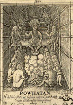
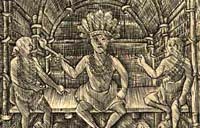
This website shows a 4th-grade teacher in northern Virginia teaching a lesson focused on a map drawn by John Smith that was published in 1612. Source Analysis, a feature created for the Loudoun County (Virginia) (TAH) website, has three sections focused on this primary source: scholar analysis, teacher analysis, and classroom practice. The latter two sections show a standards-based lesson that asks students to answer the question: What is important to John Smith? The teacher carefully plans activities so students look closely at the map and consider how this primary source helps them answer the central question. The site provides examples of two promising practices:

  • Engaging young students in close, careful observation and reading of a primary source document (using student pairs and a comparative document); and
  • Using students' observations to inform and guide analysis and connect the source to larger questions and topics in the curriculum.
The Lesson in Action

In the Classroom Practice section, we see the lesson in action. The teacher introduces the lesson question and then takes time to ensure that students understand the question by introducing synonyms for "important" and reviewing word meanings. She passes out the maps to assigned student pairs and asks them, "What do you see?" Students have time to look carefully at the map and notice words (e.g., "Jamestown" and "Powhatan"), the Chesapeake Bay and its tributaries, living structures, trees, how particular words vary in size and spacing, and so on. The teacher further facilitates the students' observation by juxtaposing the 1612 map with a contemporary textbook map of the same region. This juxtaposition helps students see the choices John Smith made in drawing this map that they might have missed without the comparative source. The teacher then uses what students notice about these maps to help them think about what the details and differences mean. Students start to identify what was important to John Smith and subsequently to the Virginia Company, given the evidence in front of them. Throughout this instruction, the teacher uses feedback, a logical sequencing of activities, and clear and accessible questions to ensure access to the learning activities for all of her students.

Thinking Like Historians

This teacher shows how carefully structured lessons that use primary sources can engage students in the process of thinking like historians. Students slow down and carefully read and look at the map, noticing things that they might otherwise have missed. They then consider what the contents of the map mean and what the map tells us about John Smith and the Virginia Company's worldview. The 1612 map becomes a window into the past that only reveals its slice of the landscape with close reading. Also on this site is a Teacher Analysis section in which the teacher explains some of what preceded this lesson and her instructional choices—a useful complement to the classroom videos. Each of these sections presents information in a set of videos that are clearly titled and visually interesting.

Virtual Jamestown

Image
Annotation

This is a good place to begin exploring the history of Jamestown. The site includes over 60 letters and firsthand accounts from 1570 to 1720 on voyages, settlements, Bacon's Rebellion, and early history. More than 100 public records, such as census data and laws; 55 maps and images; and a registry of servants sent to plantations from 1654 to 1686 complete the site.

Virtual Jamestown also includes records from 1607 to 1815 of Christ's Hospital in England, where orphans were trained to apprentice in the colonies. There are four interactive virtual recreations. The reference section includes a timeline from 1502 to the present, narratives by prominent historians, links to 20 related sites, a bibliography of primary and secondary sources. The Complete Works of John Smith and John Smith's Map of Virginia have recently been added to the site, while 3D recreations of Jamestown's Statehouse and Meetinghouse as well as an archive of Virginia's first Africans are being added.

Valley of the Shadow: Two Communities in the American Civil War

Image
Annotation

This massive, searchable archive compares two Shenandoah Valley counties during the Civil War period—Augusta County, VA and Franklin County, PA. These two counties were divided by 200 miles and the institution of slavery. Thousands of pages of maps, images, letters, diaries, and newspapers, in addition to church, agricultural, military, and public records provide data, experiences, and perspectives from the eve of the war until its aftermath. The site furnishes timelines, bibliographies, and other materials intended to foster research into the Civil War and the lives of those affected by it. The website includes a section on John Brown and one entitled "Memory of the War," presenting postwar writings on battles, the lives of soldiers, reunions, obituaries and tributes, and politics.