Journals of the Lewis and Clark Expedition

Image
Image, Page from the journals, Journals of the Lewis and Clark Expedition
Annotation

This well-designed site presents the Nebraska edition of the Lewis and Clark journals, edited by Gary E. Moulton. The site provides the complete text of all the journals from the 1803–1806 expedition, as well as introductions, prefaces, and sources. The material is searchable by keyword and phrase.

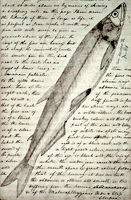
There are 29 scholarly essays about the expedition. An image gallery offers 124 images of pages from the journals, 95 images of people and places, and 50 images of plants and animals encountered on the expedition. The maps section includes 12 explanatory maps and nine images of maps from the journals. Additionally, there are 27 audio excerpts of journal readings and eight video interviews with the editor of the project. The website stands as an outstanding resource for researching the history of the Lewis and Clark expedition.

American Notes: Travels in America, 1750-1920

Image
Title graphic, American Notes: Travels in America, 1750-1920
Annotation

This site is a collection of 253 travel narratives written between 1750 and 1920. The narratives were written by American citizens and foreign visitors about their travels in America. Some of the accounts were written by famous Americans (James Fenimore Cooper and Washington Irving, for example), but most of the authors were not famous. The narratives include their observations and opinions about American people, places, and society; and are valuable sources for the study of early American attitudes. Most accounts are viewable either as scanned images or as transcribed texts. Also included is the 32-volume set of manuscript sources entitled Early Western Travels, 1748-1846. The collection is searchable by keyword, and may be browsed by subject, author, and title. Students and teachers will find these primary sources invaluable for research and study of the late 18th and 19th centuries.

Digital Map Collection

Image
Map, Marine protected areas in the Gulf of Maine...
Annotation

This specialized site contains more than 6,000 digitized maps. Almost 700 are maps of California, most drawn in the mid-19th century. California map results can be sorted according to users' needs. More than 5,330 maps (primarily from the 19th and 20th centuries) cover other parts of the world, including Portugal, Kenya, Hong Kong, Iraq, and hundreds of other nations or territories. Non-California search results cannot be sorted. Many of the maps are archived by the University of California, Berkeley, but some are accessible by links to other sites.

The maps are extremely high quality, so loading the images may take some time, especially with slower connections. The maps include information about the date and author. The site is difficult to navigate and the search engine is finicky, but the site should be useful to those interested in high-quality maps, especially older ones. This site will be most useful for those who are looking for specific maps.

Lewis and Clark: Maps of Exploration 1507-1814

Image
Logo, Lewis & Clark, The Maps of Exploration
Annotation

This 1995 exhibition presents approximately 70 maps designed to help "understand [Thomas] Jefferson's views of the West and the nature of the quest to the Pacific," and to "show the evolution of cartographic knowledge of North America up to the time that [Meriwether] Lewis and [William] Clark set out."

Arranged into five sections, it treats the period from the arrival of Columbus in North America to Lewis and Clark's 1803 voyage.

Well-written background essays describe relevant monographs and journals, explain the role of technology in mapmaking, and elucidate the social and intellectual contexts of Western exploration.

The site, which offers both European and American perspectives, also furnishes eight related links and a 31-title bibliography.

Particularly useful for understanding the evolution of geographic knowledge about North America and for tracing the history of cartography during this period.

Envisaging the West: Thomas Jefferson and the Roots of Lewis and Clark

Image
Image for Envisaging the West: Thomas Jefferson and the Roots of Lewis and Clark
Annotation

By the time Thomas Jefferson became the third President of the United States in 1801, interest in exploring the West had begun to shape U.S. policy. This chronological narrative traces Jefferson's life, participation in politics, and accumulation of scientific geographical knowledge from 1735 to 1804. There are four main sections: "The Jeffersons and Their Frontier Virginia Neighborhood," "From Colony to Commonwealth," "Science and Statecraft at Home and Abroad," and "Public Servant to the Early Republic."

This narrative is accompanied by an archive of 169 letters, statues, books, treaties, maps, and journals providing primary source insight into Jefferson's thoughts about the West and the Lewis and Clark expedition in particular. Three interactive maps from the 1700s, overlaid with historical data about cities, private dwellings, natural features, courthouses, and waterways, provide important insight into the geographic and social environment at the time.

Historic Topographic Maps of California

Image
Map, San Francisco 15-minute Quadrangle, 1895
Annotation

Provides historical United States Geological Survey maps of the San Francisco Bay area, from Point Reyes in the north to Half Moon Bay, and east to San Jose. Includes maps from different time periods—the earliest is from 1895, the latest 1997—covering each 7.5-minute and 15-minute quadrangle of the area. Users may zoom in to see minute details. Searchable by quadrangle or place name. Of value for those studying change over time in the development of the Bay Area during the 20th century.

Historical Maps Online

Image
Map, D.B. Cooke & Co.'s railway guide for Illinois...
Annotation

This website offers more than 400 images of historic maps charting 400 years of development in Illinois and the northwest territory. The collection of maps can be browsed by state or geographic area or by categories such as early maps, topographic maps of Illinois, Indians of North America, waterways, and transportation. Types of maps include maps showing roads and canals, topographical maps, French and Spanish colonial maps, maps of railways, city maps, county and township maps, maps showing regions of settlement, and sectional state maps.

A zoom and pan feature allows the map images to be examined in detail and bibliographic information is provided with each map image. A keyword search is available. An excellent source of historic maps.

U.S. Geological Survey

Article Body

The U.S. Geological Survey exists as a federal organization created to study the nation's flora, fauna, biology, geography, bodies of water, geology, and geospatial information.

The USGS provides access to their entire photographic collection, which is sub-divided into portraiture, photographers, "pioneer photographers," and images of earthquakes; mines, mills, and quarries; national parks; and Mt. St. Helens.

In addition, educators can access nine sub-sites and resources optimal for K-6 education, covering land use and exploration. Sample topics include "A Satellite View of the Journey of Lewis and Clark" and "Urban Growth in American Cities." Twelve resources, also addressing land use and exploration, are available for grades 7-12.

Available teacher packets, like the majority of the site, will primarily be of use to science educators. However, the three packets on maps could be used in conjunction with units on westward expansion or exploration.

Pearl Harbor Attack Map

Image
Avenge Pearl Harbor, Our Bullets Will Do It, c.1942-3, NARA, Flickr Commons
Annotation

This interactive website on the attack on Pearl Harbor provides a chronological overview of the day's events. Each major event on the day's timeline is shown on a map of Hawaii, giving the events a visual place within the harbor geography and allowing site visitors to see where ships were in relationship to each other.

On the map, each major occurrence can be selected as the "full story." These individual full story pages provide a short textual overview of the event alongside a looping archival image and video slideshow. Clicking progresses through the slideshow for users interested in quickly revisiting an image after it has passed or who simply want to go through the slideshow at a faster pace. Many of the events also offer eyewitness quotes.

One of the most praiseworthy aspects of the site is that these quotes are not all from U.S. sailors and commanders. The voices selected include two women—a nurse and the daughter of a military man—and several Japanese airmen, submariners, and commanders. By providing voices from both sides of the attack, National Geographic avoids dehumanizing the Japanese through the absence of their own stories.