Indian Health Service
Article Body

According to the Indian Health Service website, the organization's mission is "to raise the physical, mental, social, and spiritual health of American Indians and Alaska Natives to the highest level." This is accomplished by serving as the primary health caregiver for these populations and through a direct relationship to both the federal government and tribal organizations.

Every year you teach students about Native American history; but, while everyone knows that the British, U.S. citizens, Spanish, and French still abound, do your students know that Native American tribes are still active today? One way to increase student interest in Native American history might be to show how their past treatment is still relevant to the status of today's Native American groups. Yet another possible benefit of addressing their modern lives is the bridging of the conceptual gap between social studies years of civics and American history.

The main offerings of use to educators on the Indian Health Service website are statistics and photographs.

The statistic sets which can be found include an overview of health disparities, as well as additional short sections focusing on diabetes, HIV, behavioral health (drug use and suicide), and death by injury. The Division of Program Statistics also offers publications on national and regional health trends and mortality, population, and special reports on Alaska natives. Special reports include statistics for specific demographic populations, such as children or the elderly.

Most historically-minded of the site's offerings, the photo gallery is extremely easy to navigate. You are first asked to select an image category: "Administrative," "Ceremonial," "Clinical," or "Public Health." From there, you select a more specific image content subcategory and a time period. Time period options include historical images (1887-1969), all time periods, or individual presidential administrations. The end result is that you don't have to spend any great amount of time to find precisely the image that you want. This is the sort of image gallery you'll wish every site had.

History of Presidential Elections Site

Image
Logo, HistoryCentral.com, United States Presidential Elections
Annotation

Provides statistics on all U.S. presidential elections. For each election year, the site presents graphs showing popular and electoral votes, maps of states won by each candidate, vote count and voter turnout statistics, and a sketchy essay of approximately 100 words in length on campaign issues. Offers more extensive information on the 2000 election: official certified results; polling data by five organizations from August through October 2000; biographical statements of 300-600 words each on candidates George W. Bush,Al Gore, and Ralph Nader (the Bush bio, almost twice the length of the others, reads as if it was written by his campaign organization); a chronology of events following the election until Gore's concession; and the Bush v. Gore Supreme Court decision, concurrence by Chief Justice Rehnquist, dissents by Justices Breyer, Souter, and Stevens, and oral arguments. Also includes an essay of 900 words on close and disputed elections, with links to "quick facts" about the candidates involved; an essay of 600 words about the reasons that the electoral college was created, with a link to Federalist Paper No. 68 by Alexander Hamilton, which offers a rationale for the institution; and a 15-minute multimedia history of the Supreme Court. MultiEducators of New Rochelle, NY produces multimedia software on historical subjects; graphs and texts in this site have been taken from their American History CD-Rom. A useful source for statistics on presidential elections, but marred by intrusive flashing ads.

American State Papers, 1789-1838

Image
Logo, Readex
Annotation

This subscription-only website presents an extensive archive of U.S. history documents, offering roughly 6,300 publications. The archive provides access to every Congressional and Executive document of the first 14 U.S. Congresses, and additional coverage through the 25th Congress, as well as tables, maps, charts, and other illustrations. The collection is particularly strong in military history, with 205 documents about military bases and posts and 134 on military construction. Other documents address topics such as westward expansion, Native American affairs, and issues surrounding slavery. This collection also includes numerous speeches and messages by Presidents Washington, Adams, Jefferson, and Madison.

Users can browse the archive by category: Subjects, Publication Category, Standing-Committee Author, Document Class, and Congress. Simple and advanced searches are available, enabling easy access into this large collection of documents. For those with access, this site is a valuable resource for researching the government and military in the early United States.

Curating the City: Wilshire Blvd

Image
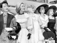
Photo, Prize-winning fashionable women at Beverly Wilshire Easter brunch, 1955
Annotation

Wilshire Boulevard runs for 16 miles in Los Angeles, from Ocean Avenue in Santa Monica to Grand Avenue in Downtown. This website offers an interactive journey down the length of this historic street, with more than 100 stops at parks, buildings, and historic landmarks in Westwood/Brentwood, Beverley Hills, Miracle Mile/Carthay Circle, Windsor Square/Hancock Park, Wilshire Center, and the Parks District.

Virtual visitors to Palisades Park in Santa Monica, for example, can see 14 photographs and drawings of the park, spanning from the early 1900s, through the 1940s, and to contemporary photographs, and read a brief description of the park's history. Those interested in the history of architecture will find useful a website feature that allows users to filter all monuments by architect, style, and function. The website also includes a "Memory Book," allowing users to contribute their stories about Wilshire Boulevard and read the stories of others, as they talk about their favorite pizza restaurant in Westwood or their childhood in Beverly Hills in the early 1960s.

Seattle Power and Water Supply Collection

Image
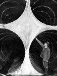
Photo, Man standing in completed penstock. . . , 1925, University of Washington
Annotation

This collection features images of dams, hydroelectric power plants, and water supply facilities built in Washington State from the late 1890s to the 1950s. The archive contains 695 items, primarily photographs but also some maps, diagrams, and other documents. A book excerpt on Washington's public water projects from Building Washington: A History of Washington State Public Works (Seattle, WA: Tartu Publications, 1998) by historians Paul Dorpat and Genevieve McCoy provides perspective on the photographs. The collection is notable because "many of these dams, power plants and reservoirs were built in some of Washington's most rugged terrain and had features that represented significant engineering feats of their time." Each image is accompanied by full descriptive and bibliographic data.

The site offers three ways to search the archive of photographs: keyword search, search by collection, or an advanced search option by selected fields and subjects. Or the visitor can browse all the items by selecting "view all items" in the search drop-down menu. This website is a useful resource for those interested in the history of Western hydroelectric dams and other water projects in the first half of the 20th century.

The Oregon Encyclopedia

Image
image of an explorer overlooking an Oregon lake
Annotation

This website is a collaboration between Portland State University, the Oregon Council of Teachers of English, and the Oregon Historical Society, and is a key project of the Oregon Sesquicentennial Celebration. Beyond its basic function as a reference tool, The Oregon Encyclopedia provides lesson plans for teachers—primarily for grades 4–12. The site is divided into 17 categories, each one with several subcategories such as "biography," "event," "group," or "place." Entries include a brief history, or synopsis, of the topic with any accompanying media objects and suggested reading. Entries are arranged alphabetically or by topic with a search engine that allows searches based on category, theme, sub-theme, county, era, or region. Each week new entries are added to the hundreds currently online.

In the For Teachers section, users will find several sections. "History Minutes" contains facts about important topics related to the state. The "Oregon IQ Test" offers a short list of Oregon trivia questions. The "Permissions" and "How to Cite" pages outline the educational and fair use policies to help students navigate copyright policies. Under "Research Tools," users will find a list of annotated bibliographies, as well as the ability to conduct a live chat with an online librarian any time of day—even during the weekends.

Oregon and U.S. history teachers and students will find The Oregon Encyclopedia a useful resource for learning more about the nation's 33rd state and its role in U.S. history.

Mexican-American War and the Media

Image
Image for Mexican-American War and the Media
Annotation

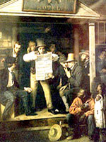
These more than 5,500 transcribed newspaper articles related to the Mexican-American War represent five newspapers from the U.S. and England. They span the period from 1845, when the U.S. annexed Texas, through 1848, when Mexico surrendered and the Treaty of Guadalupe Hidalgo was signed.

The contrast between coverage of the war in the U.S. and England is particularly striking. The Times of London fulminated against the immorality of slavery and of the southern scheme to annex Texas as a slave state, while exposing America's imperialist ambitions as, among other things, an attempt to shore up the nation's fragile stability through the escape valve of western migration. By contrast, newspapers from Maryland and West Virginia did not examine the issue of slavery in the articles included here.

Some images and links to watercolor and print collections are also available. The website provides a comprehensive bibliography on the war, but offers little historical background or contextualization beyond links to related materials and an expanded timeline.

"Join or Die"

field_image
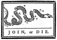
woodcut, 1754, Benjamin Franklin, Join or Die, org. pub. in Pennsylvania Gazette
Question
Why aren't Delaware and Georgia included on the body of Ben Franklin's famous "Join or Die" snake? And why did the artist combine the four northeastern colonies as one?
Answer

The "Join, or Die" snake, a cartoon image printed in numerous newspapers as the conflict between England and France over the Ohio Valley was expanding into war—"the first global war fought on every continent," as Thomas Bender recently has written—first appeared in the May 9, 1754 edition of Benjamin Franklin’s Pennsylvania Gazette. The image displayed a snake cut up into eight pieces. The snake’s detached head was labeled "N.E." for “New England,” while the trailing seven sections were tagged with letters representing the colonies of New York, New Jersey, Pennsylvania, Maryland, Virginia, North Carolina, and South Carolina. The exhortation "JOIN, or DIE" appeared underneath the image.

Lester C. Olson points out that Franklin might have seen images of snakes divided into two segments that had been published in Paris in 1685, 1696, and 1724 with the similar caption "Se rejoinder ou mourir." The image in the Pennsylvania Gazette followed an article reporting the recent surrender of a British frontier fort to the French army and purported plans of the French, with their Indian allies, to establish a massive frontier presence with which to terrify British settlers and traders. The article ended with the surmise that the French were confident they would be able to "take an easy Possession of such Parts of the British Territory as they find most convenient for them" due to the "present disunited State of the British Colonies" and warned that the French success "must end in the Destruction of the British interest; Trade and Plantations in America."

Franklin was opposed in his efforts to unify the colonies by representatives of some of the colonial assemblies

A longtime advocate of intercolonial union in dealings with Indians, Franklin helped make such a union an important agenda item for the Albany Congress, convened shortly after the snake image was published, on earlier orders from the Board of Trade, the British advisory council on colonial policy, with the goal of establishing one treaty between all the colonies and the Six Nations of Iroquois. As a commissioner to the congress appointed by the governor of Pennsylvania, Franklin was opposed in his efforts to unify the colonies by representatives of some of the colonial assemblies intent on maintaining control over their own affairs.

Robert C. Newbold has speculated that Georgia was probably excluded from the snake image, "because, as a defenseless frontier area, it could contribute nothing to common security." Only three laws had been passed in Georgia since its founding as a colony in 1732, prompting a historian of the colony and state to conclude, "The hope that Georgia might become a self-reliant province of soldier-farmers had not succeeded, and even the early debtor-haven dream had not come to pass." Delaware, Newbold added, "shared the same governor, albeit a different legislature, as Pennsylvania; hence the Gazette probably considered it as included with Pennsylvania."

As with the snake image, the Albany Plan, drafted during the congress, did not include Georgia and Delaware in its proposed colonial union for mutual defense and security, specifying only Massachusetts Bay, New Hampshire, Connecticut, Rhode Island, New York, New Jersey, Pennsylvania, Maryland, Virginia, North Carolina, and South Carolina. The segmented snake image was revived in a number of newspapers during the 1765 Stamp Act conflict, again without reference to Georgia and Delaware. In 1774, when the segmented snake image, along with the "Join or Die" slogan, was employed as a masthead for newspapers in York, Massachusetts, and Pennsylvania, a pointed tail labeled "G" for Georgia had been added.

Bibliography

Thomas Bender, A Nation Among Nations: America’s Place in World History . New York: Hill and Wang, 2006.

Lester C. Olson, Emblems of American Community in the Revolutionary Era: A Study in Rhetorical Iconology Washington: Smithsonian Institution Press, 1991.

Albert Matthews, "The Snake Devices, 1754-1776, and the Constitutional Courant, 1765," Publications of The Colonial Society of Massachusetts, Volume XI: Transactions, 1906-1907.

Library of Congress. "Join or Die". Accessed February 25, 2011.

California Labor History jmccartney Wed, 09/09/2009 - 17:12
Image
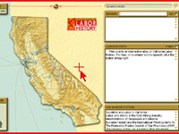
Image, Introductory graphic, California Labor History
Annotation

This interactive essay covers 300 years of labor history in California. Powered by Shockwave, the site features a map of California that depicts the locations of labor disputes from 1776 to 1992. Using the scrollbar at the top of the site, users can change the year displayed on the map. On the map itself, small dots indicate the location of a particular event important to California's labor history. Clicking on the dot reveals a chronological list of related "Labor Events." The bottom-left panel, titled "Bigger Picture," provides links to sections of a larger secondary source entitled "Contextual Information" on California labor history relevant to the year and location the user is viewing. 64 700-word essays are mainly excerpts from published books and articles.