Web de Anza

Image
Annotation

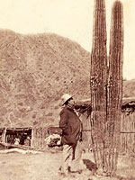
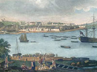
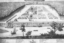
Web de Anza presents material relating to Juan Bautista de Anza's two expeditions into Alta California that resulted in the settlement of San Francisco in 1776. The site is under development, but it is easy to navigate. Visitors will find a 700-word background essay on the historical context of the expeditions and links to seven other sites about de Anza and California history. Primary source material currently includes eight diaries and two letters, available in English and Spanish and indexed by date. This material is supplemented by a gallery of 11 portraits, 14 images of scenery relevant to De Anza's expeditions, and drawings and photographs of nine objects such as a musket of the kind that De Anza probably used.

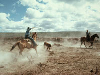
The site also includes six photographs of re-enactments of events in de Anza's expedition. An Atlas section provides 10 trail route maps, and 20 maps of the area of de Anza's expedition. The site provides useful material for students of California history, religion, and Native Americans at every level, from elementary to graduate school.

Drawing the Western Frontier: The James E. Taylor Album

Image
Annotation

This site explores James E. Taylor's legacy as a recorder of western culture. A professional artist, Taylor's newspaper illustrations served to popularize stereotypes of the Western frontier during the post-Civil War years. Like other illustrators and writers of the period, he depicted Indian-White relations in terms of savagery versus civilization and encouraged Americans to visualize the nation's Westward expansion in heroic terms. Taylor made his own illustrations, collected photographs taken by others, and constructed scrapbooks. Following Taylor's lead, the producers of this site use albums to display his work. The site includes about 750 items, taken from the 1,100 items that appeared on Taylor's 118 album pages.

Visitors can search for images by keyword, or can browse by subject or album theme. Each album image is annotated with the date the image was made, the subject, and the creator of the image, and there is an 1,800-word introductory essay for those unfamiliar with Taylor and his work. Visitors should beware that these are high-quality images, and are therefore large files. High-speed connections will make downloading much more manageable. The photographs and images in this collection are a very useful resource for researching westward expansion.

Picturing Modern America Project

Image
Annotation

It is difficult at times for young people (and people in general) to understand the past, even the more recent past of the past century or so. It seems almost banal to observe that many aspects of life have changed dramatically, and perhaps not so banal to note that many things have in fact not changed as much as we think. This fine site contains a number of interactive exercises (drawing on the vast collections of the American Memory Project at the Library of Congress) that will help deepen students' understanding of common topics in the study of modern America from 1880 to 1920 and to build their skills in analyzing primary sources.

Teachers and student alike will appreciate the "Investigations" area, which contains exercises such as "Picturing Social Change", "Modern Women", and "Picturing Prairie Life". Through the exercises, visitors will be asked a variety of questions that draw on the visual materials contained within each thematic section, such as "What brought people to the prairie?" or "Why might people have left the prairie?". Visitors also have the opportunity to build their own exhibits by choosing their own theme or question about modern America, and through choosing their own images and documents for their exhibit.

Oneida Indian Nation: Culture and History

Image
Annotation

The Oneida Indian Nation, called the "first ally and steadfast friend" of the fledgling American republic, presents documents and historical studies focusing on the Revolutionary War period and on recent efforts to pursue land claims dating from the earlier period. Includes texts of six treaties or agreements involving the Oneida and the U.S. between 1777 and 1794; statements by the U.S. Congress, Presidents, and New York State regarding the Oneida; and President Bill Clinton's 1994 memo on "Government-to-Government Relations with Native American Tribal Governments." In addition, the site offers six essays by Nation historians and others, ranging from 1,300 to 7,400 words in length, on topics such as the roles the Oneida played in the birth of the U.S. and the War of 1812, and the land claim crusade.

Includes excerpts from an oral history project in which 13 tribal elders discuss food, herbal cures, crafts, annuity cloth, language, and land claims; a timeline; 35 press releases; a cookbook; and essays on lacrosse, legends, and the tribal creation story. The site promises in the future to include significant treaties from other Indian nations. Valuable for those studying American Indian history and culture, the Revolutionary War period, and recent legal efforts by Indian nations to pursue land claims.

Washington History

Image
Annotation

This website offers resources in Washington history through three main sections: historical records research, historical newspapers and classics in Washington history, and presentations. Historical records offers county census records, naturalization records, other miscellaneous records, and genealogical research resources, as well as searches of the state archive records and the state library catalog. The newspapers and classics feature allows visitors to search and view articles from four state newspapers dating back to 1852. Users can search the newspapers by keyword, topic, or personal name. This section also has 91 classic works on Washington history, searchable by keyword, grouped under topics of county and regional history, exploration and early travel, Native Americans, pioneer life, special collections, territorial government, and wagon trails and the Oregon Trail. Individual works can also be searched. (Newspaper articles and classics must be viewed using the DJVU plugin software, available for free download on the site.)

Additionally there is a Corps 33 bibliography of more than 35 works on the Lewis and Clark expedition. There are six presentations that allow visitors to explore Washington's territorial history through an interactive timeline featuring photographs and documents, view documents relating to World War I and profiles of Washington's soldiers, read the history and view historical photographs of cities, counties and corporations, browse a collection of historical maps of the state and the Pacific Northwest, view all 78 pages of the original Washington State Constitution and learn the history surrounding it, and explore the history of elections and voting in the state. The site also offers a collection of 96 images showing the construction and early history of the state's Legislative Building.

American Memory Learning Page

Image
Annotation

Designed to provide support for elementary, middle, and high school history teachers, this site makes the entire American Memory collection at the Library of Congress available for classroom learning. Using the more than 7 million digital sources available through American Memory's 100 collections, the creators have written and collected 140 lesson plans for teaching American history. Organized chronologically and thematically, the lesson plans are detailed suggestions for classroom activities. Each has a recommended age group and uses primary sources collected by students or teachers from American Memory.

Especially useful are the included guides on using primary sources, using American Memory resources, and using digital or Internet sources in the classroom. A "Professional Development" section offers online workshops and tutorials to improve teachers' digital literacy. An excellent resource for the classroom, this site would be useful to both student and teacher.

New France, New Horizons: On French Soil in America

Image
Annotation

Designed to commemorate the 400th anniversary of the French landing in North America, this site is a collection of primary sources related to the French presence in what would later become Canada, the Great Lakes region, and Louisiana. Exhibition features 350 primary sources, including engravings, portraits, other artwork, as well as documents. They are organized by theme and are easy to find and view.

Database includes a database of more than 6,500 documents, including correspondence, reports, and maps. A special viewer allows visitors to zoom in and out of documents, making close viewing possible.

The collection is searchable by date, author, subject, or keyword. Visitors should keep in mind that although the site is written in English and French, the documents are written exclusively in French. The wealth of primary sources makes this a valuable resource for researchers, but language may prove a barrier for students and teachers.

The Story of Virginia

Image
Annotation

This attractive website offers a presentation on the history of Virginia from prehistoric times to the present with essays, images, and teaching resources. There are 10 chapters: the first Virginians; the settlement of colonial Virginia; Virginia's society before 1775; Virginians in the American Revolution; Virginians as Southerners, Confederates, and New Southerners; Virginians in the 20th century; the struggles of African American and female Virginians for equality; and a final chapter on images of Virginia in popular culture. Each chapter has an essay featuring images of relevant items in the collections of the Virginia Historical Society.

The "resource bank" collects all 95 images from the chapters of people, documents, places, and objects. Additionally, the site offers a teacher's guide for each chapter listing the standards of learning, a summary of key points, classroom activities and lesson plans, links to related websites, and information on tours, outreach programs, and hands-on-history programs.

An excellent introduction to the history of Virginia and its people with useful resources for class projects and classroom instruction.

Rare Map Collection

Image
Annotation

A collection of more than 800 maps dating from 1544 to 1939 of mostly North American locations, with an emphasis on 19th-century Georgia. Organized into nine chronological and topical divisions—New World; Colonial America; Revolutionary America; Revolutionary Georgia; Union and Expansion; American Civil War; Frontier to New South; Savannah and the Coast; and Transportation.

Includes maps of battles, American Indian nations, railroads, and roads. Useful especially for those studying military history and the development of the South.

Augustana College Library, Digital Projects

Image
Annotation

This website presents thirteen "Digital Projects" curated by librarians at Augustana College in Rock Island, IL.

The projects, most with a regional focus on Western Illinois, include: the Upper Mississippi Valley Digital Image Archive, Civil War Diaries (two diaries kept by Union Army soldiers who served near Vicksburg, MS), Early Pioneer Biographies (transcripts of 15 interviews with early settlers of the region), Farm Life (roughly 75 images of farm implements, animals, personalities, and vehicles, including the John Deere homestead), Native Americans (50 images of and interviews with local Black Hawk Indians), Quad City Views (more than 100 photographs of parks, churches, and streets in Davenport and Bettendorf, IA, and Moline and Rock Island, IL from the early 20th century), Transportation (roughly 75 images of regional animals, cars, trucks, trains, busses, trolleys, and boats in the early to mid-20th century), Town and County in Miniature: Color Plate Books at Augustana, and Cardinal Pole's Mission to England.

The Digital Image Archive is the website's largest collection, containing more than 7,000 photographs, drawings, and paintings drawn from several local academic and public libraries. These images range in date from just after the Civil War through the 1950s, and include portraits of prominent local leaders and families, sports teams and social clubs, as well as images of architecture and natural landscapes.

Town and County in Miniature is an online exhibition providing an overview of the color plate book, an illustrative form especially popular in 19th-century Britain, and its dominant genres of topography and travel, caricature, and sport.

Cardinal Pole's Mission is an online exhibition centered on a manuscript containing the correspondence of Reginald Pole (1500–1558) during two diplomatic missions from the Pope, with content created by Augustana College history students.