Three Perspectives on Native American Removal and Westward Expansion

Teaser

Check out this lesson on arguments surrounding the 1830 forced removal of the Cherokee peoples from their homeland.

lesson_image
Description

In small groups students study the arguments for and against the forced removal of the Cherokee peoples from their homeland in the 1830s.

Article Body

The two features that we like best about this lesson are the interesting primary source materials and the framework that is provided for group work related to the texts. The readings are presented as a packet of letters, documents, stories, and speeches that have been edited to make them easier for students to read. The group guidelines establish clearly defined roles within the groups. These roles compel students to look at specific features of the texts like source, context, and audience. Thus the group-work guidelines make it easier for students to see what they need to pay attention to when looking at primary sources.

The focus questions for each document which are provided at the end of the document package are also helpful. These questions help to ensure that students understand the documents, but teachers will likely want to add additional questions to meet their specific learning objectives.

The two lessons in this unit use the same basic packet of 10 readings, but neither lesson provides detailed instructions about how the materials should be used. Teachers are encouraged to select readings and questions to meet the needs of their students. Finally while neither lesson requires writing, there are a variety of opportunities to insert meaningful writing tasks into the lessons, particularly in the final assessment of the second lesson.

Topic
Native American Removal; Manifest Destiny; Antebellum South
Time Estimate
1-2 class sessions
flexibility_scale
2
Rubric_Content_Accurate_Scholarship

Yes

Rubric_Content_Historical_Background

No Background information is provided for teachers but not for students.

Rubric_Content_Read_Write

No The lesson requires close reading of documents, but little to no writing. We recommend that teachers use the guiding and focus questions to create their own writing assignments.

Rubric_Analytical_Construct_Interpretations

Yes The Audience, Connector, and Time Researcher roles in the group task require students to search documents for evidence and interpret the significance of what they read.

Rubric_Analytical_Close_Reading_Sourcing

Yes Only limited information about where resources come from can be found in the edited documents. Fuller information about the sources can be found in the Resources section of the unit.

Rubric_Scaffolding_Appropriate

Yes The lesson is flexible to meet the needs of a wide range of students.

Rubric_Scaffolding_Supports_Historical_Thinking

Yes Tasks within the group-work structure are arranged in order of difficulty—teachers can select the appropriate level of challenge for their students. No support is provided to structure student note-taking on group presentations, however.

Rubric_Structure_Assessment

Yes We recommend the suggested assessment activity where students respond in writing to one or both of the initial guiding questions. No explicit assessment criteria are provided.

Rubric_Structure_Realistic

No Very few directions are provided. Teachers need to select among the materials to meet the needs of their own students and classrooms.

Rubric_Structure_Learning_Goals

Yes The learning objectives are clearly stated, but teachers will likely want to focus on just one or two of the four objectives.

Lewis and Clark: Same Place, Different Perspectives

Teaser

How geography influenced interactions among Lewis, Clark, & Native Americans.

lesson_image
Description

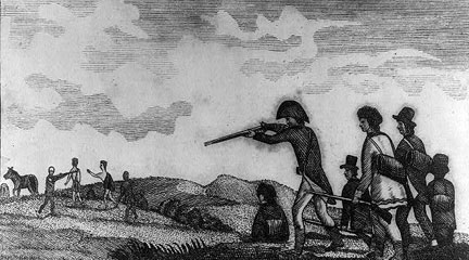
In small groups, students analyze short excerpts from primary sources and secondary information that describe an encounter between the Lewis and Clark expedition and a Native American tribe. They share their analysis with the class and consider how varied locations influenced the ways in which the explorers and the various Native tribes interacted.

Article Body

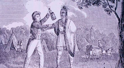
Encouraging students to work collaboratively in groups, this lesson asks students to think and write about history from multiple viewpoints. The primary source excerpts, primarily from the expedition members’ journals, are a bit challenging, but they are brief and informative. Short expository passages describe different Native American groups and their encounter with the expedition. The absence of primary documents from the Native American perspective provides an opportunity to discuss what sources of information make up the historical record.

Additionally, and maybe more importantly, the lesson engages students in geographic analysis. Using geographic indicators, students must locate each encounter at a specific site on expedition maps. Students consider the varied physical environments that Lewis and Clark encountered and how these connect to cultural variations between the Native American tribes whom they met. This lesson pays special attention to the differences between Native American cultures, countering a common student belief that all Indians lived alike.

We like the closing activity where each group reports back to the whole class before a large group discussion on the similarities and differences between the encounters. The suggested assessment asks students to write about one of the encounters from the perspective of Sacagawea, Lewis and Clark’s Native American guide, or York, a slave on the expedition. Unless this lesson is taught in conjunction with the film or other rich resources providing additional background information, this assessment seems ill-suited as students likely need more background to complete these essays successfully.

Topic
Lewis and Clark Expedition
Time Estimate
1 class period
flexibility_scale
4
Rubric_Content_Accurate_Scholarship

Yes Uses primary sources from the Lewis and Clark expedition.

Rubric_Content_Historical_Background
No We recommend that teachers include additional background information.
Rubric_Content_Read_Write

Yes Students read about environments, resources, and daily life in different places and write about how and why people from different groups perceived events differently.

Rubric_Analytical_Construct_Interpretations

Yes Students' historical and geographic analysis skills are fostered through interpretation of primary and informational texts and maps.

Rubric_Analytical_Close_Reading_Sourcing

Yes Students must read documents and maps closely in order to compare different perspectives.

Rubric_Scaffolding_Appropriate

Yes Some of the document prose is challenging, but grouping students by mixed ability can help address comprehension issues.

Rubric_Scaffolding_Supports_Historical_Thinking

No Teachers may need to create scaffolding questions to guide their students during group work.

Rubric_Structure_Assessment

No Assessment is vague. Teachers may wish to design their own assessments that involve students in viewing the expedition from multiple viewpoints or considering how location influences cultural variation.

Rubric_Structure_Realistic

Yes The directions are clear and all of the materials available on the web are easily reproducible for classroom use

Rubric_Structure_Learning_Goals

Yes Activities require students to examine an event from multiple viewpoints. Students also have the opportunity to see how geography influenced both Native American groups and the expedition members .

National Register of Historic Places Travel Itineraries

Image
Annotation

San Francisco during World War II, Mississippi's Indian Mounds, and Cumberland, Maryland, are just three of the more than 50 cities, towns, and rivers across the U.S. to which this website provides virtual access. In Baltimore, Maryland, a clickable map allows users to wander from the USCGC Taney (the last surviving warship present at Pearl Harbor on December 7, 1941) docked at Baltimore's Inner Harbor, to the house where Edgar Allen Poe lived in the mid-1830s, to the Union Square-Hollins Market Historic District to learn about Baltimore's oldest public market still in operation, and on to 40 more sites around the city. Each landmark is introduced with photographs, brief essays providing historical context, and tourist information.

Some travel itineraries are grouped by theme. For example, Historic Places of the Civil Rights Movement presents information on Arkansas's Little Rock Central High School, Virginia's Robert Moton High School, and the Lorraine Hotel in Memphis where Dr. Martin Luther King, Jr. was assassinated on April 4, 1968. Many of these sites includes links to lesson plans in NPS's Teaching With Historic Places. Updated regularly, this website is useful for teachers, students, and tourists alike.

Native American Documents Project

Image
Annotation

These four collections of data and documents address Federal Indian policy in the late 19th century. The first set includes eight annual reports of the Commissioner of Indian Affairs from the 1870s, along with appendices and a map. The second set, Allotment Data, traces the Federal "reform" policy of dividing Indian lands into small tracts for individuals—a significant amount of which went to whites—from the 1870s to the 1910s. This set includes transcriptions of five acts of Congress, tables, and an essay analyzing the data.

The third set includes 111 documents on the little-known Rogue River War of 1855 in Oregon, the reservations set up for Indian survivors, and the allotment of one of these reservations, the Siletz, in 1894. The fourth set provides the California section of an ethnographic compilation from 1952.

American Radicalism Collection

Image
Annotation

This website contains 129 pamphlets, documents, and newsletters produced by or relevant to radical movements. Groups represented by one to 30 documents include the American Indian Movement; Asian Americans; the Black Panthers; the Hollywood Ten; the Ku Klux Klan, the IWW, and the Students for a Democratic Society. Additional situations covered include the Rosenberg case, Sacco and Vanzetti, and the Scottsboro Boys. Additional topics include birth control and the events at Wounded Knee. This is a small but useful resource on radicalism, political movements, and rhetoric.

Seattle Civil Rights and Labor History Project

Image
Annotation

The long history of struggle for equal rights by various ethnic groups in Seattle, including Filipino, Chinese, Japanese, African, and Native Americans; Jews; and Latinos is documented on this website. Primary and secondary sources integrate labor rights movements with struggles for political rights, as is evident in the "special sections," that highlight the Chicano/a movement, the Black Panther Party, Filipino Cannery Unionism, the United Construction Workers Association, Communism, and the United Farm Workers. Each section brings together oral histories, documents, newspapers, and photographs that are accompanied by written and video commentary to provide historical context. The collection of more than 70 oral histories of activists is especially useful for understanding the lived experience of racism and its especially subtle workings in the Pacific Northwest. Together, these resources provide important national context for the civil rights struggle, too often understood as a solely southern phenomenon.

Touring Turn-of-the-Century America

Image
Annotation

The Detroit Publishing Company mass produced photographic images—especially color postcards, prints, and albums—for the American market from the late 1890s to 1924. This collection offers more than 25,000 glass negatives and transparencies and about 300 color photolithographs from this company. It also includes images taken prior to the company's formation by landscape photographer William Henry Jackson, who became the company's president in 1898. Jackson's work documenting western sites influenced the conservation movement. Although many images were taken in eastern locations, other areas of the U.S., the Americas, and Europe are represented. The collection specializes in views of buildings, streets, colleges, universities, natural landmarks, and resorts, as well as copies of paintings. Nearly 300 photographs were taken in Cuba during the Spanish-American War. About 900 Mammoth Plate Photographs include views of Hopi peoples and their crafts and landscapes along several railroad lines in the 1880s and 1890s.

Lakota Winter Counts

Image
Annotation

This anthropological exhibit displays, explains, and interprets the Lakota pictorial histories known as winter counts. Featuring a searchable database of winter count images, a documentary about Lakota history and culture, and video interviews with Lakota people, website visitors can view images from 10 winter counts and examine their symbols in detail by year with curator comments. Visitors are also able to examine the various symbols used by the winter count keepers to represent plants and animals, ceremonies, health, trade goods, places, people, the U.S. government, and the sky. "Who Are the Lakota" offers a historical overview of Lakota history in 10 segments that include the Lakota and the Sioux people, Lakota origins, westward migration, horse-centered culture on the northern Great Plains, important conflicts and treaties, confinement to the Great Sioux Reservation, and subsequent land cessions.

Colonial Connecticut Records, 1636-1776

Image
Annotation

This scanned and partially searchable version of the 15-volume Public Records of the Colony of Connecticut, from April 1636 to October 1776, was originally published between 1850 and 1890. Users can search documents by date, volume, and page number. Each of the 15 volumes, covering consecutive time periods, includes alphabetical, hyperlinked subject terms for browsing. The site also provides access by type of material: charters, documents, inventories, laws, letters, and court proceedings. Keyword searching may be available in the future, but even without this option, the site offers a wealth of accessible material on politics, legal matters, Indian affairs, military actions, social concerns, agriculture, religion, and other aspects of early Connecticut history.

Using Maps as Primary Sources

Image
Article Body

This website shows a 4th-grade teacher in northern Virginia teaching a lesson focused on a map drawn by John Smith that was published in 1612. Source Analysis, a feature created for the Loudoun County (Virginia) (TAH) website, has three sections focused on this primary source: scholar analysis, teacher analysis, and classroom practice. The latter two sections show a standards-based lesson that asks students to answer the question: What is important to John Smith? The teacher carefully plans activities so students look closely at the map and consider how this primary source helps them answer the central question. The site provides examples of two promising practices:

  • Engaging young students in close, careful observation and reading of a primary source document (using student pairs and a comparative document); and
  • Using students' observations to inform and guide analysis and connect the source to larger questions and topics in the curriculum.
The Lesson in Action

In the Classroom Practice section, we see the lesson in action. The teacher introduces the lesson question and then takes time to ensure that students understand the question by introducing synonyms for "important" and reviewing word meanings. She passes out the maps to assigned student pairs and asks them, "What do you see?" Students have time to look carefully at the map and notice words (e.g., "Jamestown" and "Powhatan"), the Chesapeake Bay and its tributaries, living structures, trees, how particular words vary in size and spacing, and so on. The teacher further facilitates the students' observation by juxtaposing the 1612 map with a contemporary textbook map of the same region. This juxtaposition helps students see the choices John Smith made in drawing this map that they might have missed without the comparative source. The teacher then uses what students notice about these maps to help them think about what the details and differences mean. Students start to identify what was important to John Smith and subsequently to the Virginia Company, given the evidence in front of them. Throughout this instruction, the teacher uses feedback, a logical sequencing of activities, and clear and accessible questions to ensure access to the learning activities for all of her students.

Thinking Like Historians

This teacher shows how carefully structured lessons that use primary sources can engage students in the process of thinking like historians. Students slow down and carefully read and look at the map, noticing things that they might otherwise have missed. They then consider what the contents of the map mean and what the map tells us about John Smith and the Virginia Company's worldview. The 1612 map becomes a window into the past that only reveals its slice of the landscape with close reading. Also on this site is a Teacher Analysis section in which the teacher explains some of what preceded this lesson and her instructional choices—a useful complement to the classroom videos. Each of these sections presents information in a set of videos that are clearly titled and visually interesting.