Web de Anza

Image
Annotation

Web de Anza presents material relating to Juan Bautista de Anza's two expeditions into Alta California that resulted in the settlement of San Francisco in 1776. The site is under development, but it is easy to navigate. Visitors will find a 700-word background essay on the historical context of the expeditions and links to seven other sites about de Anza and California history. Primary source material currently includes eight diaries and two letters, available in English and Spanish and indexed by date. This material is supplemented by a gallery of 11 portraits, 14 images of scenery relevant to De Anza's expeditions, and drawings and photographs of nine objects such as a musket of the kind that De Anza probably used.

The site also includes six photographs of re-enactments of events in de Anza's expedition. An Atlas section provides 10 trail route maps, and 20 maps of the area of de Anza's expedition. The site provides useful material for students of California history, religion, and Native Americans at every level, from elementary to graduate school.

San Francisco Historical Photograph Collection

Image
Annotation

This collection of 30,000 historical photographs contains scenes of San Francisco from 1850 to the present and includes views of streets, buildings, and neighborhoods, as well as photographs of famous San Francisco personalities. Visitors can search for photographs by neighborhoods using the interactive map, one of the site's most engaging options. There are also miniature tours of such locales as the Barbary Coast, Nob Hill, and Telegraph Hill.

The San Francisco neighborhoods are searchable through a list of subjects, which includes monuments, nightclubs, orphanages, parks, and stadiums.

There are several specialized collections, such as the James A. Scott Collection featuring 27 pairs of "before-and-after" images of the city with the photographer's notes and comments.

A photo morgue of the daily newspaper, San Francisco News-Call Bulletin, dating from the 1920s to 1965, completes the site.

Discovering Angel Island: The Story Behind the Poems

Teaser

Learn about the experiences of immigrants detained at Angel Island and how this impacted their opinion of the US.

lesson_image
Description

Students explore the immigrant experience at Angel Island through the analysis of poetry written by immigrants during detention at the San Francisco Bay island.

Article Body

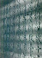
Many U.S. history classrooms devote significant time to understanding the immigrant experience. In teaching the immigrant experience, however, many classrooms focus exclusively on European immigration through Ellis Island. This lesson, The Story Behind the Poems, provides students with an excellent opportunity to learn about Asian immigration through Angel Island, and the ways in which the Asian immigrant experience differed from the European immigrant experience. The topics covered in this lesson would be an excellent addition to a unit on immigration, and would couple nicely with lessons on Chinese Exclusion and nativism in the West. The lesson first provides students with excellent historical background through an on-line video about Angel Island. The lesson then positions students to better understand the Asian immigrant experience through an analysis of poetry left by Asian immigrants on the cell walls of Angel Island. The poetry analysis allows students to connect with the words of the immigrants and hone the skill of analyzing the perspective of an author in a literary piece from the past. The lesson is highly structured and provides plenty of guidance for teachers who are not experienced in using poems as primary historical documents. The lesson includes sample questions to pose with students while analyzing the poems and also provides students with a graphic organizer to help them organize their thoughts as they prepare to write a reflection on a poem.

Topic
Immigration; Asian American history; western settlement
Time Estimate
1-2 50-minute periods
flexibility_scale
4
Rubric_Content_Accurate_Scholarship

Yes The background and resources are historically accurate and contain links to supplementary materials.

Rubric_Content_Historical_Background

Yes A high-quality video introduces students to the immigrant experience at Angel Island and is also a great resource for teachers who are teaching about Angel Island for the first time. Comparative immigration timelines are also excellent resources.

Rubric_Content_Read_Write

Yes Students interpret poems and write a reflection on the meaning of the poem and the perspective of the author.

Rubric_Analytical_Construct_Interpretations

Yes

Rubric_Analytical_Close_Reading_Sourcing

Yes The poetry analysis requires close attention to meaning and intent.

Rubric_Scaffolding_Appropriate

Yes This lesson is appropriate for the students in late elementary to early middle school.

Rubric_Scaffolding_Supports_Historical_Thinking

Yes Materials include teacher guidelines for helping students analyze the poems and a graphic organizer to help students organize and focus their thoughts about the poems.

Rubric_Structure_Assessment

No Students are assessed based on in-class discussion and a written reflection about the poems. However, the lesson does not provide specific criteria for assessing performance on the reflection.

Rubric_Structure_Realistic

Yes The lesson-plan is clear and can be easily adapted to a wide variety of classroom settings.

Rubric_Structure_Learning_Goals

Yes The lesson aims to 1) teach about the Angel Island experience, and 2) provide opportunities to analyze and interpret poetry. The lesson progresses logically to these goals.

Native American Documents Project

Image
Annotation

These four collections of data and documents address Federal Indian policy in the late 19th century. The first set includes eight annual reports of the Commissioner of Indian Affairs from the 1870s, along with appendices and a map. The second set, Allotment Data, traces the Federal "reform" policy of dividing Indian lands into small tracts for individuals—a significant amount of which went to whites—from the 1870s to the 1910s. This set includes transcriptions of five acts of Congress, tables, and an essay analyzing the data.

The third set includes 111 documents on the little-known Rogue River War of 1855 in Oregon, the reservations set up for Indian survivors, and the allotment of one of these reservations, the Siletz, in 1894. The fourth set provides the California section of an ethnographic compilation from 1952.

USC Archival Research Center

Image
Annotation

These varied collections document the history of Los Angeles and southern California. "Digital Archives" offer more than 126,000 photographs, maps, manuscripts, texts, and sound recordings in addition to exhibits. Nearly 1,200 images of artifacts from early Chinese American settlements in Los Angeles and Santa Barbara are available, as is the entire run of El Clamor Publico, the city's main Spanish-language newspaper from the 1850s. Photographs document Japanese American relocation during World War II and photographs, documents, and oral history audio files record Korean-American history. The archive also includes Works Projects Administration Land Use survey maps and Auto Club materials. A related exhibit, "Los Angeles: Past, Present, and Future", offers collections on additional topics, including discovery and settlement, California missions, electric power, "murders, crimes, and scandals," city neighborhoods, cemeteries, Disneyland, African American gangs, and the Red Car lines.

Chinese in California, 1850-1925

Image
Annotation

These 8,000 items document the immigrant experience of Chinese who settled in California during the 19th and early 20th centuries. Materials include photographs, letters, diaries, speeches, business records, legal documents, pamphlets, sheet music, cartoons, and artwork.

Access is provided through nine galleries, each containing an introductory essay and 70 to 575 items. Four galleries present materials on San Francisco's Chinatown, including architectural space, business and politics, community life, and appeal to outsiders. Additional galleries deal with Chinese involvement in U.S. expansion westward; communities outside San Francisco; agricultural, fishing and related industries; the anti-Chinese movement and Chinese exclusion; and sentiments concerning the Chinese. Visitors may search by keyword, name, subject, title, group, and theme. The site will be useful for studying ethnic history, labor history, and the history of the West as well as Chinese-American history.

Amateur Athletic Foundation Digital Archive

Image
Annotation

For those studying the history of the Olympics, sports history, and the history of leisure and recreation, this website provides more than 45,000 documents (in .pdf format) pertaining to official Olympics history as well as other sports. Complete or partial runs of 10 journals have been digitized, including Journal of Sports History (3,030 articles from 1974–2003), Olympic Review (1901–2003), Baseball Magazine (1909–1918), American Golfer (1908–1911), Golf Illustrated and Outdoor Man (1914–1915), and Outing (1883–1899).

The site also furnishes 58 oral histories of Southern California Olympic athletes and 83 official Olympic Reports from 1896 to 2004. The full text of This Great Symbol: Pierre de Coubertin and the Origins of the Modern Olympic Games by John MacAloon and some recent studies of aspects of sports history are also available. Additions to the site are made regularly.

Trails to Utah and the Pacific: Diaries and Letters, 1846-1869

Image
Annotation

Diaries documenting the westward treks of 45 men and four women during the period of the California Gold Rush and the westward migration of Mormonism are presented in this site. Although most of these travelers took either the California or Mormon trails, a few diaries provide accounts describing life on trails to Oregon and Montana.

The diaries are complemented by 82 photographs and illustrations in addition to 43 maps, including an interactive map displaying trails, cities, rivers, and landmarks. There are seven published guides, two essays on the Mormon and California trails, brief biographies of most of the diarists, and a list of suggested readings. This is an excellent collection of materials that documents 49 individual perspectives on a movement that encompassed an estimated 500,000 people.

Museum of the City of San Francisco

Image
Annotation

These 11 exhibits address the history of California and San Francisco. Topics include the Gold Rush of 1849; earthquakes of 1906 and 1989; the history of the city's fire department; construction of the Golden Gate and Bay Bridges; and the internment of Japanese Americans during World War II. These exhibits provide timelines and links to more than 200 primary documents and images, including newspaper articles, diary entries, oral histories, photographs, political cartoons, and engravings. Two exhibits are hyperlinked chronologies pertaining to San Francisco during World War II and the rock music scene in the city from 1965 to 1969.

Documents can be accessed according to subject, with more than 25 documents listed on the Chinese-American community, fairs and expositions, and labor issues. The site also contains more than 150 biographies of prominent San Franciscans.

The 1906 San Francisco Earthquake and Fire

Image
Annotation

Created to commemorate the 100-year anniversary of the San Francisco earthquake, this exhibit and archive features an extensive collection of primary source material, an interactive map, and a 360-degree view of the damage to the city. The primary sources include thousands of images and text files available, offering more than 8,000 photographs, 500 cityscapes, and 500 letters, as well as a host of additional resources, such as broadsides, oral history texts, periodical articles, photomechanical prints, reports, and stereographs. Visitors can browse the archive by genre or subject or search by keyword, subject, genre, or geographic location.

The exhibit has five galleries, each with several text/photograph displays: San Francisco before the fire; the earthquake; the fire, including a map showing burned districts; the story of refugees and survivors; and reconstruction. The interactive map divides San Francisco into 10 regions, each of which can be browsed or searched for images taken in that region. It also includes 11 aerial cityscape views. The 360-degree panoramic view of San Francisco shortly after the disaster is composed of 11 separate photographs taken from the roof of the Fairmont Hotel.