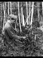
Roosevelt's Tree Army

field_image
Question

I'm looking for projects in Onondaga and surrounding counties in New York done by the Civilian Conservation Corps or the Works Progress Administration, especially monuments, parks or buildings still in existence.

Answer

The Civilian Conservation Corps (CCC) began in early 1933, under its FDR-appointed director, Robert Fechner, a union leader who had previously been the vice president of the International Association of Machinists. The CCC was a public work relief program for unemployed young men, aged 18-25, who worked on government-owned lands, mostly on natural resource conservation projects. The U.S. Army ran the program, which was therefore sometimes jocularly referred to as “Roosevelt’s Tree Army.” It ended in 1942. The CCC’s Second Corps Area included New York and New Jersey, and in these two states there were 75 camps, most of which resembled rustic World War I Army camps. Some of them were essentially tent towns and were occupied only during the warmer seasons, but others served as winter quarters as well and were constructed of timber buildings and masonry. The enlistees who served in each camp generally came from all over the country. The young men who enlisted from Onondaga County, for example, were transported by train to Fort Dix, New Jersey, where they were given some very basic training before being assigned to CCC camps around the country.

Corps Work in Onondaga County

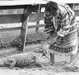
The CCC, from its winter quarters at Camp 55 on the south side of Upper Green Lake State Park near Fayetteville, worked on the construction of the Green Lakes golf course a half-mile away. The course is still open. The Fayetteville Free Library has an online exhibit about the work of the CCC at Green Lakes State Park, which includes interesting photos of the CCC at work on the park. In Pratt’s Falls County Park, in Manlius, 6 miles southeast of Syracuse, the CCC worked throughout the park on stone retaining walls, roads, trails, buildings, and bridges. In Morgan Hill State Forest the CCC planted millions of conifer trees from seedlings trucked in from the Corps’ tree nursery near Albany. On the Onondaga Reservation, the National Youth Administration and the WPA funded a community center built in 1940 by Indian youth, as well as a model program for training Indians who were then employed as youth camp counselors in the region. Except for the emergency occasioned by a forest fire in October 1935, when 150 CCC men from nearby camps were brought in to help fight the fire, the main CCC did not extend its work into the reservation. Instead, a separate organization—in keeping with the tribe’s sovereignty—called the Indian Emergency Conservation Work Program (IECW), which was renamed the Civilian Conservation Corps-Indian Division (CCC-ID) in 1937—was run by the Bureau of Indian Affairs, but with all projects cleared by the tribal council and employing Indian workers. These projects included the development of forest land, clearing brush, the straightening of roads, watershed protection, boundary demarcation, flood control and soil erosion measures, and the construction of drainage ditches between 1935 and 1937.

Corps Work in Other Counties Nearby

Near CCC Camp 15, known as “Cross Clearing Camp,” at Tupper Lake, in Franklin County, the WPA had undertaken a project in 1933-34 to reconstruct the dam on the Lower Racquette River to control the water level. Soon afterward, the CCC had their enlistees clearing rocks, stumps and debris out of the river course to allow navigation on the river and to make it possible to float logs downstream. The site of the Tupper Lake CCC camp is apparently still discernible and directions for finding it are in a 2006 article by Tupper Lake town historian Bill Frenette. A list of other CCC camps in the Adirondacks (and so generally northeast of Onondaga County), is on history researcher Marty Podskoch’s Civilian Conservation Corps Stories website. A CCC camp was established at Gilbert Lake State Park, in the town of New Lisbon, north of Oneonta in Otsego County. Nowadays the park features the New York State Civilian Conservation Corps Museum, one of 12 CCC museums around the country. It displays photos and memorabilia from CCC work at the park and elsewhere. The Corps built many of the park’s 221 campsites and 33 cabins that are still in use today. At Camp 31 at Chittenango Falls State Park, in Madison County, near Cazenovia, the CCC worked on the park’s trails and roads and built the stone facilities and shelters that are still there. At Camp 20 at Selkirk Shores State Park, near Pulaski in Oswego County on Lake Ontario, the CCC cleared trees and brush for public campsites (still open) and created a swimming beach (now closed), reforested conifers, straightened small streams, and cleared the bank of the Salmon River for public access. Also in Oswego County, the WPA and CCC planted conifers in land around Kasoag and built Mosher, Whitney and Long Ponds by constructing small dams. One of the lasting effects of the CCC, which is certainly still "visible" in a sense, not only in rural New York but also throughout the country, was its fostering of a basic kind of conservationist view of America's wilderness areas among its enlistees and their families. As a consequence, it played a strong part in the birth of what we know regard as the environmental movement.

For more information
Bibliography

“CCC Job Army Braves Bitter Winds in Nearby Camps Before Being Ordered Into Warmer Winter Quarters,” Syracuse Herald, November 19, 1933. [On the Chittenango Falls Camp] “Camp 55 CCC Settles Comfortably Into New Quarters, 14 Buildings at Green Lake State Park,” Syracuse Herald, December 20, 1933. “Syracuse and County Youths Enlist for Winter Service at CCC Camps,” Syracuse Herald, November 3, 1933. Laurence Hauptman and Laurence M. Hauptman, The Iroquois and the New Deal. Syracuse: Syracuse University Press, 1988.[book preview]

National Agricultural Statistics Service

Article Body

According to the service website, "The USDA's National Agricultural Statistics Service (NASS) conducts hundreds of surveys every year and prepares reports covering virtually every aspect of U.S. agriculture. Production and supplies of food and fiber, prices paid and received by farmers, farm labor and wages, farm finances, chemical use, and changes in the demographics of U.S. producers are only a few examples."

Helping students to conceptualize history is a goal (and a difficulty) for many teachers. How can what's past be presented in a manner that feels relevant to students? If you live in a somewhat rural area, NASS's charts and maps may provide a great point of comparison between the local past and the present. Say you are studying cotton production in the south. Why not find information on how much cotton we still produce? If you're from another part of the country, consider seeing how much corn your vicinity harvests today. You can select topics such as specific livestock or crops.

Also, be sure to check out the available multidisciplinary lesson plans. The K-3 option includes a reading on Washington and the first agricultural survey, as well as an activity involving counting, while the 9-12 activities include short excerpts of Washington's words. Subject emphases vary. Don't miss the glossary of terms.

Tennessee Valley Authority

Article Body

In 1933, President Franklin Roosevelt initiated a new agency which combined aspects of governmental and private organizations. Over time, the resulting agency, the Tennessee Valley Authority or TVA, has researched issues as far-ranging as malaria, reforestation, power, flooding, navigation, and erosion. In their own words, the TVA serves the "valley through energy, environment, and economic development."

Admittedly, the TVA website was not designed for K-12 education. However, as a major initiative of the New Deal, it is an important milestone in U.S. history. For that reason, if you need to teach the New Deal, you may want to read From the New Deal to the a New Century: A Short History of TVA, which includes a link to the original TVA Act. The TVA Heritage archive focuses on more specific snippets of TVA history.

Also worth a look is the TVA kids' site, which includes answers to questions like "Who developed the Cherokee alphabet?" and "In 1930, how many Americans living on farms had electricity?" Resources specifically developed for teachers lean toward the sciences.

Voices of the Colorado Plateau

Image
Annotation

Offers more than 40 multimedia presentations featuring oral history excerpts and photographs that document aspects of life in the Colorado Plateau--encompassing parts of Utah, Arizona, New Mexico, and Colorado--during the past half century. Also presents audio files of 10 complete oral histories and transcripts of the interviews ranging from 2,200 to 19,000 words in length. A joint project of eight libraries and museums in the four Colorado Plateau states and Nevada, the site is organized into three sections--People, Places, and Topics--with subheadings that allow visitors to access the audio excerpts, many of which are accompanied by slide shows of photographs. The people interviewed include a Navajo language interpreter, the son of homesteaders, a schoolteacher, a pioneer in commercial river running, and an administrative officer for a town built for dam workers. Topics range from sociocultural concerns, such as growing up, education, families, food, and leisure, to work- and environment-related subjects, including ranching, timber, and tourism. Valuable for those studying the American West and the use of oral history for exhibit presentations.

Surveyors of the West: William Henry Jackson and Robert Brewster Stanton

Image
Annotation

This site presents the journals and photographs of two men who surveyed the western states in the second half of the 19th century. William Henry Jackson was a photographer, artist, and writer who traveled along the route of the Union Pacific Railway in 1869. The site provides access to his journal of the expedition, 36 stereoscopic photographs he took along the way, and 13 mammoth prints Jackson made of sites in Colorado and Wyoming. Jackson's diary describes how he took and developed photographs during the expedition. Robert Brewster Stanton was a civil engineer who surveyed canyons in Colorado for the Colorado Canyon and Pacific Railroad Company between 1889 and 1890. Visitors to the site can read a facsimile of his typed field notes in four volumes. The notes and 36 photographs provide geologic information, but also give a sense of the everyday life of the expedition. The site includes a 500-word biographical essay for each man and finding aids for the larger collections of their papers housed at the New York Public Library. This site is easy to navigate and is useful for studying western states, the environment, and photography in the 19th century.

Pioneering the Upper Midwest: Rare Books c. 1820-1910

Image
Annotation

This American Memory website traces the history of the Upper Midwest (Michigan, Minnesota, and Wisconsin) from the 17th century to the early 20th century, through 138 volumes drawn from the Library of Congress General Collection and the Rare Books and Special Collection Division. Selected works include first-person accounts, biographies, promotional literature, local histories, ethnographic and antiquarian texts, and colonial archival documents that depict the region's land and resources, cross-cultural encounters, experiences of pioneers and missionaries, soldiers, immigrants, reformers, growth of communities, and development of local culture and society. Each work is available in full-text transcription or page image, and is accompanied by notes giving the title, author, publication information, and a 300–350 word summary of the contents.

The site also offers a 2,000-word essay on the history of the Upper Midwest that covers the discovery, exploration, settlement, and development of the region from pre-contact to the early 20th century; a regional map dated 1873; links to more than 40 related websites; and a bibliography of nine related works, three of which are ideal for younger readers. The site can be searched by keyword and browsed by author, subject, and title. For those interested in the history of the Upper Midwest and Great Lakes region, this site offers some informative resources.

American Environmental Photographs, 1891-1936

Image
Annotation

These approximately 4,500 photographs document natural environments, ecologies, and plant communities in the United States at the end of the 19th and the beginning of the 20th century. Produced by American botanists between 1891 and 1936, the photos describe various ecosystems and landforms across the United States. Users can search for specific plants and some animals as well as for landforms, natural events, and weather patterns.

The collection is a bit odd in that it mixes genres and types. Clicking on the region "Pennsylvania" produces eight images, ranging from pictures of dogwoods to a photo of tree rings to three pictures of the Pittsburgh flood. A timeline and an essay on "Ecology and the American Environment" provide valuable background information as well as a bibliography. These materials are useful as record of early environmental thinking as well as a document of vanished landscapes.

Rivers, Edens, Empires: Lewis and Clark and the Revealing of America

Image
Annotation

Thomas Jefferson outlined three motivating factors in his instructions to Lewis and Clark: a search for navigable rivers to span the continent; a quest for Edenic beauty and riches; and the competitive desire to acquire a continental empire. These 180 documents and artifacts interpret 19th-century westward exploration from this perspective. The range of materials is striking. In addition to maps, plans, and charts, the site offers images (sketches, watercolors, etchings, and engravings), texts (letters, diaries, speeches, newspapers, and books), and tools (surveying and medical instruments, cooking utensils, armaments). The exhibit opens with an examination of the "imperial mentality" common to Virginia's aristocratic class in the late 18th century and then focuses on the Lewis and Clark journey. It ends with the subsequent expeditions of Zebulon Pike, Stephen H. Long, Charles Wilkes, John Charles Fremont, and the mid-19th century transcontinental railroad plan that supplanted the search for a water route.

Reclaiming the Everglades: South Florida's Natural History, 1884-1934

Image
Annotation

This archive contains primary and secondary sources relating to reclamation efforts of the Everglades and the history of south Florida from 1884 to 1934. Comprising nearly 10,000 pages and images, the compilation includes personal correspondence; government publications, reports, and memos; and images, such as photographs, maps, and postcards. Materials document issues relating to the creation of national parks, including conflicting interests—public, private individual, and corporate—and government accountability.

The website also presents a photo exhibit, "The Everglades: Exploitation and Conservation," accompanied by a 1,000-word essay. Two additional features, an interactive timeline and 31 biographies of South Florida's most notable personalities, complete this project. This site will be of interest for those exploring the establishment of the Everglades National Park, the conservation movement, and the treatment of Native Americans, particularly the Seminoles.