Federal Township Plats of Illinois, 1804-1891

Image
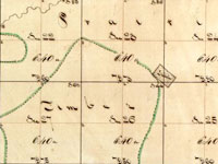
Plat, Virgil, 27-59
Annotation

Designed as both an archive and an online exhibit, this site features 3,457 hand-drawn township maps of Illinois. When the government began surveying in 1803 what would later become Illinois, they divided the land into squares six by six miles (36 square miles) called townships. This site includes a 1,000-word introductory history describing the surveying process and introducing the methods and tools of surveyors. Also included here are the maps, available to researchers and the public. A 1,000-word narrative outlines the role of the United States Surveyor General, and traces the custody of these records through the years.

Visitors use a map of Illinois to locate the region and county of the plat they wish to view, and can pan left and right or zoom in and out. A legend helps users decipher early 19th-century symbols. In addition, the site links to an Illinois state website (Illinois Public Domain Land Tract Sales), where researchers can search for the first owners of plats. This site is a great place to view original, early-19th-century maps of Illinois.

Meeting of Frontiers

Image
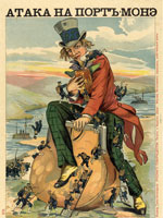
Chromolithograph, "Attack on Port Money," 1904
Annotation

In conjunction with the Russian State Library in Moscow, the National Library of Russia in St. Petersburg, and the Rasmuson Library of the University of Alaska in Fairbanks, the Library of Congress has digitized more than 2,500 items, comprising approximately 70,000 images, and provided transcriptions and commentaries in English and Russian to offer a comparative history of American and Russian expansion through frontier territories in each nation's continent. The site presents an overview of expansion into Siberia and the American West in six sections: Exploration, Colonization, Development, Alaska, Frontiers and National Identity, and Mutual Perceptions. Each section contains from two to 11 modules that call attention to similarities and differences between the two histories with regard to subjects such as migration—forced and otherwise, missionaries, religious flight, mining, railroads, agriculture, cities, popular culture, and tourism, and even compares Cossacks with cowboys.

The site offers more than 40 complete books, including manuals, handbooks, fiction, and travelers accounts; 77 maps and one atlas; 438 items from the Russian-Ukrainian Pamphlet and Brochure Collection; materials from six complete manuscript collections, regarding exploration, trade, and commercial activities; four tour-of-the-century films; 125 newspaper articles; 11 dime novel covers; five photographic collections; and one sound recording of a Russian folk song. Provides a 500-title bibliography and links to 30 related sites. Valuable for those studying the American West and Russian history and investigating ways to explore frontiers of comparative histories in order to expand beyond limits of national history narratives. Listen to the audio review: .

Mapping the National Parks

Image
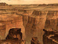
Graphic, Mapping the National Parks
Annotation

Funded by the Rockefeller Corporation and part of the Library of Congress American Memory Project, this site features approximately 200 maps that document the history, cultural aspects, and geological features of the areas that became the Acadia, Grand Canyon, Great Smoky Mountains, and Yellowstone National Parks. The maps date from the 17th century to the present and include early European, exploration, geological, environmental, United States Geological Survey, and National Park Service maps.

The site is divided into four sections, one for each of the featured national parks. Each section includes a 1200-word essay describing the history of the area and the process by which it became a national park, illustrated with five to seven maps.

The site also includes a bibliography of over 200 scholarly works on related topics. Other links include a 750-word general history of the mapping of national parks and a "Learn More About It" section that offers links to 14 Library of Congress Special Presentations and related collections and exhibits. The collection is keyword searchable and can be browsed by geographic location, subject, creator, and title. This easily navigable site is ideal for students and teachers interested in cartography, the National Parks system, and conservation in America.

Florida Heritage Collection

Image
Graphic, Florida Heritage Collection
Annotation

This project provides a collection of more than 280 digitized materials documenting the history of Florida from pre-contact to the present. It includes materials relating to Florida history, culture, arts, literature, and social sciences in a number of major thematic areas, including Native American and minority populations, exploration and development, tourism, natural environment, and regional interests. These materials are drawn from the archives, special collections, and libraries of the 10 state universities in the Florida system.

Items include family papers, local history books and booklets, diaries, advertising materials, and Civil War letters, business records, maps, and photographs. Many of the materials are regional or local in scope.

The site also includes an extensive (5000-word) Florida history narrative timeline from pre-contact (before 1492) to the present. A user guide and tutorial are provided, and the documents are searchable by county name, keyword, subject, author, or title. The search engine has an option for listing either electronic holdings only or all collection holdings under a particular subject. Entries in the electronic catalog include the archive in which the original is located as well as a 20-word description of the item and its contents.

Note that a few links are still under construction with no completion date indicated. The site is ideal for researching Florida's state and local history.

Connecticut History Online

Image
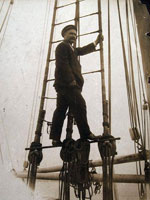
Photo, Captain George Comer of East Haddam in rigging..., 1907
Annotation

This site is a collaborative effort between the Connecticut Historical Society, the Thomas H. Dodd Research Center at the University of Connecticut, and the Mystic Seaport Museum, funded by a National Leadership Grant from the Institute of Museum and Library Services. It offers approximately 14,000 images depicting Connecticut's history from the beginning of the 19th century to the middle of the 20th century.

The images are divided into categories: "Artifacts," "Manuscripts and Documents," Maps, Charts, and Bird's-eye Views," "Newspapers and Magazines," "Photographs, Prints, and Drawings," "Posters/Broadsides," and "Sound Recordings and Transcripts." Each image includes notes on the creator, date, and place created, medium, repository information, and a brief (40-word) description of the subject. Visitors can search the site by keyword, subject, creator, title, and date.

The site also includes four sample lesson plans for middle school classes comparing and contrasting two Connecticut families and the roles of men and women through exercises interpreting the site's images, a list of ideas for future topics, and themes for secondary-level classrooms. This site is ideal for teachers and students interested in the history of Connecticut and its communities.

American Museum of Photography

Image
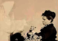
Photograph, Woman with Daisies and Spirit
Annotation

Photographs from 1839 to the late 20th century are on view in 12 exhibits that offer 100- to 600-word introductory essays and a diverse range of images.

"The Face of Slavery" presents 10 photographs of African Americans from 1855 to 1905.

The work of Southworth and Hawes, a photography team active between 1843 and 1862, is represented by eight daguerreotypes of women.

In "Do You Believe?" visitors may consider evidence of ghostly existence offered by 22 "spirit photographs" taken between 1875 and 1932.

In "Photography as a Fine Arf!," 16 photos from the 1850s to the 1950s "explore the complex relationships of people and dogs."

In "At Ease," nine photographs from around 1850 refute the popular notion that early portraiture was stiff.

An exhibit of the trick photography of William H. "Dad" Martin presents eight photos produced between 1894 and 1912 that show exaggerated ordinary objects.

In "Of Bricks and Light," the museum exhibits 33 architectural photographs.

Business executive and photographer Shotaro Shimomura took pictures of his trip around the world in 1934-35; nine of these are exhibited in "An Eye for the World."

An interactive exhibit of nine cartes de visite allows visitors to investigate details such as the hats worn by men in Abraham Lincoln's funeral procession.

"Scott Mutter: A More Perfect World" presents 11 "hyper-realistic" photomontages by the acclaimed image maker.

"Masterworks of Photography" includes 25 images produced from 1840 to 1975, including English inventor William Henry Fox Talbot's "The Footman," of 1840, considered the earliest photograph on paper of a human being.

In addition, the museum showcases 42 of its favorite pieces.

The site also provides a 1,700-word explanatory essay on photographic processes and links to 25 other resources concerning the history and art of photography. This site cannot be searched by subject, however, which limits its usefulness for research.

Alaska's Digital Archive

Image
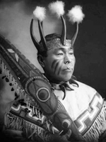
Photo, Chief Cow-Dik-Ney. . . , 1906, Case and Draper, Alaska's Digital Archive
Annotation

This website offers access to the digital collections of six Alaska universities and museums. The more than 3,700 historical images of Alaska can be browsed in their entirety or by selecting specific thematic collections organized under the two broad themes. "Alaska Native History and Cultures" has 12 collections with themes that include ceremonial life, education, native leadership and politics, making a living, and health care facilities. "Movement to Statehood" has seven collections with themes such as government, business and commerce, natural resources, transportation, and society and daily life.

Both "Alaska Native History" and "Movement to Statehood" can be browsed by region or time period. Bibliographic data accompanies each image. The user can also search the collection by phrase or keyword. Future stages of the project will add oral histories, maps, documents, and film clips in multiple formats. Alaska's Digital archive is an outstanding resource for those seeking images of Alaska's history.

Vietnam War Era Ephemera Collection

Image
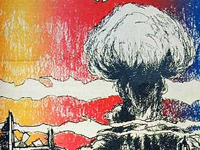
Cover, Helix, Vol. 2, no. 3 (October 20, 1967), Walt Crowley, U of WA
Annotation

This small but interesting archive of 232 items "contains leaflets and newspapers that were distributed on the University of Washington campus during the decades of the 1960s and 1970s. They reflect the social environment and political activities of the youth movement in Seattle during that period." The collection can be browsed in 24 thematic categories that include Vietnam protests, human rights, gay rights, feminism and women's issues, racism, socialism and labor, farm workers, peace candidates, environment, religion, fanaticism, "Age of Aquarius," civil liberties, freedom of speech, anarchy, communism, pro-Vietnam War, and Palestinian protests. Basic keyword and advanced searches are available. This website is a useful resource for researching the history of campus protest in the 1960s and 1970s.

Western History Photography Collection

Image
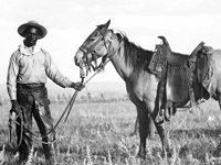
Photo, Black cowboy and horse, c. 1890-1920, Western History Collection
Annotation

This combined archive and exhibit contains more than 100,000 images, including photographs, broadsides, posters, maps, advertisements, and other documents. There is a keyword search but no feature for browsing the entire collection. Many of the images can be browsed, however, through nine "galleries," or thematic collections of selected images. "Scenic Rails of the West" is a large exhibit with seven image galleries that include towns, touring, railroads, native culture, and national parks. The "Photos West Classics" gallery is also large and includes the most frequently requested images. Topics include children, saloons, trails and covered wagons, famous Westerners, famous Native Americans, Wild West shows, and Western life. Other galleries include "Railroads," "Building Histories," and "Native American Women." All images are accompanied by a descriptive catalog record and are available for purchase. A learning page (accessed through "news") offers 18 lessons. This website is a valuable source of images on Western figures, culture, environment, politics, and economic development. Teachers of the American West will also find valuable instructional resources.

Turning Points in Wisconsin History

Image
Photo, Arthur M. Vinje, April 4, 1947
Annotation

This website allows visitors to explore the history of Wisconsin through essays, primary source documents, lesson plans, and maps. The main feature is 53 presentations grouped under 10 overall topics: early native peoples; early explorers, traders, and settlers; territory to statehood; immigration and settlement; Civil War era; mining, lumber, and agriculture; Progressive Era; 20th-century wars and conflicts; prosperity, depression, industrialization, and urbanization; and response to 20th-century change. Each topic offers four or more presentations with a short introductory essay; primary sources available on the site; primary sources available elsewhere; and related links.

Documents available on the site include more than 140 books, tracts, pamphlets, or papers; more than 100 images; more than 260 articles; and more than 35 manuscripts. The site also offers 95 reference maps. There are more than 45 elementary and 36 secondary lesson plans searchable by keyword, grade level, and/or topic. The advanced search allows visitors to search by fields such as agriculture, intellectual life, and politics; or by keyword, education level, topic, presentation, or type of document. Additionally, there is a tutorial on using primary documents. This website is a good starting point for teaching or researching Wisconsin or the mid-Western region.