Frank Lloyd Wright: Designs for an American Landscape 1922-1932

Image
Annotation

This site offers five exhibits featuring designs by Frank Lloyd Wright's for projects that were never built—a prototypical suburb, two resorts, an automobile objective, and a desert retreat. "Although none was ever realized, they embody Wright's changing views of the fundamental relationship between building and land." Each exhibit is centered on an explanatory essay that ties together images of Wright's designs. The images include hypothetical study models based on Wright's designs and Wright's own preliminary sketches.

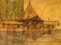
"A.M. Johnson Desert Compound" looks at a design Wright planned for the desert compound of Albert Mussey Johnson near Death Valley, CA. "Gordon Strong Automobile Objective" is focused on Wright's designs for a structure atop Sugar Loaf Mountain in Maryland to serve as a motor tourist destination and observation point. "Lake Tahoe Summer Colony" examines Wright's speculative designs for the Lake Tahoe Summer Colony at the head of Emerald Bay on Lake Tahoe, featuring floating cabins. "Doheny Ranch Development" explores Wright's designs for a residential development "of unparalleled scale" on the 411-acre ranch property of Edward Doheny outside Beverly Hills, CA. "San Marcus in the Desert" focuses on Wright's designs for a luxurious resort in the desert on 1,400 acres south of Phoenix, AZ, commissioned by a successful developer. Some of the links on the site are no longer functional and there is no search. A website of interest to those researching Frank Lloyd Wright or the history of American architecture.

The Sonic Memorial Project

Image
Annotation

This is an ambitious project that details the history of the World Trade Centers and September 11th through sound. Originally started by NPR_s Kitchen Sisters who host the radio program "Lost and Found Sound," this site harnesses the strengths of many organizations involved in image, audio, and video archiving such as Picture Projects and the September 11th Digital Archive. To date they have received more than 1,000 contributions from individuals and organizations that describe not just the thoughts or memories of September 11th survivors, but also narrations of events, such as weddings, that took place in the Towers. The site also contains a section for educators with six curriculum modules of two to three lessons each. In sum, this is an multi-sensory site that engages modern history and its impact on modern America.

National Register of Historic Places Travel Itineraries

Image
Annotation

San Francisco during World War II, Mississippi's Indian Mounds, and Cumberland, Maryland, are just three of the more than 50 cities, towns, and rivers across the U.S. to which this website provides virtual access. In Baltimore, Maryland, a clickable map allows users to wander from the USCGC Taney (the last surviving warship present at Pearl Harbor on December 7, 1941) docked at Baltimore's Inner Harbor, to the house where Edgar Allen Poe lived in the mid-1830s, to the Union Square-Hollins Market Historic District to learn about Baltimore's oldest public market still in operation, and on to 40 more sites around the city. Each landmark is introduced with photographs, brief essays providing historical context, and tourist information.

Some travel itineraries are grouped by theme. For example, Historic Places of the Civil Rights Movement presents information on Arkansas's Little Rock Central High School, Virginia's Robert Moton High School, and the Lorraine Hotel in Memphis where Dr. Martin Luther King, Jr. was assassinated on April 4, 1968. Many of these sites includes links to lesson plans in NPS's Teaching With Historic Places. Updated regularly, this website is useful for teachers, students, and tourists alike.

William P. Gottlieb: Photographs from the Golden Age of Jazz

Image
Annotation

Writer-photographer William P. Gottlieb (1917–2006) documented the New York and Washington, D.C. jazz scene from 1938 to 1948 in more than 1,600 photographs. During the course of his career, Gottlieb took portraits of prominent jazz musicians—including Louis Armstrong, Duke Ellington, Charlie Parker, Billie Holiday, Dizzy Gillespie, Earl Hines, Thelonious Monk, Ella Fitzgerald, and Benny Carter—and legendary venues, such as 52nd Street, the Apollo Theatre, Cafe Society, the Starlight Roof, and Zanzibar. The site also features approximately 170 related articles by Gottlieb from Down Beat magazine; 16 photographs accompanied by Gottlieb's audio commentary on various assignments; a 4,300-word biography based on oral histories; and a 31-title bibliography. Extremely valuable for jazz fans, music historians, musicians, and those interested in urban popular culture.

SIRIS Image Gallery

Image
Annotation

Highlights from the Smithsonian Institution are presented here, with access to a database of close to 140,000 images from Smithsonian archives and museums. The Image Gallery presents a sample of images, browsable by format, such as photographs, slides, drawings, postcards, and stereographs. Images are also organized by repository, including the Freer Gallery, the Archives Center, and the National Anthropological Archive.

"Frequently Used Images" provides a link to the most popular images, sorted by month and year. Within the Archives Center, for example, there are four collections with more than 30,000 images, including the Underwood and Underwood Glass Stereograph Collection, 1895–1921 on topics such as actors, African Americans, disasters, ethnic humor, immigration, Indians, labor, presidents, women, and World War I. The Addison N. Scurlock Collection presents more than 2,000 black-and-white images, primarily of Washington, DC, and from African American life. There are 1,500 advertisements from the Ivory Soap Advertising Collection and close to 200 postcards. All images may be searched via the "Search Images" tab.

Triangle Shirtwaist Factory Fire

Image
Annotation

On March 25, 1911, a fire broke out at the Triangle Shirtwaist Factory in New York City causing the deaths of 148 garment workers—an event that came to be known as one of the hallmark tragedies of the industrial age. This website tells the story of the fire in six chapters: Introduction; Sweatshops and Strikes; Fire; Mourning and Protest; Relief Work; and Investigation, Trial, and Reform.

The text, targeted to a middle and high school audience, is accompanied by numerous primary sources that could be of use to more advanced researchers. These include close to 70 photographs, 18 newspaper articles, 17 testimonials, three oral histories, excerpts from investigative reports written in the years following the fire, several letters from witnesses, a lecture given by Secretary of Labor Frances Perkins in 1964, and a radio drama reenacting the event. Accompanying these primary sources is a list of victims and witnesses, a selected bibliography of works surrounding the fire, and tips for writing a paper.

Slavery in New York

Image
Annotation

Focusing on the experiences of Africans and African Americans in New York City, this collection presents nine galleries that explore various themes and time periods in the history of slavery. These include the Atlantic slave trade; slavery in Dutch New York; the growth of slavery in British Colonial New York; freedom for blacks during the Revolutionary War; the Gradual Emancipation Act of 1799; free blacks in public life; Emancipation Day (July 4, 1827), and the history of scholarship on slavery in New York City. Each gallery has three panels: a gallery overview, a main thematic presentation, and one focusing on people, places, and documents. Of special interest are two interactive maps with timelines in the Dutch New York gallery and the Revolutionary War gallery; a picture gallery on the portrayal of blacks in New York City's public life; and profiles of nine African Americans who lived in New York City during the early republic.

Picturing America

Image
Annotation

Twenty-seven iconic images in American history are presented here, designed specifically to encourage educators to use images as primary source documents in the classroom. The images range in time from 17th-century depictions of the Catholic mission in San Antonio to the contemporary art of Washington, DC native Martin Puryear.

Also included are the Lansdowne portrait of George Washington, "Washington Crossing the Delaware," and Hiram Powers's statue of Benjamin Franklin, as well as works by artists such as Grant Wood, George Catlin, Winslow Homer, John Singer Sargent, Mary Cassatt, and Edward Hopper, and by photographers Walker Evans and Dorothea Lange. All images are accompanied by a brief annotation providing historical context, a biography of the artist, and a list of online resources offering further contextual information, lesson plans, and classroom activities. Images enlarge to fullscreen and are searchable by artist and by theme: Leadership, Freedom & Equality, Democracy, Courage, Landscapes, and Creativity & Ingenuity.

Using Maps as Primary Sources

Image
Article Body

This website shows a 4th-grade teacher in northern Virginia teaching a lesson focused on a map drawn by John Smith that was published in 1612. Source Analysis, a feature created for the Loudoun County (Virginia) (TAH) website, has three sections focused on this primary source: scholar analysis, teacher analysis, and classroom practice. The latter two sections show a standards-based lesson that asks students to answer the question: What is important to John Smith? The teacher carefully plans activities so students look closely at the map and consider how this primary source helps them answer the central question. The site provides examples of two promising practices:

  • Engaging young students in close, careful observation and reading of a primary source document (using student pairs and a comparative document); and
  • Using students' observations to inform and guide analysis and connect the source to larger questions and topics in the curriculum.
The Lesson in Action

In the Classroom Practice section, we see the lesson in action. The teacher introduces the lesson question and then takes time to ensure that students understand the question by introducing synonyms for "important" and reviewing word meanings. She passes out the maps to assigned student pairs and asks them, "What do you see?" Students have time to look carefully at the map and notice words (e.g., "Jamestown" and "Powhatan"), the Chesapeake Bay and its tributaries, living structures, trees, how particular words vary in size and spacing, and so on. The teacher further facilitates the students' observation by juxtaposing the 1612 map with a contemporary textbook map of the same region. This juxtaposition helps students see the choices John Smith made in drawing this map that they might have missed without the comparative source. The teacher then uses what students notice about these maps to help them think about what the details and differences mean. Students start to identify what was important to John Smith and subsequently to the Virginia Company, given the evidence in front of them. Throughout this instruction, the teacher uses feedback, a logical sequencing of activities, and clear and accessible questions to ensure access to the learning activities for all of her students.

Thinking Like Historians

This teacher shows how carefully structured lessons that use primary sources can engage students in the process of thinking like historians. Students slow down and carefully read and look at the map, noticing things that they might otherwise have missed. They then consider what the contents of the map mean and what the map tells us about John Smith and the Virginia Company's worldview. The 1612 map becomes a window into the past that only reveals its slice of the landscape with close reading. Also on this site is a Teacher Analysis section in which the teacher explains some of what preceded this lesson and her instructional choices—a useful complement to the classroom videos. Each of these sections presents information in a set of videos that are clearly titled and visually interesting.